The Aberdare National Park majestic peaks, Moorlands and falls Encircled by the wild and beautiful moorlands of the third highest mountain range in Kenya, this atmospheric Park offers a mist-wreathed realm where elephants roam through lichen-hung forests, spectacular waterfalls plunge into churning pools, and trout-filled streams cascade through mossy dells. A haven for anglers, walkers and lovers of solitude alike, it also offers matchless views of the glittering coronet of Mount Kenya and the sparkling lakes of the Great Rift Valley. What to see Enduring legacy of Kimathi ”Post Office” The park is also famous for the hideouts of freedom fighters, where Field Marshal General Dedan Kirnathi and his Mau Mau used the Mau Mau caves prior to independence. The Kimathi "post office", where agents used to drop messages for Man Mau fighters led by legendary Field Marshall General Dedan Kimathi in The Aberdare National Park and Mt Kenya forests. A window on history The Kikuyu believed it to be one of the homes of Ngai (God) and originally knew it as Nyandarua' (the drying hide) due to the distinctive folds of its silhouette. In 1884, the explorer Joseph Thompson renamed the range after Lord Aberdare, the President of the Royal Geographical Society. Dubbed the ‘White Highlands’ because of the large numbers of Europeans who settled there in the 1920's, the area also achieved notoriety due to the decadent antics of the ‘Happy Valley Set‘ of the Wanjohi Valley. Also during the l950’s, the dense forests and bamboo thickets witnessed much of the action between British forces and the ‘Man Man’ freedom fighters. The original ’"lreetops’ hotel feli under the spotiight of the world when the young Princess Eiizabeth descended its steps as Queen Elizabeth ll of England in 1952. Herds of elephant against a mountain backdrop The Pads provides
The Aberdare National Park
majestic peaks, Moorlands and falls
Encircled by the wild and beautiful moorlands of the third highest mountain range in Kenya, this atmospheric Park offers a mist-wreathed realm where elephants roam through lichen-hung forests, spectacular waterfalls plunge into churning pools, and trout-filled streams cascade through mossy dells. A haven for anglers, walkers and lovers of solitude alike, it also offers matchless views of the glittering coronet of Mount Kenya and the sparkling lakes of the Great Rift Valley.
What to see
Enduring legacy of Kimathi ”Post Office”
The park is also famous for the hideouts of freedom fighters, where Field Marshal General Dedan Kirnathi and his Mau Mau used the Mau Mau caves prior to independence. The Kimathi “post office”, where agents used to drop messages for Man Mau fighters led by legendary Field Marshall General Dedan Kimathi in The Aberdare National Park and Mt Kenya forests.
A window on history
The Kikuyu believed it to be one of the homes of Ngai (God) and originally knew it as Nyandarua’ (the drying hide) due to the distinctive folds of its silhouette. In 1884, the explorer Joseph Thompson renamed the range after Lord Aberdare, the President of the Royal Geographical Society. Dubbed the ‘White Highlands’ because of the large numbers of Europeans who settled there in the 1920’s, the area also achieved notoriety due to the decadent antics of the ‘Happy Valley Set‘ of the Wanjohi Valley.
Also during the l950’s, the dense forests and bamboo thickets witnessed much of the action between British forces and the ‘Man Man’ freedom fighters. The original ’”lreetops’ hotel feli under the spotiight of the world when the young Princess Eiizabeth descended its steps as Queen Elizabeth ll of England in 1952.
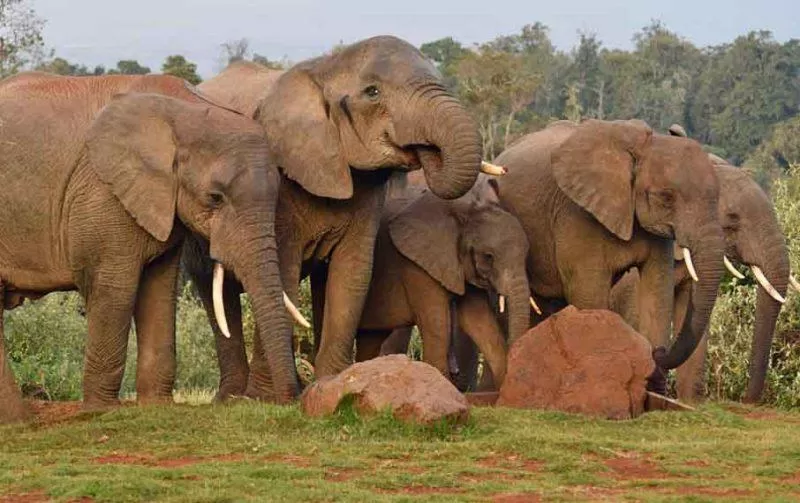
Herds of elephant against a mountain backdrop
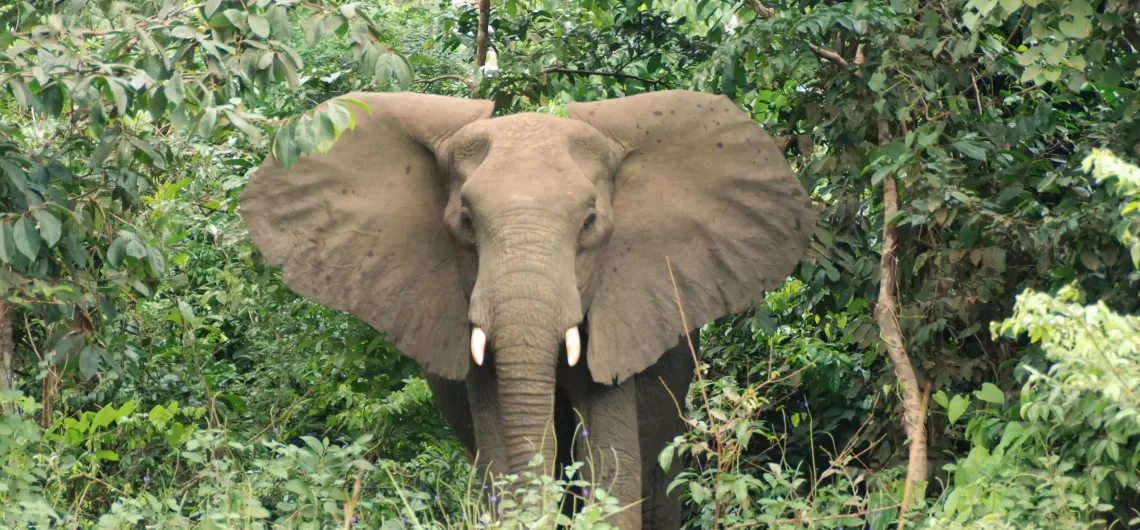
The Pads provides a unique habitat for approximately two thousand elephants, which roam the clouded hills and misty glades and provide endless atmospheric viewing opportunities.
Spectacular waterfalls
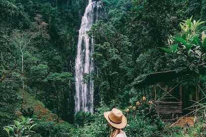
The Park is renowned for its torrential waterfalls plunging from cloud-shrouded heights to spray-filled ravines. They include the magnificent Karuru Falls, which drop 300m, the impressive Gura Falls which torrent from the opposite side of the same gorge, the sheer drop of the Chania Fails, and the enchanting Magura Falls which cascade across the yawning mouth of the Queen’s Cave.
Activity options
Mountain climbing, hiking and walking
Climbing the peaks of The Aberdare National Park doesn’t require you to be a mountaineer, as most of them can be conquered with little more than a strenuous high-altitude trek. Additionally, there are numerous panoramic moorland hikes and forest walks available. To walk, hike, or climb in the park, you need to obtain permission from the Warden and be accompanied by an armed KWS Ranger. You can book the services of the ranger by contacting the Warden, preferably in advance.
Excellent fishing in the cool mountain streams
Both brown and rainbow trout abound in the cool mountain streams and provide excellent angling. You can obtain a sports fishing license at the Park gates.
Where to stay
Lodges
The Ark, a unique day and night game-viewing lodge modelled on Noah’s Ark. Contact: Fairmont Hotels, PO Box 58581 (00100), Nairobi.
Treetops, the world famous tree-house lodge. The Outspan Hotel, the access point for Treetops and a luxurious colonial-style hotel offering extensive facilities. Contact: Aberdare Safari Hotels, P0 Box 14815 (00800), Nairobi.
Tel (Nairobi) +254 (20) 4452095-9 , Fax: +254 (20) 4452102
Email: info@aberdaresatarihotelscom
Self-catering accommodation
Kiandongoro Fishing Lodge comprises 2 iarge stone-built, 3 bedroom cottages each offering: fully equipped kitchen (with gas stove and crockery), furnished sitting and dining area with log fire, veranda, 2 double bedrooms (en suite with double bed and single bed) and l single bedroom. There is a caretaker and bedding, towels, kerosene lamps and hot water are provided. Reservations through the Warden or KWS HQ, Nairobi.
Sapper Hut (west of the Fishing Lodge), a basic wooden cabin offering: one bedroom (2 beds and mattresses only), sitting and dining area, log burning stove, veranda, pit latrine and wash hut. Visitors are supposed to carry their cooking equipments. Reservations through the Warden or KWS HQ, Nairobi.
Tusk Camp, a forest camp offering: 4 sleeping cabins (2 single beds each), ‘mess’ cabin with log fire and veranda, kitchen with wood burning-stove (optional gas stove, cooking utensils and crockery are available) beddings, towels and bathroom. There is a caretaker and kerosene lamps are provided. Reservations through the Warden or KWS HQ, Nairobi.
Camping
Public campsites include: Reedbuck » offering communal mess hut, pit latrine and shower. Ruhuruini – pit latrine. Wandaris – no facilities. Shamata – no facilities. A selection of ‘special’ campsites (no facilities) are available and these must be booked in advance on an exclusive use basis (reservations through the Warden or KWS HQ, Nairobi).
When to go
The Aberdare National Park is accessible all year round however 4WD vehicles is recommended during heavy rains.
What to take with you
Drinking water, picnic items and camping equipment if you intend to stay overnight.
Also useful are: binoculars, camera, hat, sunscreen, sunglasses, guidebooks, warm clothing (temperatures drop rapidly at night), walking boots, compass, and maps.
Fact File
Altitude: 829-4,001 metres above sea level.
Area: 767 sq. km.
Location: (antral highlands west of Mount Kenya.
Distance from Nairobi: 180 km.
Gazetted: May T950.
Climate: Cool and cloudy with frequent heavy rain in March – June and September – December.
Vegetation: Rich alpine and sub-alpine flora giving way to bamboo and montane forests.
Fauna Include; blue and colobus monkey, leopard, lion, elephant, warthog, black rhino, giant forest hog, bushbuck, buffalo, red duiker, suni, serval, reedbuck, eland and the rare bongo antelope.
Birds: The prolific bird life features 250 recorded species.
Fishing: The streams are well stocked with brown and rainbow trout.
Roads: The Park can often become inaccessible for 2WD vehicles after rain and 4WD vehicles are recommended.
Open: Daily 6.00am – 7.00pm. N01‘?! No entry is allowed on foot, and visitors will not be allowed into the Park after 6.l5pm.
‘Safaricard’ required? Entry is by safaricard only. Safaricards maybe loaded (but not obtained) at the Mwelga Park HQ.
The Warden: P0 Box 22, Nyeri, Central Province.
Tel: (Nyeri) +254 (20) 2046271
Email: aberdare@wananchi.com
How to get there
By road: Take the A2 out of Nairobi (direction Thika) into Nyeri and the Nyeri – Nyahururu road out of Nyeri.Ruhuruini, Ark and treetops gates are signposted off this road.
Gates: The following entry gates exist: Ark, Treetops, Ruhuruini, Kiandongoro, Mutubio, Wandaris, Shamata and Rhino.
NOTE. Shamata and Rhino Gates are currently closed for renovations.
By air: Via Mweiga airstrip.
Kenya Wildlife Service, Marketing & Business Development – Nairobi
Shiba Hills National Park THE PARADISE OF THE SABLE ANTELOPE In 1903, the government gazetted the Shimba Hills as a National Forest. In 1924, they incorporated grassland areas into the forest. And they made several subsequent extensions to bring the Reserve to its present size. 1968, the government double gazetted the majority of the Reserve as the Shimba Hills National Reserve. Two smaller areas to the west, which adjoin the reserve and are almost entirely forested. Remain as Forest Reserves: Mkongani North and Mkongani West Forest Reserve. Shiba Hills National Park The Shimba hills are a dissected plateau that ascends steeply from the coastal plains. 30 km south west of Mombasa and just south of Kwale town. The surrounding escarpment rises from around 120m to 300m across the bulk ofthe plateau and as high as 450m at Marere and Pengo hills. All hills have views points, which offer splendid views of the hilly and forested countryside and faras the Indian Ocean and Chale lsland to the East and the Tsavo plains and Taita hills to the West. What t0 See Sable Antelopes This very small park is also the sanctuary of the last breeding herd of indigenous sable antelope (Hippotragus niger roosevelt) in Kenya. People often consider this typical saber-horned antelope as the most beautiful of the large antelopes. You can spot them more easily on the central grasslands (Buffalo ridge) and around the old airstrip (near Longo forest). Best time is early morning or late afternoon. Large and gregarious animals with long scimitar-shaped horns, they have a black colour coat marked with white stripes on their face and under-parts. ln the past, this African savanna antelopes were preys of many hunters and the species was almost extinct in Kenya. A Unique Habitat For Elephants The tropical forests of Shimba
Shiba Hills National Park
THE PARADISE OF THE SABLE ANTELOPE
In 1903, the government gazetted the Shimba Hills as a National Forest. In 1924, they incorporated grassland areas into the forest. And they made several subsequent extensions to bring the Reserve to its present size. 1968, the government double gazetted the majority of the Reserve as the Shimba Hills National Reserve. Two smaller areas to the west, which adjoin the reserve and are almost entirely forested. Remain as Forest Reserves: Mkongani North and Mkongani West Forest Reserve.
Shiba Hills National Park
The Shimba hills are a dissected plateau that ascends steeply from the coastal plains. 30 km south west of Mombasa and just south of Kwale town. The surrounding escarpment rises from around 120m to 300m across the bulk ofthe plateau and as high as 450m at Marere and Pengo hills.
All hills have views points, which offer splendid views of the hilly and forested countryside and faras the Indian Ocean and Chale lsland to the East and the Tsavo plains and Taita hills to the West.
What t0 See
Sable Antelopes
This very small park is also the sanctuary of the last breeding herd of indigenous sable antelope (Hippotragus niger roosevelt) in Kenya. People often consider this typical saber-horned antelope as the most beautiful of the large antelopes. You can spot them more easily on the central grasslands (Buffalo ridge) and around the old airstrip (near Longo forest).
Best time is early morning or late afternoon. Large and gregarious animals with long scimitar-shaped horns, they have a black colour coat marked with white stripes on their face and under-parts. ln the past, this African savanna antelopes were preys of many hunters and the species was almost extinct in Kenya.
A Unique Habitat For Elephants
The tropical forests of Shimba Hills National Park are a unique habitat for elephants of the Kenyan coast. The best place to spot them is in the Elephant lookout (Giriama Point) or along the forested area such as Longo forest, but herds can be seen all over the park as there is more than 600 elephants in the area. Note also that a fenced elephant corridor connects the Shimba Hills National Park to the Mwaluganje Forest and its elephant sanctuary
Wildlife ln The Park
Because vegetation cover is dense and the weather is very hot during the peak hours, animals rest in shades most of the day in the forest and may be hard to see. A visit very early in the morning and late afternoon is recommended.
Sheldrick Falls
To ensure safety, it is advisable to walk along the 2 km long way-marked footpath to the falls accompanied by a K.W.S. ranger. This is because there are occasional sightings of elephants or a few buffalos in the area. Remember to bring a hat and drinking water, as the path traverses steep uncovered grass plains and the weather can get very hot. David Sheldrick (1919-1977) discovered the falls.
It is a two hours pleasant walk from the parking area to this spectacular falls, which supply Tiwi and Diani with water. The track leading down to the cascade offers a scenic walk, count 45 minutes to descend and 1 hour to return. At the fall, don’t try to climb on the cliff as it is slippery but take a cold shower of25 meters high, swim safely in the cool water pool or even have a picnic by the cascades on sand.
The level ofthe pool depends ofthe season: during rain season, you can easily swim in the pool and there is one fall; during dry season, the pool is tiny and there are two spring waterfalls.
Ocean View Point & Giriama Point & other viewpoints
There are many viewpoints in Shimba Hills, all with views over the forested hills and the grass plains. These viewpoints are used to observe elephants so binoculars are a must. The eastern side of the park has more viewpoints than the western side and the scenery is more contrasted with forests and plains.
At the western side of the park, the Pengo hill (450 m) is the highest point of Shimba hills and on a very clear day, the Tsavo plains and the Taita Hills can be seen (and perhaps the Mount Kilimanjaro).
Ocean viewpoint offers a panoramic view over the hilly countryside and as faras the Kenyan coast and the (hale Island and there is a picnic site. The Giriama point is on the way towards Sheldrick Falls,
Mwaluganje Forest (Elephant Sanctuary)
Located at approximately14 km from the main gate of Shimba Hills N.P., the Elephant sanctuary is linked with the National park by a fenced elephant corridor, so there are chances to see elephants crossing the main red-soil road.
The forest is also home for endemic bird species and indigenous trees species such as Mbambakofi (Afzelia quanzensis), Mvule (Milicia excelsa) and Mgurure (Combretum schumanii) and six species of cycad, a fan-like plant that evolved 300 million years ago (Eucephalartos hildebrantii).
Visiting the park is a great opportunity to discover the dry red-soil of inland Kenya by doing a real safari and observing African elephants while being near the coast and still enjoying the freshness of the coastal breeze.
Where to Stay
Lodges
Aberdare Safari Hotels,
Tel: +254 (20) 5540780, 5535412.
Sel-catering Accommodation
Sable Bandas; Located 2 km from the Main Gate the Bandas have four units with a capacity of two, with a fully furnished kitchen. Reservations are made through the warden or KWS HQ, Nairobi.
CAMPING
2 public campsites: Professional (capacity 100), Makadara (capacity 50), 2 picnic sites Ocean view (capacity 50), Sheldrick Falls Walk (Capacity 50).
Best time to visit: All year round.
What to Take With You
Drinking water, picnic items and camping equipment if you intend to stay overnight.
Also useful are: binoculars, camera, hat, sunscreen and guidebooks
PLEASE RESPECT THE WILDLIFE CODE
Respect the privacy ofthe wildlife, this is their habitat.
Beware ofthe animals, they are wild and can be unpredictable.
Don‘t crowd the animals or make sudden noises or movements.
Don‘t feed the animals, it upsets their diet and leads to human dependence.
Keep quiet, noise disturbs the wildlife and may antagonize your fellow visitors.
Stay in your vehicle at all times, except at designated picnic or walking areas.
Keep below the maximum speed limit (40 kph/25 mph).
Never drive off-road, this severely damages the habitat.
When viewing wildlife keep to a minimum distance of 20 meters and pull to the side of the road so as to allow others to pass.
Leave no litter and never leave fires unattended or discard burning objects.
Respect the cultural heritage of Kenya, never take pictures of the local people or their habitat without asking their permission, respect the cultural traditions of Kenya and always dress with decorum.
Stay over or leave before dusk, visitors must vacate the Park between 7.00pm – 6.00am unless they are camping overnight. Night game driving is not allowed.
HOW T0 GET THERE
Roads:
From Mombasa, take the ferry at Likoni to access the southern coastline where Diani and Tiwi beaches are. Then, take the main A14 coast road l0 km southwards until you join the main crossroad. Take the road climbing to Kwale Town ((106). The main gate is located at 1 km from the C106 road and 3 km from Kwale. Park Gates: Main gate, Kivumoni Gate, Kidongo Gate and Shimba Gate.
Airstrips:
The reserve has one airstrip located near park headquarters.
Open:
Daily 6.00am – 6.00pm. Note: No entry is allowed on foot, and visitors will not be allowed into the Park after 6.15pm.
Current entry charges:
Obtainable via KWS HQ: Tel: +2S4(20)6000800, 6002345 – Fax: +254(20)6007024
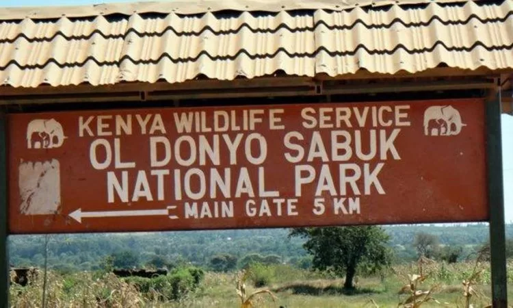
Oldonyo Sabuk ULTIMATE PANORAMIC EXPERIENCE “The Mountain of the Buffalo" A rugged hump-backed outcrop of ancient rockjutting high above the Athi plains and hazily visible from Nairobi. Ol Donyo Sabuk is densely forested mountain known to the local kikuyu as” the mountain of the buffalo. And to the maasai as ‘The big mountain’. Just one road leads to its summit, which offers magnificent 360’ panoramas over the Athi River. The pineapple fields Thika and the snow-capped peaks of both Mount Kilimanjaro and Mount Kenya. Within easy reach of Nairobi, the lush vegetation and cool air of this compact. And scenic National Park make for an ideal day trip or camping weekend. Oldonyo Sabuk A montane landscape The mountain's slope and ravines essentially comprise the park, and the entire area is forested except for a small area at the top. Within the halo of primal forest at the summit, you can also find some of the giant plants more commonly associated with the Afro-alpine zone of Mount Kenya and Mount Elgon, particularly giant lobelia. Driving to the summit The Park’s one road leads directly to the summit (4WD required all year round) a flat open glade marked by a large survey beacon. The summit is the focus of the park and offers breathtaking views, especially in December and January when the air is particularly clear. Walking to the summit Due to security reasons, the 9 km walk from the main gate (where 2WD vehicles can be left) to the summit was long prohibited. However, now it is possible to undertake the walk as long as an armed KWS ranger accompanies you. The walk to the summit will take approximately 3 hours. To avail the services of a KWS ranger, you must book through the warden and pay a small fee. An
Oldonyo Sabuk
ULTIMATE PANORAMIC EXPERIENCE
“The Mountain of the Buffalo”
A rugged hump-backed outcrop of ancient rockjutting high above the Athi plains and hazily visible from Nairobi. Ol Donyo Sabuk is densely forested mountain known to the local kikuyu as” the mountain of the buffalo. And to the maasai as ‘The big mountain’. Just one road leads to its summit, which offers magnificent 360’ panoramas over the Athi River. The pineapple fields Thika and the snow-capped peaks of both Mount Kilimanjaro and Mount Kenya. Within easy reach of Nairobi, the lush vegetation and cool air of this compact. And scenic National Park make for an ideal day trip or camping weekend.
Oldonyo Sabuk
A montane landscape
The mountain’s slope and ravines essentially comprise the park, and the entire area is forested except for a small area at the top. Within the halo of primal forest at the summit, you can also find some of the giant plants more commonly associated with the Afro-alpine zone of Mount Kenya and Mount Elgon, particularly giant lobelia.
Driving to the summit
The Park’s one road leads directly to the summit (4WD required all year round) a flat open glade marked by a large survey beacon. The summit is the focus of the park and offers breathtaking views, especially in December and January when the air is particularly clear.
Walking to the summit
Due to security reasons, the 9 km walk from the main gate (where 2WD vehicles can be left) to the summit was long prohibited. However, now it is possible to undertake the walk as long as an armed KWS ranger accompanies you. The walk to the summit will take approximately 3 hours. To avail the services of a KWS ranger, you must book through the warden and pay a small fee.
An unusual burial site
Along the road to the summit, you will find the grave of Sir William Northrup McMillan, a wealthy American farmer. They had to abandon the intended burial place on the summit when the vehicles accompanying his hearse burned out on the steep slope. Here also rests his wife, her maid and the family dog.
Wildlife watching
As the name suggests, the animals in the park are dominated by buffalo, which are often attracted to the salt lick below the summit. Additionally, it is easy to spot bushbuck in the park.
Leopards and porcupine are also in residence, but may prove more difficult to spot in the thick bush.
At certain times of the year, usually after the start of the rains, there is a colourful showing of butterflies on the mountain, particularly of the swallowtails and charaxes species. Within the park, it is sometimes common to see the relatively rare haraxes nandina.
Geology
0l-Donyo Sabuk is a remnant of Africa’s oldest erosion surface, generally regarded as late Jurassic. Lava (molten rock) escaped from fissures in the earth’s crust, forming the monotonous lava plateau of the Athi plains that surrounds the mountain. The lava gradually filled the valleys and smoothed the contours of the original landscape, leaving behind a residual hump of metamorphic rock.
The ‘Fourteen Falls’: while en route to the park take time to admire thika famous ‘ Fourteen Falls’. These are located half—way between Makutano and Ol Donyo Sabuk. The falls are sign posted to the leftjust before the bridge crossing the Athi River, and lie lkm, down a track.
WHERE T0 STAY LODGES, TENTED CAMPS
There is no lodge or tented camp in the park at the moment.
Self—catering accommodation
Sabuk House. This is KWS self-catering GuestHouse. The facility is fully furnished with a living room area, dining area, well-equipped kitchen, and conference room. It can accommodate up to 10 persons. You can make reservations through the Warden or KWS Headquarters. Nairobi.
Visitors can camp at the public campsite near the main gate. Facilities include picnic benches, water, latrines and showers.
Picnic Area
Visitor can picnic at the picnic site near the main gate or at lookout point which is at the mountain. At the point clients have an exellent view of Athi plains, Nairobi City, Thika industrial town, Ngong Hills and the expansive Kapiti plains of Kajiado District while enojoying the rest of the park.
WHEN T0 G0
All year round. After heavy rain, the road leading to the main gate may require a 4WD (four-wheel drive) vehicle.
WHAT T0 TAKE WITH YOU
Drinking water and picnic items (and camping equipment if you intend to stay overnight). Also useful are: camera, binoculars, hat, sunscreen, sunglasses, insect repellant and guidebook.
Nairobi History Nairobi, the capital city of Kenya, sits in the southern part of the country at an altitude of 1,660 meters above sea level. People consider it one of the most prominent cities in Africa, as it houses many multinational companies and organizations, including numerous UN bodies. Today, Nairobi is a cosmopolitan city attracting different ethnicities and nationalities, and has a population currently estimated at 3 million. The construction of the Mombasa to Kisumu railway played an important part in the development of Nairobi and is an indispensable element of its life and economy. The development of Nairobi as it is known today widely began with the arrival of the railway line at the site where Nairobi now stands on 30th May 1899. At that time, the city was just a bare open plain roamed by grazing wild game. The decision was made to construct a base for the railway workers before proceeding to the next phase of construction. Two months later, they transferred the railway headquarters from Mombasa to the site, and a railway town sprang up. There were no inhabitants, except the nomadic Maasai community. The Masai called this place Enkare Nyirobi, meaning the place of cool waters; the name has since changed to Nairobi. From 1899 to 1905, it served as the British provincial capital. In the year 1905, Nairobi became the capital of the British East Africa Protectorate and in the year 1963, it became the capital of independent Kenya. Today, Nairobi is a fine mixture of concrete and bush, and lives up to its billing as the CITY IN THE SUN. Vegetation surrounds the tall building structures in the city center, enhancing the beauty of this city. The surrounding areas are even greener, with beautiful architecture of buildings hidden within lush semi forest vegetation,
Nairobi
History
Nairobi, the capital city of Kenya, sits in the southern part of the country at an altitude of 1,660 meters above sea level. People consider it one of the most prominent cities in Africa, as it houses many multinational companies and organizations, including numerous UN bodies. Today, Nairobi is a cosmopolitan city attracting different ethnicities and nationalities, and has a population currently estimated at 3 million.
The construction of the Mombasa to Kisumu railway played an important part in the development of Nairobi and is an indispensable element of its life and economy. The development of Nairobi as it is known today widely began with the arrival of the railway line at the site where Nairobi now stands on 30th May 1899. At that time, the city was just a bare open plain roamed by grazing wild game.
The decision was made to construct a base for the railway workers before proceeding to the next phase of construction. Two months later, they transferred the railway headquarters from Mombasa to the site, and a railway town sprang up. There were no inhabitants, except the nomadic Maasai community. The Masai called this place Enkare Nyirobi, meaning the place of cool waters; the name has since changed to Nairobi.
From 1899 to 1905, it served as the British provincial capital. In the year 1905, Nairobi became the capital of the British East Africa Protectorate and in the year 1963, it became the capital of independent Kenya.
Today, Nairobi is a fine mixture of concrete and bush, and lives up to its billing as the CITY IN THE SUN. Vegetation surrounds the tall building structures in the city center, enhancing the beauty of this city. The surrounding areas are even greener, with beautiful architecture of buildings hidden within lush semi forest vegetation, adding to the freshness of the environment.
Where to visit
Famous Land Marks
Kenyatta International Conference Centre
For a modest fee the general public can travel up the interior of the conference centre tower in the high speed lifts to the 27th floor and walk the final three floors of stairs up to the roof for a bird’s eye view of 360 degrees of Nairobi City. For safety, there is a handrail around the perimeter. It has a helipad, the only one in the city on the top tier of the tower.
Besides viewing, it has become a haven for journalists, artists and performers who delight in the perfect photography and videoing angles it presents. Our local televisions run a number of local videos, and internationally aired documentaries have been shot atop the tower.
Dedan Kimathi Monument
They unveiled the life-size bronze statue of the Mau-Mau freedom fighter on Kimathi Street, opposite the Hilton Hotel, in Nairobi on the anniversary he was executed – February 18, 1957. Kimathi, clad in military regalia, holds a rifle in the right hand and a dagger in the other, symbolizing the last weapons he held in his struggle for the Nation’s freedom.
Tom Mboya Monument
The Tom Mboya Monument stands twenty meters from the location where the late Hon. Tom Mboya was murdered. It is located along Moi Avenue by the National Archives. They erected the monument in 2011 to honor the Kenyan Minister who was assassinated in 1969. The artist Oshottoe Ondula created the monument, and the government spent Sh15 million on its construction. The entire project, costing approximately Sh20 million, involved taking the monument to China, where it was cast in bronze.
Ngong Hills
This iconic range has been immortalized as ‘immovable waves against the sky’ in her novel turned Hollywood blockbuster” Out of Africa’ by Karen Blixen who had a farm on its foothills in the early 1900s. One can climb the five peaks of the mountain which the Maasai believe is the clasped fist of the giant who fell to his death here.
Nairobi National Park
The first national park established in Kenya in 1946, the 117km2 is the only wildlife park in the world where free ranging lions and rhinos share a city with humans. It is the only protected wildlife area in the world bordering a capital city and dubbed “The World’s only wildlife capital’.’
The park’s main gate is 10km from the city-centre and the fence runs parallel to the city. The Athi-Kapiti Plains and Kitengela migration corridors are unfenced and are important wildlife dispersal areas during the rainy season. Man—made dams within the park attract many animals and are important during the dry season.
Major wildlife attractions are the black rhino and the white rhino (not indigenous), lion, leopard, cheetah, hyena, buffaloes, giraffe, zebra, wildebeest, elands and 400 species of birds. Other attractions include the Ivory burning site Monument, Nairobi Safari Walk, the Orphanage and the walking trails at hippo pools.
How to get there
By road: 10km south of Nairobi City Centre.
By air: Jomo Kenyatta International Airport and Wilson Airports.
Park Gates
The park has 6 gates. Two gates are for KWS service use only
The gates are:
Main gate: KWS headquarters Langata road
Cheetah Gate
Langata Gate
Maasai Gate
Mbagathi Gate (service gate)
Banda Gate (service gate).
Climate
April-June and July-October are warm and wet. The rest are dry months.
Major Attractions
The only wildlife park in the world bordering a city It’s a must-do and best time to visit it is early morning or late afternoon. For more info log on to the Friends of Nairobi National Park (FoNNaP) website: www.fonnap.wordpress.com
Nairobi Animal Orphanage
Established in 1964, it is the oldest animal orphanage in Kenya and set in Nairobi National Park. It is a refuge and rehabilitation centre for wild animals found abandoned or injured in Kenya. Animals at the facility undergo a thorough medical examination, followed by treatment if needed, before entering into an appropriate feeding and rehabilitation program.
A green park amidst the high-rise buildings in the heart of Nairobi, it has an artificial lake and is a popular place for Nairobi residents to relax and for occasional political and religious gatherings. Freedom Corner was named after the Green Belt Movement founder and Nobel Laureate 2004 the late Professor Wangari Maathai for her efforts to protect public spaces in Kenya.
She famously fought former President Moi and his government to prevent a 62 storey skyscraper destroying the park — one of central Nairobi’s only public spaces. This was in the early 1990s during Moi’s dictatorship, which did not accept transgressions.
Central Park
Central Park is across the road from Uhuru Park whereas Uhuru Park is busy and exciting; Central Park is more relaxed and serene.
Sheldrick Elephant Orphanage
The orphanage is located within the Nairobi National Park, with the entrance on Nairobi to Kiserian Road, opposite the Kenya School of Communication Studies. lt is a centre for the rehabilitation and rearing of orphaned baby elephants. It was founded by Daphne Sheldrick in 1977 in honour of her late husband and famous naturalist, David Leslie William Sheldrick.
Daphne Sheldrick, his wife, continues his work of raising orphan elephants that have been brought to her from all over the country. The orphanage is a charitable organization, and is open to visitors daily between 11am and midday daily, when the baby elephants take their mud baths.
The Orphanage has a truly dedicated and experienced team that is committed to ensuring the survival of these animals and their successful reintroduction into the natural wild. The feeding time is truly interesting, with the baby elephants behaving just like babies, naughty, playing, and running around trying to catch the attention of everyone.
National Archives
The archives are located at the heart of CBD along Moi Avenue. It houses the Murumbi Gallery, dedicated to the late Joseph Murumbi, Kenya’s second vice-president from May 1965-August 31, 1966. He and his wife Sheila were avid collectors of African art.
Experts describe Murumbi’s collection as “Africa’s best-known collection of priceless heritage and artifacts!.” He left behind over 50,000 books and sheaves of official correspondence. The National Archives department has set up a library containing some of the 8,000 “rare books” (those published before 1900) entrusted to them upon the death of Murumbi.
Murumbi co-founded African Heritage with Alan Donovan, and it became the largest Pan- African art gallery on the continent. There is an extensive stamp collection of the Murumbis’ on the upper floor.
Murumbi turned down several huge bids from overseas bidders for his vast art collection and sold it instead to the Kenya government at a concessionary rate. He was specific that the collection be preserved at his Muthaiga home,which would become the Murumbi Institute of African Studies,with a library, hostel and kitchen upon his demise.
He died on June 22 1990 followed by his wife, in October 2000. They are buried outside the City Park cemetery near Pio Gama Pinto (March 31, 1927 – February 25, 1965) who was Murumbi’s mentor. Pinto, a journalist and politician was shot dead at a very close range, believed to be a political assassination.
The National Archives preserves public records.
Giraffe Centre
The Giraffe Centre started life as a refuge for the endangered Rothschild giraffe translocated from western Kenya. lt is the perfect location to see giraffes eye-to-eye and feed them with specially made hay-pellets, which they take from your hand using their sticky 25-inch long blue-grey tongues. Today there are about 1,500 Rothschild in Kenya with the biggest herd at Soysambu Conservancy on the shores of Lake Elementeita.
Nairobi Arboretum
The Arboretum, a 30-hectare green paradise in the city was established in 1907 by Mr. Batiscombe, then Deputy Conservator of Forests, to try out introduced forestry trees for Kenya.
Arboretum is under the management of the Forestry Department (FD). The Arboretum has over 350 species of indigenous and exotic plants. The diverse vegetation is also home to over 100 species of birds, a population of Sykes and Vervet monkeys, many butterflies and other small wildlife.
lt has beautiful paths for walking and jogging, and there are regular concerts held including tree-walks and talks by The Friends of Nairobi Arboretum. It is on Arboretum Road off State House Road.
For more information e-mail: fona@naturekenya.org
Ostrich Farm
Located in Langata, you can feed ostriches and watch them guard their gigantic eggs.
Uhuru Gardens
They raised Kenya’s first flag at that location on 12 December 1963. The national monument on Langata Road is Kenya’s largest memorial park. The park offers a tranquil picnic site, a popular family outing destination and a venue for corporate events. The Uhuru monument stands in it.
Nyayo Monument
Built in 1988 on Uhuru Highway to commemorate 25 years of independence, the marble monument shows the lowering of the British colonial flag and the raising of the Kenyan flag. It cost nearly a million dollars to construct.
Jomo Kenyatta Mausoleum
The mausoleum on the grounds of the Parliament in Nairobi’s CBD, is the final resting place of Mzee Jomo Kenyatta, Kenya’s first president who took up office as Prime Minister of the self—governing Kenya in 1963. A year later, Kenya became a Republic with Kenyatta as its first president.
Bomas of Kenya
The Bomas of Kenya is located just 10 km from Nairobi and about one kilometer up from the main entrance to the Nairobi National Park. This is an attractive and interesting exhibit of traditional homesteads of several Kenyan communities, complete with their inhabitants. Boma is a Swahili word for village, and these homesteads reflect the truly traditional architecture of the people.
They created them with the aim of promoting Kenyan culture.Over the years, the Bomas have become one of the leading attractions in the country. Visitors can take a leisurely guided tour of the homesteads, making this a good way to gain an insight into Kenyan culture. However, perhaps of more interest are the various performances of traditional dances and songs which are staged daily in a large circular theatre.
MUSEUMS
Nairobi National Museum, Snake Park and Botanical Gardens
The Nairobi National Museum has permanent and temporary exhibitions of its peoples, cultures, wildlife, prehistory and restaurants. A specific designated art gallery exhibits works by contemporary Kenyan and international artists.
The adjoining Snake Park has a large collection of reptiles and mammals. The Botanic Gardens and Nature Trail has the Kaya forest, grasses of Kenya and sculptures including medicinal plants. Located on the grounds of Nairobi National Museum is the office for Nature Kenya. Membership includes a Wednesday weekly bird walks around Nairobi, a day out within 100-km radius of Nairobi and occasional safaris. Log on to www.naturekenya.org. It is an affiliate of other nature groups in the country
Nairobi Gallery
Located right in the heart of Nairobi City next to the towering Nyayo House is the Nairobi Gallery. Built in 1913, this Old Provincial Commissioner’s office was fondly referred to as ‘Hatches, Matches and Dispatches’ because births, marriages and deaths were recorded here. The museum holds temporary exhibitions.
Karen Blixen Museum
The museum is located in Karen area, near the Karen Country Club.They set up the museum in 1985 on Blixen’s coffee farm at the foot of the Ngong Hills, and it still retains much of its original features. They have indeed well preserved the colonial farm house.
They have preserved much of the original furniture in its original state, including kitchen utensils, photographs, and original oil portraits painted by Ms. Blixen. Within the compound, they have a coffee-drying plant and small carriages that were used to ferry the coffee to the market.
In summary, Karen Blixen, the author of the famous book “Out of Africa,” which filmmakers adapted into a film in 1985, resided in the M’Bogani House from 1913 to 1931. She used the pen name Isak Dinesen. A Swedish settler built the house in 1911, and the Karen Coffee Company took over in 1913 when Bror Blixen purchased the Coffee Company for Karen. Right before the Karen Blixen Museum, they built the Swedo House in 1912 as the residence for the Swedish manager of the coffee plantation.
Experienced and well versed guides are available to take visitors through the house, with very detailed explanations about the history of Karen and her life.
Institute Of Primate Research Nature Trail
Tucked Within the Oloolua Forest a few minutes from Karen Blixen Museum is the institute of Primate Research’s nature trail. The indigenous forest has a spectacular waterfall, picnic site, caves, campsite and a viewing tower. The National Museums of Kenya helps to conserve and protect this valuable natural heritage for future generations. Enjoy a walk in the forest or a picnic. Entrance is strictly by prior arrangements with IPR or the National Museums of Kenya.
Where To Shop
Shopping Malls
Lifestyle – Location: Within CBD along Monrovia/Moktar Daddah Street
Galleria – Location: Along Langata rd, opposite Bomas of Kenya
The Junction — Location: Along Ngong rd
Prestige Plaza — Location: Along Ngong rd
Yaya Centre – Location: Along Argwing Kodhek rd
The Mall – Location: ln Westlands, along Waiyaki way
Sarit Centre – Location: In Westlands, Westlands/Parklands rd
Westgate — Location: ln Westlands, along Mwanzi rd
Village Market – Location: In Gigiri, along Limuru rd
Diamond Plaza – Location: In Parklands, along 4th Parklands Avenue
Africa Heritage
is a gallery and retail shop at the entrance to the Carnivore selling artifacts inspired by the designs of Africa. Also available are textiles, sculptures and arts of Africa as well as a clothing boutique and craft shop. Another feature of the shopping area is the GALLERY selling wrought iron sculptures by the internationally acclaimed local artist Kioko Mwitiki.
Maasai Market
is an open-air market ideal for African handicrafts, jewellery and souvenirs like beaded jewellery, batiks, baskets, sculptures, and paintings. It features at designated areas during the week.
The market is held in the following places:
Tuesday – Westgate shopping mall
Wednesday — Capital centre, along Mombasa rd
Thursday – The Junction shopping mall
Friday – Village market, Gigiri
Friday – Uchumi by Wilson airport
Saturday — Nairobi Law court grounds, CBD and Uchumi by Wilson airport
Sunday – Nairobi Law court grounds, CBD and Yaya Centre, Hurlingham
Where To Eat
Meat
The Carnivore-Nairobi
Nairobi’s old time favorite and internationally acclaimed, The Carnivore is a meat specialty restaurant and the ultimate ’Beast of a Feast’. The restaurant roasts whole joints of meat, such as legs of lamb and pork, haunches of exotic meat, rumps of beef, sirloins, racks of lamb, spare ribs, sausages, chicken wings, skewered kidneys, and even crocodile, and other tasty morsels. They roast them on traditional Maasai swords over a huge, spectacular charcoal pit that dominates the entrance of the restaurant.
The Simba Saloon at The Carnivore is for those who do not want to indulge in a large meal. lt serves pizzas (from a traditional, domed, brick oven), an extremely popular salad bar at lunchtime, steaks, hamburgers, scampi, trout, chicken, and other light snacks. It includes a nightclub from Wednesday to Sunday and has themed nights to cater for fans of contemporary African music, rock, soul, jazz and the latest hits.
Chinese and Japanese Restaurants
August Moon; situated at the food court, Westgate Mall.
Bamboo; situated at Zen gardens, Lower Kabete Rd.
Taste of China; situated inside the stylish Prime Apartments at the very end of Rhapta Road, Westlands.
Continental Restaurants
Alabaster Lounge
Half Past One Café
Jade Coffee and Tea House
French Cuisine Restaurants
Le Rustique
Ambiance Restaurant
Piano Bar at Captains Club Casino
Italian Restaurants
La Prudna D’oro.
La Grigla Restaurant.
La Dolce Vita.
indian Restaurants
Haandi Udupi.
Open House Karen &Westlands.
Anghiti Westlands & Muthaiga.
Arabian Restaurants
Café Habibi and Sheesha lounge.
Banks and Forex Bureaus
Barclays Bank
Equity Bank
Kenya Commercial Bank
Commercial Bank of Africa
Standard Chartered Bank
CFC Stanbic Bank
Co-operative Bank of Kenya
Family Bank
Consolidated Bank
Fina Bank
Gulf Bank
First Community Bank
National Bank of Kenya
Where to stay
Hotels
Mayfair Southern Sun Nairobi
Safari Park Hotel & Casino – Nairobi
The Anglican Church of Kenya Guesthouse
CENTRAL PROVINCE
Area: 13,191 km.
Lies North of Nairobi.
The 2009 census is 4,383,743 people in the province.
It has five counties: Nyandarua, Nyeri, Kirinyaga, Muranga and Kiambu.
The climate is cooler than the rest of Kenya, due to the region’s higher altitude. Rainfall is fairly reliable, falling in two seasons: one from early March to May (the long rains) and a second during October and November (the short rains).
Indigenous People: Bantu speakers who are mainly Agikuyu.
Nyeri County
Nyeri lies in the Central Highlands, 150 km North of Nairobi,straddling two mountain massifs -the western slopes of Mount Kenya and the eastern base of the Aberdare (Nyandarua) Range which forms part of the eastern end of the Great Rift Valley.
The colonial town of Nyeri was the centre of the Happy Valley settlers, a group of British aristocrats and adventurers who became famous for their infamous decadent lifestyles and exploits in the first half of the 20th century. The town retained little of an English village where the cool air and morning mists once attracted the Happy Valley settlers. The major industry in the county is farming due to its fertile soils. The area is one of the most densely populated in Kenya.
Main Attraction
Mt. Kenya National Park
Inscribed by UNESCO as a World Heritage Site, the 5,199 m mountain is the highest in Kenya and the second highest mountain in Africa after Kilimanjaro. It is 25 km from Nyeri town and 175 km from Nairobi. The highest peaks of the mountain are Batian (5,199 m (17,057 ft)), Nelion (5,188 m (17,021 ft)) and Point Lenana (4,985 m (16,355 ft)).
Mountain climbers must train and be acclimatized before climbing to reduce risk of high altitude sickness.
Best months to climb: January, February, August and September for the stunning views of the landscape.
What To Look For
Unique montane and alpine vegetation with 11 species of endemic plants, lakes, tarns and glaciers. Tree hyrax, bongo, white tailed mongoose, suni, black fronted duiker, giant forest hog, mole rat, bushbucks, water bucks and elands.
Rare forest birds.
Where to stay
KWS Self-Catering Accommodation at Batian Guest-house and Sirimon Bandas
Camping Facilities: Kinondoni, Road Head, Mintos Hut & Campsite, Naro Moru Gate, Met Station, Mackinders
Campsite, Austrian Hut, Sirimon, Judmaier, Shipton, Liki North Hut 7, Solo and Major public campsites
Common activities: hiking, bird watching, camping, sport fishing.
How to get there
From Nairobi to Nyeri approx. 150 km
Road
Nanyuki – lsiolo road via Sirimon track.
Nyeri — Nanyuki road via Naro Moru.
Chogoria via Embu – Meru Road.
Air
Mweiga Airstrip — 15 km from Nyeri town.
Nanyuki Airstrip — 25 km from Nyeri town.
Aberdare Ranges and National Park
Established in May 1950, the Aberdare National Park covers an area of 766 kml on the Aberdare Mountain Range between 7,000 ft (2,100 m) to 14,000 ft (4,300 m) above sea level. The park has stunning landscapes – from the mountain peaks to deep valleys with streams, rivers, and waterfalls. The mountains have moorland, bamboo and rainforests.
The two highest peaks are OI Donyo Lesatima (13,120 ft) and Kinangop at 12,816 ft. The park is 100 km north of Nairobi.
The Aberdare Range was named by J. J. Thomson in 1884 in honour of Lord Aberdare, who at that time was President of the Royal Geographical Society and the Royal Historical Society.
The Rhino Charge is an annual fund raiser to cater for fencing the Aberdare National Park as a means of protecting East Africa’s largest indigenous forest from destruction.
Major Attraction
Karuru Falls which are Kenya’s tallest waterfalls, Gura Falls, the Queen’s cave pavilion where in 1959, Queen Elizabeth ll and her husband, Prince Philip had a picnic, the 2nd largest population of black Rhino, freedom
fighter Dedan Kimathi’s hideout, the famous Kimathi post office in the fig (mugumo) tree and the Mau Mau freedom fighters caves.
Animals to look out for Black rhino, Colobus monkey, elusive forest antelopes like the bongo, 250 species of rare birds.
Activities
Picnics and camping in the moorlands, hiking in the forest, mountain climbing, sport fishing in the rivers.
Where to stay
Lodges
The Ark
Modeled on Noah’s ark, it offers superb 24-hour game viewing like the rhino coming to the salient in front of the lodge to lick salt and drink water.
The Aberdare Country Club
This beautiful country house hotel offers luxury accommodation. It is the base hotel for The Ark.
The Treetops Hotel
The Treetops Hotel is a world famous Hotel where a young woman ascended the stairs as a princess on 6th February 1952 and the following day, descended as Queen Elizabeth ll upon the death of her father King George IV.
KWS self catering accommodation
Fishing Lodge has two log cabins each with three bedrooms and two bathrooms to accommodate seven guests. Tusk Camp Banda has two bandas to sleep eight guests. Sapper Hut (wooden cabin) has two beds and an external bathroom. Kiandongoro Fishing Lodge.
In Park Accommodation
Treetops, The Ark and Aberdares Country Club.
Camping
Reedbuck — offers communal mess hut, pit latrine and shower.
Ruhuruini — offers pit latrines.
Wandare — no facilities.
Shamata — no facilities.
Other places close to Nyeri to stay
The luxurious Mt Kenya Safari Club.
Naro Moru River Lodge (The base for climbing Mt. Kenya).
Mountain Lodge Serena.
Outspan Hotel.
Sandal Homestay and Cottages.
Colobus Cottages.
Paxtu House
Paxtu House is a small museum standing on Outspan Hotel grounds. The house was built for Lord Baden Powell, the founder of the scouts’ movement in the world. Room 45 of the hotel was his bedroom and has been converted into a scout’s museum.
Lord Baden Powell’s grave site is a national monument.
Events in Nyeri County
Mwea classic marathon
Founders day -Scouts event February 22
Kiambu County
Kiambu is an administrative district in the Central Province and borders Nairobi. Although the county is rural, its urban population is increasing as Nairobi grows rapidly.
The main economic activity in the county is agriculture- tea, coffee, dairy, poultry and horticulture. Kiambu’s major urban centers are Thika, Ruiru, Gatundu, Limuru, Kabete, Githunguri, Kiambaa, Kikuyu, Kiambu, Lari and Karuri.
Attractions in Kiambu
Chania Falls and Thika Falls: Both falls lie on either side of the iconic Blue Posts Hotel in Thika.
Fourteen Falls
The falls are located about 65 km from Nairobi off the Thika – Garissa Road. The name is from the fourteen successive falls of water along the famous Athi River, originating from the Aberdare mountains. They form the border between Thika and Machakos districts.
How to get there
21 km from Thika town. Take Thika-Garissa road, turn at Makutano Junction. At the base of Fourteen Falls are large boulders with water cascading 25-feet down.
Where to stay
Fourteen Falls Lodge
Blue Post Hotel.
Activities
Boating, fishing, photography, and bird watching. However the water is polluted so water activities are done at your own discretion.
Kilimambogo:
Near the Fourteen Falls lies Kilimambogo, a Swahili word for the Mountain of the Buffalo and home to the late Great philanthropist Sir Macmillan. Half way up the hill, you will find the graves of Sir Macmillan, his wife and their house help. It is on the foot of this hill that Macmillan entertained Theodore Roosevelt, former President of the United States, and Sir Winston Churchill, former Prime Minister of the United Kingdom.
Thika World War Memorial Park
This park along General Kago road is the final resting place of the souls of gallant African Soldiers.
Mama Ngina Gerdens
These gardens along Mama Ngina Drive boast walkways and public lawns for leisure walks and picnics.
Kirinyaga County
Kerugoya is the main administrative town in Kirinyaga County. The county has four constituencies namely; Mwea, Gichugu, Ndia and Kirinyaga Central. The main economic activity in the area is agriculture.
Attraction
Mwea National Reserve
The 42 kml reserve is northwest of Kamburu Dam, a little known oasis.
Animals
Elephants, lesser kudu, crocodile, hippo, giraffe, Burchell’s zebra, buffalo, leopard, grey duiker, black-backed jackal bushbuck, waterbuck, Olive baboon, Sykes’ monkey, Serval cat, Spotted hyena, warthog, rock hyrax, bush pig, impala and hartebeest. Rare animals include stripped ground squirrel, genet, black backed jackal, and yellow baboons.
Birds
Over 200 species of birds, Mwea is renowned for its water birds and waders. The only protected area for the globally threatened and Kenya-endemic Hinde’s babbler, the reserve shelters two other rare species – the Pel’s fishing owl and the White-backed night heron.
Activities
Game drives
Water rafting and bungee jumping in the Tana River.
How to get there
Road
170 km from Nairobi with the last 10km on dirt road. Take the Thika road to Matuu
– Masinga Dam – Makima Gate.
Air
Masinga airstrip near Masinga Lodge. Then a 13km drive to the reserve via Makina Gate.
Where to stay
No lodges or self-catering accommodation in the reserve.
Masinga Lodge is outside the reserve at Masinga Dam.
Camping Facilities
Mbogo, Silvester, Mavuria, Kyangosi, HippoPoint, Kanyonga and Githechu.
Park operation hours: 6.00am-6.00pm including holidays.
Water rafting and bungee jumping in the Tana River.
Where
Bungeewalla
How
This is done along the banks of River Tana where participants jump off a 60 m (200 ft) high, custom built tower erected on the banks of the river. Jumpers ascend the tower attached to a safety rail specialized climbing harnesses. Once on the top, they are fitted with the bungee cord, and are then free to take the plunge over the wild waters.
The weight restrictions are a minimum of 40kg and a maximum of 110kg.There is no age restriction. Each person takes an average of 15 mins in the jump cage. As insurance and precautionary measure, each jumper has to sign a release and assumption risk form.
Great Rift Valle Province
The Great Rift Valley is the continuous geographic trough, about 6,000 km long, that cuts through Africa and runs from Syria in North West Asia to Mozambique in Eastern Africa. The name was given by the late 19th century explorer John Walter Gregory.
Scientists say that the Rift Valley was formed about 20 million years ago when the earth’s crust weakened and tore itself apart creating the jagged rift across the African continent. During this phenomenon, great volcanic mountains were formed by eruptions on either side of the valley, while the valley floor gradually sank into the flat plain as it is known today.
The Great Rift Valley divides Kenya down the length of the country. The width varies from about 100 km to its narrowest width of about 45 km just north of Nairobi. The depth of the valley floor also varies, being at the lowest near the Lake Turkana.
Apart from the Rift Valley itself, the area has other important geographic features such as the extinct volcanoes, Mount Longonot and Mount Suswa, Lake Baringo, Lake Bogoria, Lake Magadi, Lake Nakuru, Lake Naivasha, the Suguta Valley and Lake Turkana.
Rift Valley is the largest province in the country. The province covers an area of 173,854 square km (42,960,000 acres), and has 13 counties namely; Turkana, West Pokot, Samburu, Trans-nzoia, Uasin Gishu, Elgeyo Marakwet, Nandi, Baringo, Laikipia, Nakuru, Kajiado, Kericho and Bomet.
Turkana County
Turkana County in north—western Kenya borders Marsabit County to the east, Samburu County to the south-east, and Baringo and West Pokot Counties to the south. Lodwar Town is the county’s headquarter.
Attraction
Lake Turkana
This is the world’s largest permanent alkaline desert lake located in the north-western part of Kenya and covering an area of 6,405 square km. Its northern tip crosses into Ethiopia and is fed by three rivers – the Omo of Ethiopia, the Turkwel and the Kerio. The lake is also called the Jade Sea because of its azure-green colour from algae in bloom.
Lake Turkana became known after Count Teleki’s expedition struggled over incredibly barren and inhospitable terrain and reached its shore on 6th March 1888. Teleki named his discovery Lake Rudolf to honor the Crown Prince of Austria. In 1975 the Kenya Government changed the name to Lake Turkana to honor the lakeshore people.
Activities
Sport fishing
Sailing
Island hopping
Central Island National Park
The island park in Lake Turkana is 5km2. Central Island has three scenic crater lakes – Crocodile, Flamingo and Tilapia and an active crater.
How to get there
Road: 800km from Nairobi to Lake Turkana, then take a boat from Sibiloi National Park or from Lodwar. Access from Nairobi is on the main Nairobi – Moyale road or from Maralal to Loiyengalani through Baragoi and South Horr.
By Air: Two airstrips at Sibiloi
Atractions
Three crater lakes – Crocodile Lake, Flamingo Lake and Tilapia Lake and an active volcano.
Loiyangalani Desert Museum
The museum on a hill overlooks Lake Turkana. Opened in 2008, it focuses on the lives of the eight communities living in the area and on the natural environment in this harsh country. The eight communities are Turkana, El-molo, Rendille, Samburu, Gabbra, Watta, Boran and Dassanash (Merillle).
Koobi Fora
The site with a museum lies on the eastern shores of Lake Turkana. Koobi Fora is one of the world’s leading pre-historic sites for the study of human evolution. In 1972 the area was gazetted as Sibiloi national park and is a World Heritage Site since 1977.
Sand Dunes
The sand dunes are best enjoyed in a four-wheel drive adventure to an oasis surrounded by palm trees. The dunes measure over 40 feet high with breathtaking sceneries.
SIBILOI NATIONAL PARK
Dubbed “The Cradle of Mankind”. It lies on the northeastern shore of Lake Turkana about 800km from Nairobi. The semi-desert ecosystem was established to protect its petrified cedar forest, wildlife and the unique prehistoric and archaeological sites linked to the origin of man.
The park is waterless except for the alkaline lake. It is nonetheless rich in wildlife such as zebra, giraffe, hippo, crocodile and numerous bird species such as flamingos, pelicans and ducks. Other attractions are the preserved wildlife fossils, which include the Giant Tortoise and the 20-foot long crocodile.
How to get there
By Air: There are two all weather strips.
Gates: One gate
Roads: High-clearance 4WD is essential all year round. Travel in convoy is recommended.
The lake is a three-day continuous drive from Nairobi via Marsabit and North Horr. The other route is Maralal via South Horr. lt’s best to take a few extra days to enjoy stops enroute. Alternatively travel by road from Nairobi to Kalokol on the lake’s western shores, via Kitale and Lodwar. From Kalokol, boat hire services are available across the lake to Allia Bay.
Climate
Scorching hot and arid (especially December-March). June and July are the coolest months. May-September very strong winds blow most of the day. Rainfall is less than 250mm per annum.
Major Attractions
Origin of man: Koobi Fora museum and research base
The tempestuous ‘Jade Sea’
Petrified forests
Prolific birdlife
Crocodiles
Wildlife
Zebra, Grant’s gazelle, Reticulated Giraffe, Beisa oryx, topi, Greater kudu, hippo, lion, cheetah, leopard, Striped hyena and Silver-backed jackal. The world’s largest Nile crocodile population breeds on Lake Turkana’s Central Island.
Where to Stay
Loyiangalani (south tip of Lake Turkana)
Oasis Lodge
Lobolo Tented Camp
Palm Shade (bandas and campsite).
Self — Catering Accommodation
Allia Bay Guesthouse: offers 3-double bedrooms, solar generated electricity and furnished indoor sitting, dining and kitchen.
National Museum of Kenya, Koobi – For a research base and campsite.
Lake Turkana Lodge.
Camping
Two public campsites:
Turkana campsite, and
Koobi Fora Campsite
Activities
Game drives
Camping
Archeological safaris
Bird watching
Swimming
Fishing
WEST POKOT COUNTY
Kapenguria is the county’s capital town and home tithe infamous Turkwel Hydro-electric power plant which serves the national grid with approximately 105MW of power.
Attraction
Kapenguria Museum
Kapenguria museum reflects Kenya’s political history. The infamous Kapenguria trial of Mzee Jomo Kenyatta, Kungu Karumba, Fred Kubai, Paul Ngei. Bildad Kaggia and Hon. Ramogi Achieng Oneko was held in Kapenguria. The six leading Kenyan nationalists were arrested in 1952, tried at Kapenguria in 1952-3, and imprisoned thereafter in Northern Kenya. All of them have since passed on.
SAMBURU COUNTY
This county borders Baringo County to the west, Laikipia County to the south, lsiolo County to the East and Turkana County to the northwest and Marsabit County to the north.
Maralal town is its headquarters
ATTRACTIONS
Samburu Game Reserve
Located on the banks of the Ewaso Nyiro River and neighbors Buffalo Springs National Reserve on the opposite bank. It covers 165km2 and 350km from Nairobi.
In the middle of the reserve, the Ewaso Ng’iro flows through doum palm groves and thick riverine forests that provide water without which the game in the reserve would not survive. The Samburu National Reserve was one of the two areas in which conservationists George Adamson and Joy Adamson raised Elsa the Lioness, made famous in the best-selling book and award winning movie, Born Free and its sequels. The Samburu National Reserve is also the home of Kamunyak (the blessed one), a lioness who adopted six oryx calves between 2002 and 2003.
Buffalo Springs National Reserve
Buffalo Springs National Reserve is separated from the Samburu National Reserve by the Ewaso Ngiro river. It is less hilly and less dense than Samburu but equally attractive. Buffalo Springs takes its name from an oasis of clear water at the western end of the sanctuary. The Reserve is 131 km and lies on the leeward side of Mount Kenya, rarely receiving rain. During the struggle for independence in Kenya, Mau Mau freedom fighter hid in the park. The legendary Mau Mau General Mathenge passed through when fleeing to Ethiopia. There is a pool of spring water caused by bombing during the 2nd World War by European forces.
Attractions
365 species of birds, Reticulated giraffe, Grevy’s zebra, elephant, Beisa Oryx, Somali ostrich, hippo, crocodile, gerenuk, buffalo, lion, leopard, cheetah, hyena, spring pool.
Activities
Bird watching
Hiking
Camping
Game drives
Shaba National Game Reserve
The remote reserve in north Kenya is rugged wilderness featuring hot springs, rolling savannah, miles of scrub and desert, a waterfall and the Ewaso Ngiro River which supports a diversity of wildlife. This reserve was established in 1968. A solitary mountain rises to 2,145m from an otherwise flat area.
Attractions
Gravy zebra, the Somali ostrich, gerenuk, the Reticulated giraffe, gazelles, Lesser kudu, leopard, lion, elephants and bird life.
How to get there
Road: 314km from Nairobi
Air: 45 mins flight.
Activities
Bird watching
Hiking
Camping
Game drives
Where to stay
Many hotel chains have their presence in the county – Sarova Shaba (in Shaba), Samburu Serena, Larsens Camp, Samburu Lodge, Samburu Intrepids among others.
It borders Turkana County to the North, Samburu and Laikipia County’s to the East, Koibatek to the South, Keiyo Marakwet and West Pokot to the West. The county covers 8,655km2. It is part of the Great North Rift initiative.
Email: greatrift.outdoor@gmail.com
Attractions in Baringo
Torok and Kessup water falls in Keiyo County, Arror and Embobut in Marakwet County.
Rondinin (Simut) and Kipngochoch cliffs in Baringo county and Kamriny in Keiyo county.
The Great Rift Valley (Kerio valley and Suguta valley).
Cherangany hills in Marakwet and West Pokot county, Elgeyo Escapement in Keiyo county, Seker hills in West Pokot county, Tugen hills in Baringo County and Mogila hills in Turkana county.
Turkwel Gorge in West Pokot county and Chebloch in Baringo and Keiyo county
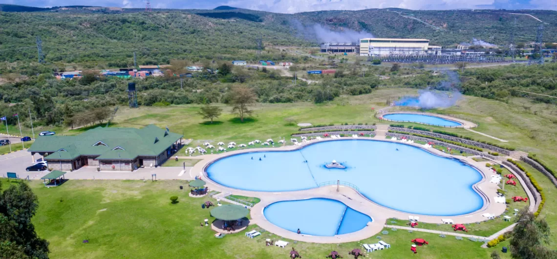
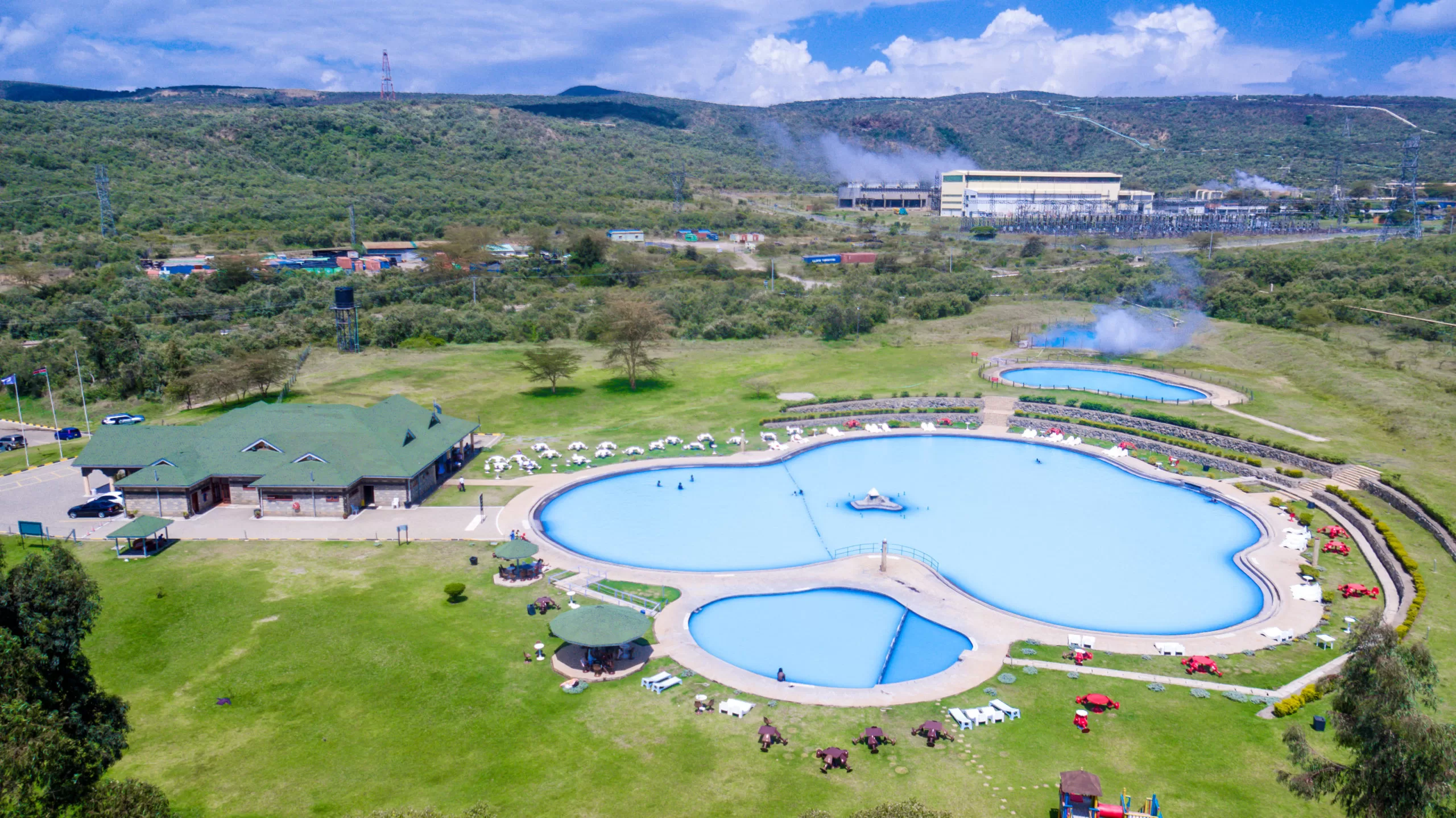
Lake Bogoria in Baringo County is a popular tourist attraction site because of its active geysers. The geysers produce steam rich in sulphur compounds, believed to be medicinal.
Paragliding.
LAKE BARINGO
Lake Baringo is in the northern Great Rift Valley with a surface area of about 130km2. The lake is fed by two rivers – El Molo and Ol Arabel and has no obvious outlet, despite it being one of the two freshwater lakes in the Rift Valley, the other being Lake Naivasha. It lies off the beaten track in a hot and dusty setting. Over 470 species of birds have been recorded here, including migrating flamingos.
Ruko Conservancy
Ruko Conservancy is a 19,000-hectare-area to the north and east of Lake Baringo, consisting of bushland and about 10km of shoreline. lt includes the former ll Chamus village of Longicharo at the northeastern corner of the lake, which has now been abandoned. The Conservancy was started in 2004 with the aim of bringing peace between the neighboring communities of the Pokot and ll Chamus (Masai) who often dashed over grazing rights.
Reserves
Lake Bogoria
Lake Baringo
Lake Kamnarok
Lake Nasolot
Saiwa swamp
Lake Rimoi
Lake Turkana
MARALAL
The gateway to Kenya’s northern wilderness. A small hillside market town in northern Kenya, lying east of the Loroghi Plateau within the Samburu District
Activities
Camel derby in July and August
Camel safaris
Wilfred Thesiger’s house — early 20″‘ century explorer
Maralal national park
Where to stay
Maralal Safari lodge
Bobong Campsite (www.Iaikipiatourism.com)
LAIKIPIA COUNTY
Laikipia county has two major urban centres: Nanyuki to the. southeast and Nyahururu to the southwest. Log on to Laikipia Wildlife Forum,” www.laikipia.org, for an updated version of places to stay, activities. and latest wildlife projects. It is a dynamic, community-based organization, membership led conservation organization.
NANYUKI
Nanyuki is a market town in central-east Rift Valley region of Kenya lying northwest of Mount Kenya along the A2 Road and at the terminus of the branch railway from Nairobi. It is situated north of the Equator (0° 01‘ North). Founded in 1907 by British settlers, it is the main airbase of the Kenya Air Force.
The British Army has a base at the Nanyuki Show Ground (NSG) from where it conducts yearly desert and jungle training exercises on the mountain and in the arid areas to the north. Nanyuki is the capital of Laikipia County. The Equator passes through the southern part of Nanyuki.
Climbers and backpackers visit Nanyuki on their way to or from Mount Kenya along the Sirimon: and Burguret routes and many other tourists pass through the town.
Where to stay
Lion’s Court, Equatorial Hotel, Mount Kenya Paradise Hotel and Joskaki Hotel. Mount Kenya Safari Club and Sportsman’s Arms Hotel are best known.
Where to eat
The Marina
Nakumatt, the mega supermarket with branded cafes and restaurants
The Trout Tree Restaurant is a stunning restaurant wrapped around an ancreat fig tree serving fresh trout from its ponds
“Barneys” at Nanyuki Civil Airfield once the base of the N°. 1340 Flight RAF, which flew Harvard’s during the Mau Mau Uprising.
How to get there
Nanyuki can be reached by air. The airport lies 6.5km’ (4miles) south of the town and is served by regular air services from Wilson airport.
The town is reachable using the all weather road from Nairobi.
Attractions
Tourists can visit a number of parks and reserves around Nanyuki. The most popular is Mount Kenya National Park. Others are Ol Pejeta Conservancy, Lewa Wildlife Conservancy, Samburu National Reserve, Buffalo Hills National Reserve, and Shaba National Reserve.
NYAHURURU
In 1883, the intrepid explorer Joseph Thomson saw the 70m high waterfall on the Ewaso Ngiro River — which flows from the Aberdare Mountains – after a night on the Aberdares and named them Thomson’s Falls after himself. It was the founding of modern-day Nyahururu. Nyahururu is on the junction of Nyeri-Rumuruti Road and the Nyeri- Nakuru Road. The town grew around a railway from Gilgil opened in 1929.
Attractions
Thomson’s falls: is a 70m scenic waterfall on the Ewaso Narok River, which drains from the Aberdare Mountain Range.
KAJIANDO COUNTY
Amboseli National Park
How to get there
By Road:
From Nairobi via Namanga (240km) on the Nairobi – Arusha Road, through Meshanani Gate.
From Nairobi via Emali (228km) on the Nairobi – Mombasa Road through Remito Gate.
Access from Mombasa is mainly through Tsavo West National Park via Kimana (Olkelunyiet) Gate.
By Air:
The park has a single airstrip for light aircrafts at Empusel gate, Kilimanjaro Buffalo Lodge and Namanga town.
Park Gates
Olkelunyiet Gate
Meshanani Gate
Kitirua Gate
Remito Gate
Airstrip Gate
Climate
Temperature ranges from 20—3O°C and rainfall from 200mm – 700 mm.
Two rain seasons:
Long rains — March and April.
Short rains — November and December.
MAJOR ATTRACTIONS
Large Herds of Elephants — the pachyderms of Amboseli are the longest studied elephants in the wild since the early 1971.
Mt. Kilimanjaro
Big Five
Observation Hill for an aerial view of the park with its swamps, dust plains and Mt Kilimanjaro.
Swamp below Observation Hill which is frequented by elephants, buffaloes, hippos and water fowls like pelicans and Egyptian geese.
Maasai culture.
WILDLIFE
Leopard, cheetah, Wild dogs, buffalo, elephant, giraffe, zebra, lion, plains game, crocodile, mongoose, hyrax, Dik- dik, Lesser kudu and others Prolific birdlife with approximately 600 species
NAKURU COUNTY
Nakuru, the provincial capital of Kenya’s Rift Valley province, with 300,000 inhabitants, is the fourth largest urban centre. it is 1,850m above sea level.
The County covers a vast area including towns like Naivasha, Gilgil, Nakuru, Molo and Njoro.
NAIVASHA
Naivasha, for the last two decades is more associated with the flower farms than the pristine freshwater lake it is home to. Situated 90 kilometres from Nairobi, it’s an hour’s drive through the Great Rift Valley. Lake Naivasha is ideal for bird watching and exploring the shores where wildlife is found in private sanctuaries and Elsamere, once the home of Joy and George Adamson of the Born Free fame.
Common camping sites in Naivasha include:
Fisherman’s camp
Camp Carnelleys
Crayfish
Crater Lake camps
KWS Hippo Camp
Hell’s Gate National Park
A walk on the wild side Hell’s Gate National Park lies south of Lake Naivasha, Northwest of Nairobi. The stunning park is‘famous for its natural rock towers scaling high, cliffs, flat plains and eroded gulleys.
Olkaria and Hobley’s are two extinct volcanoes located in the park. in the Hell’s Gate Gorge, lined with red cliffs are two volcanic plugs: Fischer’s Tower and Central Tower. The Central Tower is the smaller gorge, which extends to the south where a path descends into the hot springs.
It has abundant plains game such as buffalo, zebra, eland, hartebeest, giraffe, baboons, Thomson’s gazelles, the rare Chandlefs mountain reedbuck, lion, leopard and cheetah. Over 100 species of birds have been recorded including vultures, Verreaux’s eagles, augur buzzard and swifts. The cliffs once hosted the now almost extinct population of the Lammergeyer or the bearded vulture that used the cliffs to drop animal bones from a height to break them open and scoop out the marrow. The cliffs are home to a shy antelope, the Klipspringer that is adapted to living on the rocks.
In June, KWS organizes the wheelbarrow race in the park as a fund raising activity. It is a fun day out for the family (check www.kws.go.ke for details).
How to get there
Road: The park is accessible via tarmac road from Nairobi (90km) via Naivasha Town on the Lake Road South at a junction 5km south of Naivasha.
Air: Naivasha airstrip
Park Gates
Elsa Gate
Olkaria Gate
Cimate
Temperature ranges from 20-30°C and rainfall from 200mm – 700 mm
These is no accommodation in the Park; although a wide
of accommodations options are available in Naivasha
town and along Moi South Lake Road.
Camping Facilities
Oldubai campsite (on the cliff top south of Fischer’s Tower).
Nairburta campsite.
Endchata campsite (across the gorge on the northern cliffs).
Mt. Longonot National Park
The mountain park is coined “Sheer adventure”
Distance:
90km from Nairobi enroute to Naivasha and close to Hell’s Gate National Park.
The park is the mountain, which rises 2,776m above sea level (9,l08ft). The dormant volcano on the floor of the Rift Valley has ridges with little vegetation but the yawning crater
How to get there
90km on tarmac road from Nairobi.
Climate
Temperature ranges from 20-30°C and rainfall from 200mm – 700 mm.
Major Attractions
Extinct volcano and crater forest, scenic landscape, views of lake Naivasha, Mount Eburru, Mount Suswa and the Great Rift Valley.
Wildlife
Buffalo, eland, lion, leopard, bushbucks, common zebra, giraffe, Grant’s gazelle, Thomson’s gazelle and many other antelopes.
Where to stay
In – Park Accommodation
There is no accommodation in the Park. A wide range of accommodation is available in Naivasha town and along Moi South Lake Road.
KWS Self – Catering Accommodation
There are no self-catering facilities at Hell’s Gate National Park.
Camping Facilities
Olongoonot campsite
Osotua Cottages and Campsite on the base of the lower escarpment road. Osotua means peace in Maasai language. It is a community initiative between the local Maasai and Kikuyu
Activities
Hiking on the mountain
Biking
Bird watching
Wildlife watching
Best Time To Visit
All year round
Lake Naivasha
The freshwater lake northwest of Nairobi, outside the town of Naivasha, lies in the Great Rift Valley. The name is derived from the local Maasai name Nai’posha, meaning “rough water”.
The lake is approximately 139km2 and is the highest of the Rift Valley lakes at 1,884m (6,180ft). Much of it is surrounded by flower farms and increasingly, by fewer swamps. It is nevertheless pristine and rich with birdlife.
The lake has an average depth of 6m (20ft), with the deepest area being at Crescent lsland, at a maximum depth of 30m (100ft). Njorowa Gorge used to form the lake’s outlet, but it is now high above the lake and forms the entrance to Hell’s Gate National Park.
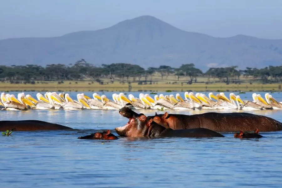
The lake is home to a variety of wildlife with over 400 species of bird. There is a sizeable population of hippos in the lake. There are two smaller lakes in the vicinity of Lake Naivasha: Lake Oloiden and Lake Sonachi (a green crater lake).
NAKURU TOWN
Menengai Crater
Located eight kilometres from Nyahururu – Nakuru main road.
Menengai Crater, a dormant volcano is the second largest crater in the world and plunges 483 metres from the rim.
The volcano was formed about 200,000 years ago. The 12 x 8 km caldera formed 8000 years ago. Menengai is one of the best-preserved calderas in the world. The crater floor is ideal for hiking. The summit is accessible by foot or vehicle. There is geo—thermal prospecting in the crater for energy.
Attractions
Crater walk
Few places in Kenya to see the South African National flower, the Protea growing wild
Bird watching
Where to Stay
Maili Saba on the rim of the crater – a simple tented camp with stunning views of the crater
Lake Elementeita
Located 40km from Nakuru along the Nairobi-Nakuru highway. It is a World Heritage Site since the year 2011.
The alkaline lake is i8km2 in size and lies on the eastern side of the Great Rift Valley. Most of it is in the Soysambu Conservancy. The lake is an important site for Great white pelicans, flamingos and other waders. The conservancy has the biggest population of the endangered Rothschild giraffe.
Attractions
Flamingos
Great white pelicans
Great crested Grebe
Rothschild giraffe
Aardvark (nocturnal)
Activities
Game drives
Horse riding
Bird watching
Visit to the natural hot springs
Where to stay
Lake Elementeita Lodge
Lake Elmenteita Serena Camp
The Sleeping Warrior Camp
The Sleeping Warrior Lodge
Museums
Kariandusi Site
Two kilometres east of Lake Elementeita skirting the diatomite mine along the Nairobi-Nakuru highway, the acheulian site has hand axes and cleavers including fossils of extinct animal species. A nature trail leads you through the site once part of a bigger lake.
Hyrax Hill Museum
The museum atop a hill was once a colonial farmhouse. Ancient dwellings of the Sirikwa people now extinct are found in-situ the oldest dating to 3,000 years and the youngest to possibly 300 years. The museum displays ethnographic materials of the people in the Rift Valley, archaeology and local ecology. The nature trail is a must-do for an aerial view of Lake Nakuru and the town.
Olorgesailie Prehistoric site
This acheullian site is 90kms southwest of Nairobi on Magadi road. Its in-situ displays of pre-historic materials including numerous hand axes, fossilized skeletons of extinct species of elephants and hippopotamus dating back from 1.2 million years ago. Other attractions include a museum, campsite, bandas and nature trail.
Bookings through the National Museums of Kenya (www.museums.or.ke).
Lake Nakuru National Park
140km northwest of Nairobi, the park lies in Central Kenya in Nakuru district of the Rift Valley Province. The alkaline lake has a crusty shoreline, surrounded with wooded and bushy grasslands. Famous for its flamingos (Greater and Lesser) that turn the shoreline crimson including 450 species of birds. The park is rich in wildlife with both species of rhinos (the black and the white), buffalo, lion, leopard, Spotted hyena, baboons, Vervet monkeys and wildebeest.
Lodges
Lake Nakuru lodge.
Sarova Lion Hill Lodge.
Flamingo Hill Tented Camp.
Self-Catering
Wildlife Clubs of Kenya hostels and house.
KWS Naishi house.
Special Campsites
Naishi, Chui, Rhino, Soysambu, Nyati, Nyuki and Reedbuck.
Wildlife Clubs of Kenya campsite.
Public Campsites
Makalia and Backpackers.
ACTIVITIES
Game drives
Bird watching
Camping
MAJOR ATTRACTIONS
Flamingo (Greater and Lesser), Great white pelicans and other water birds including a variety of terrestrial birds numbering about 450 species.
Mammals: 56 different species including black rhinos, white rhinos, lions.
View-points: Lion hill, Baboon cliff and Out of Africa..
Hills: Enasoit, Honeymoon, Lion hill ridge.
Waterfalls: Makalia.
Vegetation: About 550 different plant species including the largest euphorbia forest in Africa; yellow acacia woodlands.
Cycle with Rhino fund raising event every September.
How to get there
Road: 156km northwest of Nairobi, the park is on the main A104 tarmac road. The most commonly used route into the park is via the main gate, 4km from Nakuru town centre. It is also possible to enter the park from the main Nairobi-Nakuru road, or Lanet Gate. The Nderit Gate when driving in from Masai Mara or Elementeita.
By Air: Naishi airstrip
PARK GATES
The park has three gates: Main Gate and Lanet Gate that link the park with the Nairobi-Nakuru highway and the less used Nderit Gate.
NJORO TOWN
Lord Egerton Castle
The castle at Ngata, 14km from Nakuru town is on a 100- acre piece of land. Built by Lord Egerton for his bride-to- be in 1938 it was completed in 1954 after she rejected his wedding proposal stating that the house he lived in then (a six bedroom house) was as small as a chicken coop. The heart-broken Lord Egerton never married, never wanted to see another woman and banned all women on his property.
He died in 1958. The castle was built by 100 lndian labourers using imported material and some local from the nearby Kedowa and Njiru. The marble and tiles were imported from Italy and England. Today the castle belongs to the Egerton University and is open to tourists.
KERICHO COUNTY
The Mau Forest in Kericho is the biggest water catchment area in Kenya. At a high altitude and virtually daily rains, Kericho is the centre of Kenya’s large tea industry. Some of the biggest tea companies including Unilever Kenya, James Finlay and Williamson Tea are based here. It is also home to the popular Ketepa brand. Much of the tea is exported, with the UK being the largest market. The district is home to some of the world’s best long distance runners.
Attractions in Kericho
Tea farms and factories
Chagaik dam
Chagaik botanical garden on the Kericho—Nakuru highway, 10km from Kericho.
Where to stay
Tea Hotel Kericho — old colonial hotel a bit neglected but still beautiful.
Saiwa Swamp National Park
The three-square-kilometre park is 385km from Nairobi and 27km from Kitale town in Trans-Nzoia District, Rift Valley Province. The park has forests and swamp. The swamp is dominated by tall bull-rushes and sedges and is bordered by open grasslands and riverine forests. The park was established to protect the endangered Sitatunga, a semi-aquatic antelope. Other wildlife species commonly found in the swamp include the Otter, Genet cat, Serval cat, mongoose, bushbuck and monkeys. It’s rich in birdlife, with 372 species.
Attractions
Annual Wildebeest Migration from the Serengeti into the Mara from June to October This is a huge tourist attraction that brings droves of tourists to The Mara. From June onwards, the animals travel over 960km (600 miles) from Tanzania’s Serengeti plains, northwards to the Masai Mara and the Mara River is the final obstacle. In October or November, once they have feasted on the tall grass, they leave for the Serengeti. More than 1.3 million wildebeest, 500,000 Thomson’s gazelles, 200,000 zebras, 97,000 topi and 18,000 eland migrate with the big cats and the vultures in tow. The herds are ruthlessly preyed upon by prides of lions that track them across the wilderness, and by the crocodiles that lie in wait as the animals cross the Mara River.
Also regularly seen are hyenas, Silver-backed jackal and Bat-ea red foxes.
Black rhino are a little shy and hard to spot but are often seen at a distance.
Hippos are abundant in the Mara River as are Nile crocodiles, who lie in wait for a meal.
Narok Museum
This museum is situated in Narok Town. It depicts a scanty insight into the otherwise fascinating culture of the Maasai and other speakers of the Maa language.
Western Province
Western Kenya boasts of farm county with evergreen vegetation, beautiful rolling hills, and vast maize, sugarcane and tea plantations. The region borders Rift Valley and Nyanza, with Kakamega town being the provincial headquarters, and is the home to the Abaluyia community. Abaluyia is a communal name derived from the word courtyard.
When the clans gathered around the fires in the old days, any new comer would be asked to which courtyard (oluyia) they belonged. The Abaluhya community is known for the vibrant traditional dance known as the lsikuti, performed by groups of paired men and women to the accompaniment of bells and whistles, and is performed at almost all traditional celebrations
The kakamega forest occupies a huge part of this area which has four counties namely;
Kakamega, Bungoma, Vihiga and Busia
Western Province has diverse physical features, from the hills of Northern Bungoma County to the plains bordering L. Victoria in Busia County. The highest point in Western Province is the peak of Mount Elgon, while the lowest point is Busia.
Climate is mainly tropical, with some variations due to altitude. Kakamega County is mainly hot and wet most of the year, while Bungoma County is colder but just as wet. Busia County is the warmest, while the hilly Vihiga County is the coldest. The entire province experiences heavy rainfall all year round with the long rains in the earlier months of the year.
KAKAMEGA COUNTY
The headquarters of Kakamega County is Kakamega town. The county had a population of 1,660,651 according to the 2009 census figures. It lies 50km north of Kisumu. The county has seven administrative divisions: Kabras, Shinyalu, Navakholo, Lurambi, lkolomani, lleho and Municipality.
The county lies within an altitude of 250-2000m. The average temperature in the county is 22.50 C most of the year. Local inhabitants are mostly Maragoli of the Luhya tribe, whose economic activity is mainly farming.
Kenya’s largest sugar producing company, Mumias Sugar is located in Mumias within the county. Kakamega gold rush occurred in the early 19305, fueled partly by the reports of the geologist Albert Ernest Kitson. Kakamega was also a major filming location in the box office blockbuster “Ernest Saves Christmas” starring Jim Varney.
ATTRACTIONS IN KAKAMEGA
Kakamega Forest
‘Canopy of natural beauty’
Kakamega Forest Reserve, in Shinyalu Division of Kakamega District, is a world famous equatorial rainforest known for its diversity of bird and insect life. Its uniqueness makes conservation its top priority. A visit to the forest will give you a feel of what the Amazon looks like. The forest is a natural wonder that has a large variety of indigenous trees as well as species of different animals and bird life.
This rain forest, which is the only one in Kenya, covers 240 km and has many different types of plants and species of butterflies, many of which can only be found here. The indigenous Mysopsis Eminee, locally known as Mama Mutere, has a multitude of medicinal qualities that are believed to help cure ailments such as prostate cancer and stomach aches. The timber is very valuable and consequently, this tree has become an endangered species over the years. The climate is very wet with over 200 -700mm of rain annually.
Major Attractions
Birdwatching: over 300 bird species, the common one being the Blue Turaco.
Butterfly watching: over 400 species of butterflies.
Massive trees, scenic spots and waterfalls: over 350 species of trees, the forest holds mostly indigenous vegetation. A V
Snakes: 27 species of snakes.
Primates watching: home to debrazza ‘monkey and other primates.
Wildlife: bush pig, duikers, bushbuck, clawless, otter, mongoose, giant water shrew, squirrels, tree pangolin, porcupine, bats and primates.
How to get there
By Road: The reserve is 4l5km away from Nairobi via Nakuru and Kapsabet towns, 50km away from Kisumu city and 80km from Eldoret town.
By Air: There are no scheduled flights to Kakamega and visitors have to fly to Kisumu or Eldoret and connect to
Kakamega by road
Where to Stay
Kenya Wildlife Service self — catering accommodation
Udo Bandas can accommodate up to 14 persons
lsukuti Guest House
Camping facilities: Various campsites located in the Park
Golf Hotel
Activity options
Forest walking, camping, hiking, primate watching, bird and butterfly watching, game watching, self-guided nature walks.
lkhonga Murwi
(Weeping Stone Of llesi)
The legendary Weeping Stone of Maragoli, located at llesi along Kisumu-Kakamega Highway, is connected with many legends and myths. This is a huge rock from which a constant stream of water cascades. It is associated with a good harvest.
BUNGOMA COUNTY
Underpinning its strength is agriculture: sugarcane, tobacco, onions, vegetables and dairy cattle. Maize in Tongaren and Naitiri make the county a vital part of the country’s bread basket. Two main roads, the Webuye-Bungoma-Malaba Highway and the Webuye-Kitale thoroughfare give the country a lifeline, with long distant trucks ferrying produce to Uganda, Rwanda, Burundi and the Democratic Republic of Congo
Attractions in Bungoma County
Chetambe’s Fort
This was the site, in 1895, of a last – ditch stand by the Bukusu Group of the Luhya tribe against the British colonialists who wanted to conquer them. The fort was built on the hill to the Chetambe Ifile, a Tachoni warrior, from where he mobilized troops to resist colonial rule, leading to the 1895 massacre which more than 450 people were killed by the British. Mr. Nelson Kakai a great-grandson of Ifile has preserved the fort, built behind a protective 12 foot defensive ditch.
Nabuyole Falls
One kilometer away from Chetambe’s Fort, along River Nzoia, you will find Nabuloye Falls. Tourists troop here to watch the water cascade from a height of 7 meters to the rocks below.
NYANZA PROVINCE
The province derives its name from the Bantu word Nyanza that literally translates to a large mass of water. Nyanza is home to Lake Victoria, the world’s second largest freshwater lake, and is known for fish eating.The province is located on the south-western part of Kenya, bordering Uganda. The provincial capital of Nyanza is Kisumu City the third largest city in Kenya. The province had a population of about 5,442,711 inhabitants according to the 2009 census report. The province has 6 counties in total, namely; Siaya, Kisumu, Homa Bay, Migori, Kisii and Nyamira.
Kisumu County
Situated on the shores of Lake Victoria, Africa’s largest inland lake and the world’s second largest freshwater lake after Lake Superior in the USA, Kisumu has breathtaking sunsets on the lake. It has remnants of fine colonial architecture close to the lake. Lake Victoria port was founded in 1901 as the main inland terminal for the Kenya-Uganda Railway.
On December 20 1901, Florence Preston nailed in the last nail sleeper of the Uganda Railway and the lakeside port was re-named Port Florence after the chief engineer’s wife. A year later, it reverted to Kisumu derived from the Luo language Dholuo word, “sumo” meaning ‘a place to barter or trade’. The city has a “Friendship” status with Cheltenham, UK and a “sister city” status with Roanoke, Virginia and Boulder, Colorado, USA.
Kisumu was identified by British explorers in early 1898 as a railway terminus and port for the Uganda railway, then under construction. It was to replace Port Victoria, near the mouth of Nzoia River, which was an important centre on the caravan trade route.
It was strategically located on the cusp of Winam Gulf, at the end of the caravan trail from Pemba and Mombasa. Had the potential to connect the Lake region by steamer. ln July 1899, the first skeleton plan for Kisumu was prepared. This included landing places and wharves along the northern lakeshore, near the present day Airport Road.
Attractions in Kisumu
Hippo point: Once a popular picnic site on the shores of Lake Victoria about 3km from town, it’s now neglected but still nice place to see sunsets on the lake.
Dunga village: Close to Hippo Point with a fishing port.
Kisumu Impala Sanctuary: on the shores of Lake Victoria, is a meager but interesting one- square-kilometre wildlife sanctuary. It is home to the last herds of impala that were once around town and a white rhino and zebras. A few hippos frequent it at night including pythons and monitor lizards. There are several caged baboons and leopards rescued from human-wildlife conflict areas.
Over 115 different species of birds have been recorded here. lt is 3km from Kisumu city. What to look out for: White rhino, the threatened sitatunga, a semi—aquatic antelope that lives in the reeds, impala, caged animals like baboons, leopard, cheetah and lions.
Kit Mikayi a large rocky outcrop with three towering rocks. It is off the Kisumu-Bondo Road. Kit-mikayi means “Stones of the first wife” in Dholuo, the Luo language. It is believed that Mikayi (”the first wife”) went up the hill to the stones when her husband took a second wife. She has been weeping ever since.
Kisumu Museum has the largest exhibition of the UNESCO-sponsored ‘Ber-gi-dala’ or a Luo traditional homestead. The museum buildings are set to look like a Luo homestead replicating the culture of the area with the museums main gallery facing the entrance like a typical Luo household. It is a few kilometres from town.
Main attractions: cultural artifacts like weapons, hunting tools and utensils used traditionally by the Luo. There are stuffed mammals, snakes and birds, an aquarium and a snake park.
Ndere Island National Park is a 4.2 kmz park on the outskirts of Kisumu town off the northern shore of Lake Victoria, opened in November 1986. A five-minute motor—boat ride will get you to the island.
What to look out for:
lmpalas, sitatunga, the migrant blue swallow
How to get there
Roads:
Access to the park can be by road or boat from Kisumu
Airstrips:
Kisumu Airport – 60 km away. There are neither park roads nor park gates.
Activities:
Hiking in the long Savannah grass, picnicking, camping, game viewing, bird watching.
Ruma National Park is named by one of Kenya’s most powerful wizards, the much—feared Gor Mahia who lived near the park. The park was established as Lambwe Valley game reserve in 1966 to protect the endemic population of the rare roan antelope, whose population is now on the verge of extinction numbering approximately 40. The increasingly rare intra-African migrant, the blue swallow from South Africa is seen here. Black rhinos have also been recently translocated here.
Location: The Park lies in Western Kenya close to the shores of Africa’s largest inland lake, Lake Victoria. It is 140 km from Kisumu, 10 km east of Lake Victoria and South West of Homa Bay and 425 km west of Nairobi.
The Park is 120 km2
Major attractions
Roan antelope, black rhino, leopard, buffalo, hyena, Rothschild giraffe oribi, Jackson, and lelwel hartebeest, impala, Bohor reedbuck, serval cat, baboons, vervet, monkey, honey badger, bush pig, and many more. The park is an IBA with over 400 species of birds.
Activities: Game drive, bird watching, picnic, camping, team building, meditation, sightseeing.
Where to stay: There are two campsites – Nyati and Fig Tree
Gutsih /Cisunm:
Outside Kisumu
Impala Eco—Lodge on the shores of Lake Victoria by Impala Park. Very upmarket
Wildlife Clubs of Kenya near the lake – campsite, cottages and hostels for schools
Sunset Hotel on Lake Victoria
Nyanza Club
Keisos House, Koru near Songhor prehistoric site- a beautiful homestay half way between Nairobi and Kampala
Nandi Bears Club on the golf course near Nandi Hills close to South Nandi Forest.
Mbita Point: Lake Victoria Safari Village (village@safarikenya.net) has ensuite bandas and a light house giving spectacular views of the lake and the islands.
Alego Nyangoma Kogelo village is the official birthplace of Barack Obama Snr, the father of the United States’ first black president, Barack Obama. The sleepy village in southeast Alego in Siaya County Council and Alego Constituency became famous overnight when Barack Obama vied for presidency for USA in 2006. Obama’s grandmother, Sarah Obama is a popular figure in the village. To visit her requires a clearance letter from either the police or the District to Officer in Siaya town.
Got Ramogi Hill is the home of the great grandfather of the Luo community when the Luo first settled on the shore of lake
Activities
Visit the Got Ramogi historical hills for a view of the western Rift Valley, which includes lake Kanyaboli and the Yala swamp, one of the largest after the Okavango delta. An ancient tree called ’omwonyo le’ meaning an axe swallower, is believed to have swallowed an axe when someone tried to cut it down.
Many witch doctors come from other African countries such as the Congo, DRC, Tanzania and Uganda for its leaves to treat people,
Jaramogi Qginga Odinga, 60 km from Kisumu town. It is final place of the late Jaramogi Oginga Ondinga Kenya’s first vice-president. The Luo Heroes’
Exhibition Centre on in Bondo; Western Kenya holds it cultural symbols and traditional artifacts and regalia of the African tribes.
Kanam Prehistoric site is on the shores of Lake Victoria on Homa peninsula near the Homa Mountain. Louis Leakey’s expedition in 1932 discovered a fossil human mandible and Pleistocene fauna including prehistoric stone tools. Recent finds are paleontological bones dating between 1 and 6 million years ago.
Kanjera Prehistoric site and Kanjera hot springs (Bala Rawi).
These hot salty springs where eggs can be boiled is where Doctor Louis Leakey in 1932 found cranial and funeral fragments of hominids. These were estimated to be 500 years old. Local people collect salt from the evaporated salt water.
Luanda Magere Site and Grave is along Nyando river. Luanda was a warrior, believed to be made of stone. Nobody could kill him. When war broke out between the Luo and Kipsigis tribes, Luanda killed many Kipsigis. The Kipsigis came up with a strategy. Luanda was given a woman from the Kipsigis tribe to marry.
The woman learned the secret of Luanda’s life when he fell sick and asked his wife to treat his shadow. When fighting broke out again between the two tribes, the woman told her people the secret of Luanda’s life. A warrior threw a spear into Luanda’s shadow, killing him.
Luanda turned into a stone, which still lies on the spot. It is believed by hunters around this place that if you sharpen a spear on the rock, you can make a kill easily. This story is compared with the biblical story of Samson.
Songhor Paleontology Sites situated in the sugarcane area of Nyando about half an hour’s drive from Luanda Magere Site towards Nandi hills. The Miocene site dates 19 million years. There is evidence sofa large variety of animals that lived here. The fossil humanoids collected from this site range from small to big apes.
Thimlich Ohinga refers to a “frightening dense forest” in Dholuo language. Thimlich Ohinga is a unique architectural stone structure in Nyanza province, 181 km south of Kisumu in Migori district. Archaeological record of materials found within the site date 500 years ago. The site lies on a gentle sloping hill 46 km northwest of Migori town near Macalders’ Mines.
Tom Mboya Mausoleum near Kasawanga on Island has mementos and a few of the many gifts that received in his lifetime though many have disappeared near Mbita Point.
EASTERN PROVINCE
Eastern province is the second largest province with a total of seven counties namely; Machakos, Meru, Embu, lsiolo, Kitui, Makueni and Tharaka-Nithi. The province covers an area of 153,473km2 and is inhabited by the Embu, Meru and Kamba, and several pastoralist communities who depend on livestock for their livelihood.
The area has few tourist attractions.
MACHAKOS COUNTY
According to the 2009 census, the population of Machakos County was 1,098,584. The county covers an area of 6,281 .4km2 most of which is semi-arid.
Ol Donyo Sabuk National Park
The Ol Donyo Sabuk National Park is located about 85 km north-east of Nairobi in Machakos County. The ecosystem constitutes a mountain which is entirely covered with dense montane forest except for a small area at the top. Buffalos are the dominant animals in the ecosystem. Other wildlife include bushbuck, leopard, olive baboon, colobus monkey, Vervet monkey, Sykes’ monkey, Kirk’s dik-dik, bush pig, common duiker, reedbuck, rock hyrax, bush—baby, tree and ground squirrel, aardvark, porcupine, mongoose, python and monitor lizard.
The park has 45 species of birds and the easily spotted ones include; white-browed sparrow weaver, grey-headed sparrow weaver, African pied wagtail, mourning dove, augur buzzard, African hawk eagle, purple-breasted sunbird, yellow-vented bulbul, speckled mousebird, helmeted guinea fowl, black-headed oriole, grey tit, ring-necked dove, bateleur, great sparrow- hawk, bronze sunbird, superb starling and Mackinnon grey shrike.
How to get there
By Road: 85km North-East of Nairobi. From Thika town proceed 22km along the main Garissa road to Makutano junction. At Makutano follow the KWS sign and turn right, proceeding 3km on an all-weather murram road to Donyo town. At Donyo turn right and proceed a further 2km to the main gate.
Climate
January-March is hot and dry, April-June is hot and wet, July-October is very warm and dry, November and December are warm and wet.
Where to stay
KWS self — catering accommodation:
Sabuk Guesthouse has capacity for 10 people.
Camping facilities
Turacco Public Campsite situated at the main gate
Picnic areas
Picnic site at the main gate
Picnic at Lookout Point which is at the mountain. At this point clients have an excellent view of Athi Plains, Nairobi City, Thika Town, Ngong Hills and the expansive Kapiti Plains of Kajiado county while enjoying their rest in the Park.
Activity Options
Game viewing
Camping
Mountain climbing
MERU COUNTY
This county is located on the North East slopes of Mount Kenya, with Kathita River passing through it. Its administrative town is Meru town which is situated about five miles north of the equator, at approximately 5,000 ft altitude. The area is mainly populated with mixed forest and clearings, small towns, villages, and rural farms.
Tourist attractions in the area include:—
Meru Natioal Park
This park is also referred to as “The Complete Wilderness”. The park has 13 rivers and plentiful mountain-fed streams. It has diverse scenery from woodlands to wide-open plains, undulating landscapes and rich grey alluvial volcanic soils making it one of the most beautiful parks in Kenya.
The park covers an area of 870kmZ and is located at the east—north- east of Mount Kenya. The parks wet seasons are April-June and November—December. Rainfall ranges between 635- 762mm in the west and 305-356mm in the east
How to get there
Roads:
Access from Nairobi (348km) is via Nyeri—Nanyuki-
Meru or via Embu all weather roads.
Air:
Main airstrip is at Kina, Mulika next to Meru Mulika Lodge
Elsa’s Kopje airstrip
Major Attractions
Former home of Joy and George Adamson and Elsa the lioness
Mainly thorny bushland in the north, wooded grasslands in the west and open grassland elsewhere. The park also offers dense riverine forests of doum and raffia palms.
Where to stay
ln – park accommodation
Elsa’s Kopje
Leopard Rock Lodge
KWS self — catering accommodation:
Murera Bandas
Kina Bandas
Meru Luxury House
Camping Facilities
Kampi Baridi; Kitanga; Makutano; Rojoweru; Mugunga; Ken Mare and Kanjoo which are special campsites. Bwatherongi is a public campsite.
Activity Options
Game viewing
Camping
Sightseeing
COAST PROVINCE
The region comprises of the lndian Ocean coastal strip with the capital city of Mombasa, spans an area of 83,603 km2. It is inhabited by the Mijikenda, Swahili, and a cosmopolitan mix of Kenyan Asians, Europeans and Arabs among others. The province has six counties: Mombasa, Kwale, Kilifi, Tana River, Lamu and Taita Taveta.
The provincial headquarter of the province is Mombasa.
MOMBASA COUNTY
Mombasa, the second-largest city in Kenya has a population of 939,370 (2009 census). Lying on the Indian Ocean, it is a major seaport with an international airport. Manbasa is the original Arabic name of the city. In Swahili it is called Kisiwa Cha Mvita (or Mvita for Short), meaning “Island of War” due to the many wars for ownership by invaders.
Mombasa is separated from the mainland by two creeks – Tudor Creek and Kilindini Harbor. The Island is connected to the mainland to the north by the Nyali Bridge, to the south by the Likoni Ferry and to the west by the Makupa Causeway, alongside which runs the Kenya-Uganda Railway. The port serves both Kenya and neighboring landlocked countries, linking them to the Ocean.
History Of Mombasa
Mombasa traces its origin to two rulers in oral history: Mwana Mkisi (female) and Shehe Mvita. Shehe Mvita superseded the dynasty of Mwana Mkisi. He established his own town on Mombasa Island. Shehe Mvita is remembered as a Muslim of great learning and the urban settlement on Mombasa Island is still linked to him.
Access
Air: Moi International Airport at Port Reitz built during the Second World War by the Engineer Corps of the South African Army.
The airport serves local and international flights. It is the second busiest and after Jomo Kenyatta international Airport.
Train: The town is linked with the rest of the country by a rail to Uganda, connecting the landlocked country with the port. The rail is used to ferry both passengers and cargo.
Tarmac: Driving to Mombasa is easy using Mombasa Road, approximately 440km or 270 miles from Nairobi
ATTRACTIONS
Fort Jesus
It overlooks the entrance to the Old Port of Mombasa. It was built by the Portuguese in 1593 to guard the port and their trade route to India. Has a turbulent history of wars between the ruling Arab dynasties.
The fort is a UNESCO World Heritage Site since 2011, for its ‘outstanding and well-preserved 16th century Portuguese military fortifications. Now a museum, it has many archaeological findings. A sound-and-light show most evenings illuminates the volatile episodes of the fort.
Bombolulu workshop (North Coast)
A major tourist attraction, founded in 1969, Bombolulu Workshop is a project of the Association for the Physically Disabled in Kenya (APDK). It has a Cultural Centre with eight traditional homesteads. The Centre runs a traditional restaurant and entertains guests with traditional dances during the day.
Bamburi Nature Trails- Haller Park
This is the largest animal sanctuary in Mombasa. Once a barren limestone quarry from years of mining, today it is a thriving coastal forest. Its success is largely due to Rene Haller, an agro forester who since the 19705 has been then force behind its transformation. There are four nature routes in the Forest Trails for cycling, jogging, walking and fitness.
The Forest Trails began as a “one million tree project” in 1986 along the stretch between the plant and Shanzu. A 3.6 km leisurely walk takes you through lush forest, lakes, streams, palm grooves and plantations of indigenous trees. The integrated wetland system is an interesting feature.
Animals such as giraffes, antelopes, herds of eland and oryx can be seen.
The Mombasa Tusks
The Mombasa “Tusks” are symbolic representations of the entrance into the heart of the town. The tusks were built to commemorate the visit of Princess Margaret, Queen Elizabeth’s sister, in 1956. Initially, made of canvas stretched over wooden frames by the municipal engineers based on Kilindini Road, now Moi Avenue, they were later rebuilt in aluminum and moved to their present position in the 19605. Coincidentally the tusks also spell the letter “M” for Mombasa.
Mamba Village
Situated in Nyali, close to Haller Park, it is East Africa’s largest crocodile farm. A tour of the farm starts with a film on the life cycle and behavior of crocodiles, followed by a tour of the crocodile-ville. It ends with the highlight of the day: a spectacular scene of blood-thirsty crocodiles in a frenzy during feeding time.
Mombasa Marine Park
The marine park off is easily accessible by boat or local canoes from the beach hotels on the North Coast. A rich coral reef, home to the most spectacular array of coral fish and plants live in the warm waters of the Indian Ocean.
Enjoy snorkeling or diving for sea-spectacles like the rarely seen coral fish.
Mombasa Old Town
Mombasa Old town is reminiscent of the days when the Arabs and Asians exerted a heavy influence on the town and its culture, especially in the architecture and its language, Kiswahili. The Old Town, is on the tentative list to qualify for inclusion in the World Heritage List.
It is famous for its ancient buildings, extravagant art designs and curio shops. A walk through the alleys from the Mackinnon Road Market to Fort Jesus takes you to the yesteryears where the wooden carved doors of East Africa spoke of the owner’s status. The alleys can be quite messy, but make for an interesting walk.
Rabai Museum
Rabai is where Christianity and modern learning in Kenya started. Established in 1846 by Dr Ludwig Krapf as the first church edifice in Kenya, Rabai is 25km northwest of Mombasa off the Nairobi— Mombasa highway on the Mazeras — Kaloleni road. Dr Krapf, a phenomenal linguist, learned Kiswahili within weeks of landing in Mombasa and translated the first Bible into Kiswahili.
He is the first European to see Mount Kenya on 3rd December 1848 from 100 miles during a missionary exploration in the interior. He set up a base for freed slaves in Rabai. An interesting museum chronicles the history of Rabai and the eminent missionary. Include a walk in the sacred Kaya forest of the Mijikenda people and a stop at the first church built in the interior a few metres away from the museum.
Jumba La Mtwana
This 13th century abandoned Swahili settlement; 20km north of Mombasa town is like all early settlements, on the seashore. Besides a beautiful beach, it boasts magnificent ruins of the ancient homes and a mosque with its carved niches and arched doorways. There is a picnic site and a great beach for swimming
Nightlife in Mombasa
Mombasa has a choice of nightclubs, bars, and clubs on the North and South Coast. Many beach hotels have their own clubs.
List of clubs:-
Il Covo
Mamba International Night Club
Casablanca
Tembo Entertainment Plaza
Florida
77 (Saba Saba)
Accommodation
City Centre Hotels
Castle Royal hotel
Hotel Sapphire
Royal Court Hotel
Beach Hotels
Most beach hotels boast views of the ocean and the sand beaches. Amongst the best rated are Serena Beach, Sarova Whitesands, Milele Beach, Bamburl Beach, Sun N Sand, Mombasa Beach, Nyali Beach, Reef, Severin Beach, Travellers Beach,Voyager Beach amongst others.
Where to eat:
Blue room
Mubin’s
Chinese Galaxy
Hunter’s Steak House
Sea Heaven
Shenhai
Tamarind
Nawalilkher
Where to Shop:
Nyali Mall
Nyali Complex
Sporting activities:
Cricket Sports Safaris
Golf
Scuba diving
Jet skiing
Wind surfing
Deep sea diving
Snorkeling
Kite surfing
KILIFI COUNTY
Kilifi County lies between the Mombasa and Tana River counties. Its administrative town is Kilifi town. The county has many tourist towns like Malindi.
Malindi
Malindi is a historic town. The early Chinese, Arab and Indian traders followed by the Portuguese sailors and later European settlers and contemporary investors have made Malindi into a destination of choice.
The Arabs founded Malindi in the early thirteenth century. Prior to that local tribes engaged in fishing, hunting, agriculture, collecting salt and trading. By the end of the fifteenth century, Malindi had reached its zenith.
ATTRACTIONS IN MALINDI
Malindi Marine park
Malindi Marine Park and Reserve lies south of Malindi about 1 18km from Mombasa town, The marine park is endowed with magnificent reefs, coral gardens, lagoons, sea grass beds, mangroves, mudflats and a stunning array of fish, dolphins, turtles and various species of shorebirds.
Accommodation
Malindi town has various accommodation options.
Camping
KWS campsite and basic tented accommodation with two barbeque bays and cooking area, security lights, two flush toilets, 2 pit latrines and 5 showers
Activities
Sun bathing, swimming, diving
Surfing — wind and kite
Boat excursions and glass bottom boat rides
Visits to the coral gardens
Picnicking and barbeque on the magical islands
Trips to Manyugu,a tidal island for a feast of fresh seafood
Bird watching
Beach walks
Snorkeling in the coral gardens
Watamu Marine National Park & Reserve
Watamu National Park along Kenya’s north coast is a series of marine and tidal habitats. Like Malindi Marine National Park,it is within Malindi Marine National Reserve. Its fascinating diversity includes inter-tidal fringing reefs and coral gardens, cliffs, sandy beaches and Mida Creek mangrove forest. Rich diversity of fish, turtles, dugongs and crabs. Mida Creek forest is rich in mangrove species, which provide refuge to fish, turtles and birds.
Access
Road: 120 km north of Mombasa and 28 km south of Malindi
At Gede, on the main Mombasa-Malindi Road, turn towards the Indian Ocean.
Watamu is 11km from the main road
Air: Malindi Airport.
MAJOR ATTRACTIONS
Green turtles: Unique coral garden
Mida creek: Kipepeo butterfly project
Gede ruins: Over 100 species of birds
Activities
Wind surfing
Kite surfing
Snorkeling
Water skiing
Sunbathing Diving
Diving
Glass bottom boat rides
Arabuko Sokoke Forest National Reserve
The largest remnant of a coastal forest in eastern Africa, it has three forest types – mixed forest, Brachystegia and Cynometra — each with rare species of birds, butterflies, amphibians and plants. The Golden-rumped elephant- shrew and the Clarke’s Weaver are endemic, while the Sokoke Scops Owl, Sokoke Pipit, Amani Sunbird and Spotted Ground Thrush are only found in the park and a few in Tanzania.
Access
Road: 110km north of Mombasa, between the towns of Kilifi and Malindi.
Air: Malindi and Mombasa Airports.
ATTRACTIONS
Endemic flora and fauna including the endemic Golden-rumped Elephant shrew which is the logo of the forest, Sokoke bushy-tailed mongoose, the rare Adder’s duiker, waterbuck, bushbuck, African civet, genet, caracal and Syke’s monkeys.
Remnant of the only coastal forest in Kenya Reptiles such as the boomslang, Green marnba, Rocka python, Forest cobra, Sand lizard and others. Prolific birdlife of 600 species including the Sokoke piping Amani sunbird, Fischers turaco, Clarke’s weaver, Golden woodpecker and many others
Activities
Bird Watching.
Butterfly watching.
Walking Trails
Game viewing.
Gede Museum
This is the most well-known Swahili site on the East African coast, located 16 km south of Malindi. Founded in the 12th century AD, Gede was a large and prosperous town, which flourished until it was abandoned in the 17th century.
Excavations unearthed the ruins of the big mosque, the royal house and the royal tombs. A walk through this ancient town reveals a fascinating time in history.
Vasco da Gama Pillar
Situated on the seafront road near the jetty, the pillar is one of the oldest remaining monuments in Africa. It was built in 1498 by the great Portuguese explorer, Vasco da Gama as a sign of appreciation for the welcome he received from the Sultan of Malindi. The cross on the pillar was tested and found to be made of Lisbon limestone, proving that it is the original cross, placed at Malindi in 1498.
Pillar Tombs
The pillar tombs are next to Juma Mosque, between the jetty and the town centre. The tombs are believed to have been built in the 15th century for the Portuguese stationed in Malindi.
Portuguese Chapel
The 16th century chapel is located along the seafront road near the Malindi museum in the town. It was built before St. Francis Xavier visited Malindi in 1542. St Francis Xavier buried one of his sailors who died on his ship here.
The Chapel’s southeast wall had a crucifix painted by the Portuguese. Outside the Chapel was a graveyard of Portuguese tombstones, but today there are many modern graves, among them of Malindi pioneer Commander Lawford of Lawford Hotel and J. Bell Smith, the first British administrator in Malindi.
Mida Creek
South of Malindi along the Mombasa-Malindi road, the 32-square-kilometre creek has extensive mudflats and mangrove forests that attract a wide variety of flora and fauna, including turtle hatchlings that use it as a nursery.
The Bioken Laboratory and Snake Farm
The Bioken Laboratory and Snake Farm started by the late legendary James Ashe, is 2km north of Watamu and internationally recognized for having the biggest collection of snakes in Africa. its live collection boasts of nearly 200 snakes of 30 species.
Of the 127 recorded snake species in Kenya, only 18 have caused human fatalities and another six could kill a person. Another 10 could cause a lot of pain and the remaining 93 or so, are neither non-venomous nor dangerous.
The Kipepeo Project
The butterfly project is in Arabuko Sokoke Forest near the Gedi ruins on the way to Watamu. Started in 1994, it engages local farmers who are licensed to rear butterflies sourced from the forest and export the pupae abroad. The farmers act as custodians of the forest for without it, there would be no butterflies.
The Falconry of Kenya
Located off Lamu road near the Moriema cottage, it has a large collection of birds in Kenya with falcons, goshawks and owls. One can see the falcons at close range and watch them perform exciting flight shows. The Falconry also operates an exclusive camp on the banks of the river Sabaki, about 15 km from Malindi town. The camp offers spectacular views of the landscape and sunsets.
The African Curio market
Near the District Commissioner’s office along the seafront road, the market has a large collection of African curios, souvenirs, carvings, Kisii soapstone and artifacts.
Hell’s Kitchen
Off Lamu road, after the Sabaki River in the Marafa Depression, this natural landscape of eroded gulleys and valleys has interesting features like the cathedral and towering columns.
Night Life
Malindi is a nocturnal town.Sample some of the best Nightclubs:
Stardust discotheque
Regent Night Club
Fermento Vivo
Afro Italo
Market Village
Comeback Restaurant at
Casino Ndogo
Star and Garters
Most hotels also have open air discos
Where to eat
Big Mango
The Sun Also Rises
I Love Pizza Restaurant
Lorenzo’s Restaurant
The Old Man and the Sea
La Malinda
Surahi Indian Restauran
La Gelateria
Sporting
Goggling
Kite surfing
Scuba diving
Wind surfing
Boat racing
Sailing boat excursions
Golf at the nine-hole MaIindi Golf and Country Club
Bicycle and motorcycle rides
Horse riding at Kibokoni Riding Centre
Activities
Deep sea fishing competitions
Where to stay
Blue Marlin,Watamu Beach Club,Turtle Bay Beach Club, Tropical African Dream Village, Blue Bay Beach Hotel, Hemingways Resort.
Bofa Beach. Unspoilt and serene, it has a fantastic coral reef on the north side of the creek.
KWALE COUNTY
Shimba Hills National Reserve
33 km south of Mombasa in Kwale district, the national reserve has a fascinating mix of indigenous coastal forest, exotic plantations, scrublands and grasslands and is second to the Arabuko-Sokoke forest.
The reserve is rich in flora and fauna and hosts the highest density of African elephants in Kenya. Its signature animal is the handsome Sable antelope, found only at Shimba.
Others include the black and rufous elephant shrew, bushy tailed mongoose and small mammals like the fruit bat. The forest is an important Bird Area (IBA) while the grasslands has species like the red-necked-Spurfowl, Croaking cisticola and the Zanzibar red bishop.
Access gates: Kivumoni, Kidongo or Shimba Gate.
Directions
Road: From Mombasa, take the ferry at Likoni to the southern coastline where Diani and Tiwi beaches are. Take the main A14 coast road 10km southwards until you join the main crossroad. Take the road climbing to Kwale Town (C1 O6).The main gate is located one km from the C106 road and three km from Kwale.
Climate
Hot and moist but is cooler than the coast. Strong sea breezes and mist in the mornings keep the hills green. Annual rainfall is 855mm-1 682mm. Mean annual temperature is 24.2 degrees centigrade.
Attractions
Sable Antelope
Elephant habitat
Sheldrick Falls
Various view points
Mwaluganje Forest
Wildlife
Endemic Sable antelope, elephants, giraffes, leopard, genet, civet, hyenas, waterbuck, bush pig, buffalo, African bushbaby, bushbuck, Angolan Colobus monkey, Blue duiker, Bush duiker, g Red duiker, Greater galago, Vervet monkey, Sykes monkey, serval, Black and Red Shrew and Knob-bristled Suni Shrew
Birds
111 bird species recorded of which 22 are coastal endemics. Look out for the African eagle, African Hawk, Falcon, Cuckoo, Guinea-fowl, Kenya Crested, Honey guide, Greater Hornbill, Quails and Sunbirds.
Reptiles
Python, cobra, Agama lizard and many more.
Insects
Butterflies, mosquito, beetle and countless others.
Accomodation
ln – Reserve Accommodation. – Shimba Hills Lodge.
KWS Self — Catering Accommodation
Sable Bandas 2km from the main gate. There are four ensuite bandas, with two beds each including a common fully furnished kitchen.
Camping Facilities
Four public campsites: Professional (capacity 100), Makadara (capacity 50), Ocean view (capacity 50), Sheldrick Falls Walk (Capacity 50)
Activities
Game viewing
Camping trekking
Kisite – Mpunguti Marine National Park
On the south coast 40 km from Ukunda in Msabweni District in the Coast Province, the marine park is one of the best marine areas to see dolphins. The coral gardens are excellent for snorkeling, diving and bird watching.
The marine area has four small islands surrounded by a coral reef. Kisite Island is am important nesting site for crab plovers. And Roseate terns on their annual migration from Europe. Mpunguti Island has a dense coastal equatorial forest.
Access
The park can only be reached by tour company boats and local community dhows. Kisite Marine Park HQ is on the mainland on Shimoni, 200 meters from the main Shimoni Pier.
Road
85km from Mombasa via Ukunda to Shimoni Msabweni District, Coast Province. The Marine Park lies 6km off the Kenyan Coast (at Shimoni) and 8 km north of the Tanzanian border.
Climate
The coast is humid with mean temperatures ranging between 22-34o. Rainfall is 500mm pa.
Major Attractions
Pristine coral gardens.
Kisite and Mpunguti Islands
Sand bars during low tides
Beautiful sandy beach
Dolphins
Endemic coconut crub found on lower Mpunguti Island.
Shimoni historic slave cave
Marine life
More than 250-recorded fish species, Dolphins, Sea turtles, Whales, Corals, Sea grasses and Gastropods
Birds
Large nesting colonies and internationally significant numbers of Crab-plover and Roseate tern on annual migration from Europe to Kisite island.
Where To Stay
Shimoni
Betty’s Camp
Shimoni Coral Reef Lodge
Shimoni Gardens Resort
Eden Bandas (budget)
Mwazaro Mangrove Lodge
Wasini Island – Masud’s bandas.
Wasini Island Charlie’s Claw (seafood restaurant and dhow operator offering excursions into the marine reserve).
Paradise Divers’s at Mkwiro the second village on Wasini.
KWS Self — Catering Accommodation
The Shimoni Bandas
Camping site – Colobus Campsite
Mpunguti Special Campsite honeymooners
Community accommodation
The Shimoni gardens
Activities
Bird Watching
Snorkeling
Deep-sea diving, scuba
Dolphin Watching
Lamu Town
The historical stone-town of Lamu on Lamu island, one of the many islands of the Lamu archipelago on the lndian ocean, was founded in the 13th century. It has a rich fusion of African, Arabic and lndian cultures. It is the oldest and best-preserved example of Swahili settlement in East Africa and unlike other Swahili settlements, which have been abandoned along the East African coast, Lamu has continuously been inhabited for over 700 years.
Once the most important trade centers in East Africa, Lamu has exercised an important influence in the entire region in religious, cultural as well as in technological expertise. Lamu is a significant centre for education in Islamic and Swahili the annual Maulidi and the Lamu
The town has two main streets – Harambee Road on the waterfront and Jomo Kenyatta Street. The historical Swahili houses are built of coral stone and mangrove timber, with inner courtyards, verandas, and elaborately carved wooden doors of East African coast.
Lamu’s narrow streets remain unchanged. Life around the markets and the square by Lamu Fort moves at the same pace as it always has. There are no vehicles on the Island accept for the District Officer’s. The donkey and the dhow remain the main form of transport. Lamu old stone town is a World Heritage Site.
How to get there
Air: Fly to the airstrip on neighboring Manda Island and take a ten-minute boat ride into town.
Road: 242km north of Mombasa town and a 30minutes dhow ride to the mainland.
Tourist attraction
Lamu Fort
Built between 1813 and 1821 in the southern corner of the old stone town, the massive multi-story fort has a central courtyard used for weddings, meetings and theatre productions.
Lamu Museum
One of the largest buildings on the seafront dating from 1892 and once the home of the local leader, Lamu Museum has the finest characteristics of the verandah-style architecture of the19th century. The two-story house was used by the British colonial government. Today it showcases an unrivalled collection of ethnographic material from the Swahili, Orma and Pokomo ethnic groups, including-traditional Swahili craft, furniture, jewelry and the siwa an elaborately carved ceremonial blow horn.
Lamu German Post Office
Built at the beginning of the 19th century as a private residence it was later converted as the first German post office in East Africa from 1888 to 1891 when the land up to Witu, south of
Lamu, was a German Protectorate.
Kiunga Marine National Park
Dubbed the ’Enchanted underwater world” the Marine Park has about 50 calcareous islands in the Lamu Archipelago. The coral reef runs for 60km parallel to the coastline which borders the fascinating but little known Dodori and Boni National Reserves on the mainland.
The larger and more sheltered inner islands are covered with thorny scrub including grasses and aloes. The small outer islands provide nesting sites for migratory seabirds. The reserve conserves valuable coral reefs, sea grasses and extensive mangrove forests. it is a refuge for sea turtles like the Green and the rare Olive ridley and dugongs. The coral gardens are home to many species of reef fish, lobsters, sea stars and sea cucumbers.
It is an important site-for wind surfing, diving and snorkeling and water skiing.
Access
Roads: Kiunga is a remote, unspoilt village about 150 km east of Lamu.
Airstrips: On Dodori National Reserve.
By Sea; from Lamu, by dhow or speedboat to Kiwayu Island.
Major Attractions
Coral reefs
Sand dunes
Swahili villages
Marine Life
Reptiles/fish: Sea Turtles such as the Olive Ridley
Kiwayu Island is the only inhabited island in the Kiunga Marine Reserve.
In-Park Accommodation
There are two luxury tented lodges on Kiwayu
Munira Island camp: 2km north of Kiwayu village
Kiwayu Safari Village
Mike’s camp
Activities
Wind surfing
Snorkeling
Water skiing
Sunbathing
Diving
TAITA TAVETA COUNTY
Taita Taveta County is in the coastal region. The county has four constituencies: Wundanyi, Mwatate, Voi and Taveta. Lying 200km northwest of Mombasa and 360km southwest of Nairobi city, the region is known for its wildlife ranches.
There are 48 forests, remnants of a larger forest that once draped the Taita hills. 28 are gazetted.The Taita Hills are part of the Eastern Arch mountain range that stretch into Tanzania with the Usambara Mountains as part of the chain. The forests thrive because of moisture from evening clouds and ocean breeze.
Tourist Attractions
Taita Hills
Covering 1,000km2, Taita Hills form the northern most par of the Eastern Arc Mountains. Vuria is the highest peak at 2,208 metres above sea level.
The Taita Hills forests have 13 taxa of plants and nine taxa of animals that are endemic. in addition 22 plant species found in the Taita Hills forests are typical of the Eastern Arc forests including the indigenous species of the African violet.
Tsavo National Park
Dubbed the “Theatre of the wild’, Tsavo West and Tsavo East National Parks form one of the largest national parks in the world covering a massive four per cent of Kenya’s total land area. Tsavo East, the larger of the two, lies to the east of the Nairobi —Mombasa road, halfway between Nairobi and Mombasa.
It is dominated by thorn bush land with the Galana River flowing through and bordered by the Yatta plateau, the longest lava flow in the world. The park is known for its large herds of the famous ‘red’ elephants. The park is accessible through Mtito Andei, Voi, Buchuma, Manyani, lthumba or Sala gates.
Access
Roads: The Mtito Andei Gate is 233km south of Nairobi and 250km north of Mombasa on the main Nairobi-Mombasa road.
From Malindi, take the western road (C103) and enter the park via Sala gate.
Airstrips: Voi, Aruba, Satao, Sala, lthumba, Sangayaya, Mopeo, Bachuma, Cottars.
Major Attractions
Elephants.
Aruba Dam on the northern banks of the seasonal Voi River, is a popular drinking hole for wildlife.
Mudanda Rock. The enormous rock towers above a natural dam, which draws elephants and thousands of other animals to it.
Yatta Plateau. The longest lava flow in the world stretching 300km.
Lugard Falls. Named after Captain Lugard, the first proconsul to East Africa, the falls feature bizarrely eroded rocks through which the waters of the Galana River flow over foaming rapids and crocodile—infested pools.
Wildlife
The Park is famous for its large animals such as vast herds of red dust-coated elephant, rhino, buffalo, lion, leopard, hippo, crocodile, waterbuck, Lesser kudu, gerenuk and hirola.
The prolific bird life features 500 recorded species.
Voi Wildlife Lodge, Man Eaters, Red Elephant lodge and budget hotels on the fence line.
Camping Facilities
Public campsites: Ndololo Campsite.
A selection of special campsites are available which must be booked in advance
Activities
Game drives, Camping, Trekking, Bird watching
Tsavo West National Park
“Land of Lava, Springs and Man-eaters.”
The park is in southeast Kenya, 240km from Nairobi along the western side of the Mombasa-Nairobi highway. The savannah land has wide grasslands, scrublands, acacia woodlands, belts of riverine vegetation and rocky ridges. The wildlife attractions are elephant, rhino, hippos, lions, cheetah, leopards, buffalos, diverse plant and bird species including the threatened corncrake and the Basra Reed Warbler.
Access
240km from Nairobi, 250km from Mombasa (Mtito Andei Gate).
There are three airstrips in the park
Gates: Tsavo, Lake Jipe, Mtito Andei (Kamboyo HQ), Chyulu, Maktau and Ziwani.
Roads: The main access routes are through Chyulu Gate from Amboseli and Mtito Andei Gate from Nairobi.
Visitors from Mombasa can use Tsavo Gate near Manyani.
The Park can be reached via Taveta —Voi road through Maktau,Ziwani and Jipe Gates.
Recent Volcanoes, volcanic Chaimu hill, Roaring rocks, Poacher’s outlook, Shetani lava flow and underground caves with potential for geological and cave exploration and hiking, Mzima Springs, rhino sanctuary and underwater hippo and fish observatory room.
Wildlife
Leopard, cheetah, wild dogs, buffalo, rhino, elephant, giraffe, zebra, lion, crocodile, mongoose, hyrax, dik- dik, Lesser kudu and about 600 species of birds.
3 public campsites (with water and latrines) Kamboyo Campsite (8km from Mtito Andei Gate), Chulu Campsite, (1km from Chyulu Gate) and Lake Jipe Campsite (on the lake shore).
A wide Variety of ‘special campsite’ (no facilities) exist and must be booked in advance through the warden or KWS HQs.
Activities
Game drives
Underwater Hippo and fish watching at Mzima Springs.
Cave exploration at the Shetani caves.
World War 1 sites
Best time to visit
All year round
TANA RIVER COUNTY
Kora National Park
The home of the legendary Bwana Simba aka George Adamson of the Born Free fame, Simba had his camp at the base of the 442-metre-high Kora Rock.
Gazetted in 1973 as a reserve, Kora National Park attained national park status in 1990. This triangle of dense woodland and scrub has as its northern boundary 65km of the Tana River, which begins in the highlands of the Aberdares and Mount Kenya to flow 700km to the Indian Ocean. The western boundary follows a straight line from the Tana River to Mwingi National Reserve. The eastern boundary runs along Mwitamyisi River.
The park has several rocky inselbergs, the highest of which are Mansumbi at 488 metres and Kumbulanwa at 450,metres. The park has several seasonal rivers.
Location
Tana County and covers 1,787 km2
Diriections
Road: 280km northwest of Nairobi. Access is via Thika to Mwingi then northeast through Kyuso village. The Adamson’s bridge across the Tana River joins the Park with Meru National Park. The park has a road network.
Airstrips: An airstrip for the reserve’s administration and another on the eastern side.
Major Attractions
Pristine wilderness, inselbergs, Tana River with Adamson’s Falls, Grand Falls and Kora rapids, diverse birdlife, George Adamson’s grave and that of his brother Terence and favorite lion, Boy.
Activities
Game drives, rock climbing, George Adamson’s grave and the annual commemoration of George Adamson on 20th August (he was shot by the Shifta bandits in 1989) fishing in River Tana.
Ngangao Forest Ngangao Forest is a forest reserve located in the Taita Hills of Taita Taveta County in Kenya. It covers an area of approximately 6,000 hectares and is situated at an altitude of 1,800-2,200 meters above sea level. The forest is part of the Eastern Arc Mountains, a range of ancient mountains that stretches from Kenya to Tanzania. Attractions Bird watching Ngangao Forest is home to over 200 bird species, making it a paradise for bird watchers. Some of the bird species found in the forest include the African green pigeon, Narina trogon, and the emerald cuckoo. Hiking There are several hiking trails in Ngangao Forest that offer visitors the chance to explore the forest's diverse ecosystem. These trails are suitable for both experienced hikers and beginners. Nature Walks If you prefer a more leisurely pace, you can take a nature walk through the forest and enjoy the breathtaking scenery. Butterfly watching The forest is also home to a variety of butterfly species, including the African giant swallowtail, the brown-veined white, and the African queen. Picnicking There are several picnic sites where visitors can relax and enjoy the peaceful surroundings. Camping If you want to spend more time, you can camp at one of the designated camping sites. Camping is a great way to immerse yourself in the forest and experience its beauty at night. Wildlife viewing Ngangao Forest is home to a variety of wildlife, including monkeys, bushbucks, and duikers. Visitors can spot these animals while on a hike or nature walk. Photography The Forest provides a beautiful backdrop for photography enthusiasts. The forest's lush greenery and diverse wildlife make it a great location for nature photography.
Ngangao Forest
Ngangao Forest is a forest reserve located in the Taita Hills of Taita Taveta County in Kenya. It covers an area of approximately 6,000 hectares and is situated at an altitude of 1,800-2,200 meters above sea level. The forest is part of the Eastern Arc Mountains, a range of ancient mountains that stretches from Kenya to Tanzania.
Ngangao Forest
Attractions
Bird watching
Ngangao Forest is home to over 200 bird species, making it a paradise for bird watchers. Some of the bird species found in the forest include the African green pigeon, Narina trogon, and the emerald cuckoo.
Hiking
There are several hiking trails in Ngangao Forest that offer visitors the chance to explore the forest’s diverse ecosystem. These trails are suitable for both experienced hikers and beginners.
Nature Walks
If you prefer a more leisurely pace, you can take a nature walk through the forest and enjoy the breathtaking scenery.
Butterfly watching
The forest is also home to a variety of butterfly species, including the African giant swallowtail, the brown-veined white, and the African queen.
Picnicking
There are several picnic sites where visitors can relax and enjoy the peaceful surroundings.
Camping
If you want to spend more time, you can camp at one of the designated camping sites. Camping is a great way to immerse yourself in the forest and experience its beauty at night.
Wildlife viewing
Ngangao Forest is home to a variety of wildlife, including monkeys, bushbucks, and duikers. Visitors can spot these animals while on a hike or nature walk.
Photography
The Forest provides a beautiful backdrop for photography enthusiasts. The forest’s lush greenery and diverse wildlife make it a great location for nature photography.
Attractions around Taita Taveta Taita Taveta is a county in Kenya located in the Coast Province. It is home to a number of natural and cultural attractions that are worth visiting. Some of the top attractions in Taita Taveta include: This is one of the largest and oldest wildlife parks in Kenya. And it is home to a diverse range of animals, including elephants, lions, zebras, giraffes, and more. Tsavo West National Park: This park is located in the southern part of Taita Taveta. Its scenic beauty, wildlife, and birdlife are known. It is home to the Mzima Springs, a natural water source that attracts a variety of animals. Taita Hills Wildlife Sanctuary: This sanctuary is located in the Taita Hills and is home to a variety of wildlife, including elephants, lions, and buffalo. Over 300 species of birds are found in the area, making it known for its birdlife. Lake Jipe: This is a shallow lake located on the border between Kenya and Tanzania. Over 300 species of birds are found in the area, making it known for its birdlife. Wundanyi: This is a small town located in the Taita Hills, known for its scenic beauty and cultural heritage. It is home to the Taita Hills Forest, which is a popular hiking and birdwatching destination. Mzima Springs: This is a natural spring located in Tsavo West National Park, known for its crystal-clear water and resident hippos and crocodiles. Shomoto Hill: This is a scenic hill located in the Taita Hills, known for its panoramic views of the surrounding landscape. Ngangao Forest: This is a pristine forest located in the Taita Hills, known for its unique birdlife and hiking trails. Taita Hills Cultural Centre: This is a museum and cultural center located in Wundanyi, dedicated to preserving the cultural heritage
Attractions around Taita Taveta
Taita Taveta is a county in Kenya located in the Coast Province. It is home to a number of natural and cultural attractions that are worth visiting. Some of the top attractions in Taita Taveta include:
Attractions around Taita Taveta
This is one of the largest and oldest wildlife parks in Kenya. And it is home to a diverse range of animals, including elephants, lions, zebras, giraffes, and more.
Tsavo West National Park: This park is located in the southern part of Taita Taveta. Its scenic beauty, wildlife, and birdlife are known. It is home to the Mzima Springs, a natural water source that attracts a variety of animals.
Taita Hills Wildlife Sanctuary: This sanctuary is located in the Taita Hills and is home to a variety of wildlife, including elephants, lions, and buffalo. Over 300 species of birds are found in the area, making it known for its birdlife.
Lake Jipe: This is a shallow lake located on the border between Kenya and Tanzania. Over 300 species of birds are found in the area, making it known for its birdlife.
Wundanyi: This is a small town located in the Taita Hills, known for its scenic beauty and cultural heritage. It is home to the Taita Hills Forest, which is a popular hiking and birdwatching destination.
Mzima Springs: This is a natural spring located in Tsavo West National Park, known for its crystal-clear water and resident hippos and crocodiles.
Shomoto Hill: This is a scenic hill located in the Taita Hills, known for its panoramic views of the surrounding landscape.
Ngangao Forest: This is a pristine forest located in the Taita Hills, known for its unique birdlife and hiking trails.
Taita Hills Cultural Centre: This is a museum and cultural center located in Wundanyi, dedicated to preserving the cultural heritage of the Taita people.
Sagalla Hill: This is a scenic hill located in the Taita Hills, known for its panoramic views and hiking trails. Additionally, it is also home to a number of caves that were once used by the Taita people.
Hotels Around Olkaria Geothermal Spa Olkaria Geothermal Spa is located in the Olkaria Geothermal Field in Naivasha, Kenya. Here are some hotels around the area: Enashipai Resort & Spa - This luxurious resort is located 13.7 km away from the Olkaria Geothermal Spa. It features a spa, outdoor pool, and multiple dining options. Lake Naivasha Sopa Resort - This resort is located 19.4 km away from the Olkaria Geothermal Spa. It features an outdoor pool, spa, and views of Lake Naivasha. Crater Lake Tented Camp - This camp is located 17.8 km away from the Olkaria Geothermal Spa. Additionally, It offers tented accommodations, a restaurant, and activities such as horse riding and bird watching. Naivasha Kongoni Lodge - This lodge is located 15.5 km away from the Olkaria Geothermal Spa. It offers accommodations in cottages, a restaurant, outdoor pool, and spa. Lake Naivasha Resort - This resort is located 18.3 km away from the Olkaria Geothermal Spa. It features an outdoor pool, spa, and multiple dining options. Great Rift Valley Lodge & Golf Resort - This lodge and resort is located 26 km away from the Olkaria Geothermal Spa. It features a golf course, outdoor pool, and multiple dining options. Kiboko Luxury Camp - This luxury tented camp is located 21.5 km away from the Olkaria Geothermal Spa. And also it offers tented accommodations, a restaurant, and activities such as bird watching and game drives. Lake Elementaita Lodge - This lodge is located 28.6 km away from the Olkaria Geothermal Spa. It features an outdoor pool, restaurant, and spa. Sawela Lodge - This lodge is located 23.8 km away from the Olkaria Geothermal Spa. It offers accommodations in cottages, a restaurant, outdoor pool, and spa. Naivasha Simba Lodge - This lodge is located 16.5 km away from the Olkaria Geothermal
Hotels Around Olkaria Geothermal Spa
Olkaria Geothermal Spa is located in the Olkaria Geothermal Field in Naivasha, Kenya. Here are some hotels around the area:
Hotels Around Olkaria Geothermal Spa
Enashipai Resort & Spa – This luxurious resort is located 13.7 km away from the Olkaria Geothermal Spa. It features a spa, outdoor pool, and multiple dining options.
Lake Naivasha Sopa Resort – This resort is located 19.4 km away from the Olkaria Geothermal Spa. It features an outdoor pool, spa, and views of Lake Naivasha.
Crater Lake Tented Camp – This camp is located 17.8 km away from the Olkaria Geothermal Spa. Additionally, It offers tented accommodations, a restaurant, and activities such as horse riding and bird watching.
Naivasha Kongoni Lodge – This lodge is located 15.5 km away from the Olkaria Geothermal Spa. It offers accommodations in cottages, a restaurant, outdoor pool, and spa.
Lake Naivasha Resort – This resort is located 18.3 km away from the Olkaria Geothermal Spa. It features an outdoor pool, spa, and multiple dining options.
Great Rift Valley Lodge & Golf Resort – This lodge and resort is located 26 km away from the Olkaria Geothermal Spa. It features a golf course, outdoor pool, and multiple dining options.
Kiboko Luxury Camp – This luxury tented camp is located 21.5 km away from the Olkaria Geothermal Spa. And also it offers tented accommodations, a restaurant, and activities such as bird watching and game drives.
Lake Elementaita Lodge – This lodge is located 28.6 km away from the Olkaria Geothermal Spa. It features an outdoor pool, restaurant, and spa.
Sawela Lodge – This lodge is located 23.8 km away from the Olkaria Geothermal Spa. It offers accommodations in cottages, a restaurant, outdoor pool, and spa.
Naivasha Simba Lodge – This lodge is located 16.5 km away from the Olkaria Geothermal Spa. Furthermore, It features an outdoor pool, restaurant, and activities such as boat rides and guided nature walks.
Olkaria Geothermal Spa Olkaria Geothermal Spa is a natural hot spring located in the Hell's Gate National Park in Kenya, Africa. The spa is part of the Olkaria Geothermal Power Station. Which is one of the largest geothermal power plants in the world. Volcanic activity beneath the Earth's surface heats the water in the spa, and the water contains various minerals that people believe have healing properties. The water temperature in the pool ranges from 36°C to 40°C (97°F to 104°F). Making it an ideal spot for relaxation and rejuvenation. Apart from enjoying the hot springs. Visitors can also take part in other activities such as hiking, cycling, rock climbing, and wildlife watching in the park. The park is home to various animals such as baboons. Zebras, giraffes, and buffalos, among others. Overall, Olkaria Geothermal Spa is a unique and fascinating attraction that combines geothermal energy, natural beauty, and relaxation, making it a must-visit destination for travelers to Kenya. Attractions Geothermal Hot Springs The spa features a large pool filled with natural hot spring water, heated by geothermal energy from deep beneath the earth's surface. The water is rich in minerals like sulfur, which is said to have healing properties. Scenic Views The spa is situated in a picturesque location surrounded by scenic views of the nearby mountains and Lake Naivasha. You can enjoy the views while soaking in the hot springs or while taking a stroll around the spa grounds. Nature Walks and Hikes The spa is located within Hell's Gate National Park, which is home to a diverse range of wildlife, including baboons, zebras, and giraffes. Visitors can take nature walks and hikes to explore the park's stunning landscapes and wildlife. Spa Treatments Olkaria Geothermal Spa offers a range of spa treatments, including massages, facials, and body scrubs,
Olkaria Geothermal Spa
Olkaria Geothermal Spa is a natural hot spring located in the Hell’s Gate National Park in Kenya, Africa. The spa is part of the Olkaria Geothermal Power Station. Which is one of the largest geothermal power plants in the world.
Olkaria Geothermal Spa
Volcanic activity beneath the Earth’s surface heats the water in the spa, and the water contains various minerals that people believe have healing properties. The water temperature in the pool ranges from 36°C to 40°C (97°F to 104°F). Making it an ideal spot for relaxation and rejuvenation.
Apart from enjoying the hot springs. Visitors can also take part in other activities such as hiking, cycling, rock climbing, and wildlife watching in the park. The park is home to various animals such as baboons. Zebras, giraffes, and buffalos, among others.
Overall, Olkaria Geothermal Spa is a unique and fascinating attraction that combines geothermal energy, natural beauty, and relaxation, making it a must-visit destination for travelers to Kenya.
Attractions
Geothermal Hot Springs
The spa features a large pool filled with natural hot spring water, heated by geothermal energy from deep beneath the earth’s surface. The water is rich in minerals like sulfur, which is said to have healing properties.
Scenic Views
The spa is situated in a picturesque location surrounded by scenic views of the nearby mountains and Lake Naivasha. You can enjoy the views while soaking in the hot springs or while taking a stroll around the spa grounds.
Nature Walks and Hikes
The spa is located within Hell’s Gate National Park, which is home to a diverse range of wildlife, including baboons, zebras, and giraffes. Visitors can take nature walks and hikes to explore the park’s stunning landscapes and wildlife.
Spa Treatments
Olkaria Geothermal Spa offers a range of spa treatments, including massages, facials, and body scrubs, to help visitors relax and rejuvenate.
Cultural Experience
Visitors to the Spa can also enjoy cultural experiences, such as learning about the Maasai people and their traditional way of life, or participating in a traditional dance or song performance.
Rates
The entrance fee to Olkaria Geothermal Spa varies depending on your nationality, with the rates being higher for non-residents compared to residents.
Citizens/Residents: KES 600 per adult, KES 350 per child (3-18 years)
East African Residents: KES 1,200 per adult, KES 600 per child (3-18 years)
Non-Residents: USD 30 per adult, USD 20 per child (3-18 years)
Lake Naivasha Lake Naivasha is a freshwater lake located in the Great Rift Valley of Kenya, approximately 90 kilometers northwest of Nairobi. It is a popular tourist destination in Kenya, known for its beautiful scenery, diverse wildlife, and abundant birdlife. One of the main attractions of Lake Naivasha is the opportunity to take a boat ride on the lake. During the boat ride. Visitors can enjoy stunning views of the lake and its surrounding landscapes. As well as spot hippos and various species of birds. The lake is also home to several wildlife conservancies and game reserves, such as the Hell's Gate National Park and the Crater Lake Game Sanctuary. These areas offer visitors the chance to see a wide variety of wildlife, including giraffes, buffalos, zebras, and various species of antelope. How to get there By Road: You can reach Lake Naivasha by road from Nairobi. The drive takes approximately 2 hours, depending on traffic. There are public buses and matatus (shared taxis) that operate between Nairobi and Naivasha. By Private Car: You can also hire a private car or taxi from Nairobi to Naivasha. This is a more convenient option, especially if you're traveling with a group or carrying luggage. By Air: If you're short on time or prefer to avoid the road trip, you can take a domestic flight from Nairobi's Wilson Airport to Naivasha's airstrip. The flight takes about 30 minutes. By Tour Operator: Many tour operators in Nairobi offer day trips and overnight stays in Naivasha. This is a convenient option, especially if you're new to the area and would like a guide. Boat Safaris - Take a boat safari on the lake and spot a variety of wildlife, including hippos, crocodiles, and an array of bird species, such as pelicans, kingfishers, and cormorants. Attractions
Lake Naivasha
Lake Naivasha is a freshwater lake located in the Great Rift Valley of Kenya, approximately 90 kilometers northwest of Nairobi. It is a popular tourist destination in Kenya, known for its beautiful scenery, diverse wildlife, and abundant birdlife.
Lake Naivasha
One of the main attractions of Lake Naivasha is the opportunity to take a boat ride on the lake. During the boat ride. Visitors can enjoy stunning views of the lake and its surrounding landscapes. As well as spot hippos and various species of birds.
The lake is also home to several wildlife conservancies and game reserves, such as the Hell’s Gate National Park and the Crater Lake Game Sanctuary. These areas offer visitors the chance to see a wide variety of wildlife, including giraffes, buffalos, zebras, and various species of antelope.
How to get there
By Road: You can reach Lake Naivasha by road from Nairobi. The drive takes approximately 2 hours, depending on traffic. There are public buses and matatus (shared taxis) that operate between Nairobi and Naivasha.
By Private Car: You can also hire a private car or taxi from Nairobi to Naivasha. This is a more convenient option, especially if you’re traveling with a group or carrying luggage.
By Air: If you’re short on time or prefer to avoid the road trip, you can take a domestic flight from Nairobi’s Wilson Airport to Naivasha’s airstrip. The flight takes about 30 minutes.
By Tour Operator: Many tour operators in Nairobi offer day trips and overnight stays in Naivasha. This is a convenient option, especially if you’re new to the area and would like a guide.
Boat Safaris – Take a boat safari on the lake and spot a variety of wildlife, including hippos, crocodiles, and an array of bird species, such as pelicans, kingfishers, and cormorants.
Attractions
Boat Safaris – Take a boat safari on the lake and spot a variety of wildlife, including hippos, crocodiles, and an array of bird species, such as pelicans, kingfishers, and cormorants.
Crescent Island Game Sanctuary – Take a walk or bike ride around the island and see wildlife up close, such as giraffes, zebras, and wildebeests.
Hell’s Gate National Park – Enjoy hiking, rock climbing, and cycling in the scenic park, which is also home to wildlife, including baboons and hyenas.
Crater Lake Game Sanctuary – Visit this beautiful park and enjoy walking around the crater, where you can spot wildlife like zebras, gazelles, and giraffes.
Bird Watching – Lake Naivasha is home to over 400 species of birds, including African fish eagles, herons, and the endangered great crested grebe.
Fishing – Fishing for tilapia and other fish is a popular activity on the lake.
Lake Oloiden – Visit the nearby lake, which is known for its pink flamingos and stunning scenery.
Mount Longonot – Climb the dormant volcano and enjoy breathtaking views of the surrounding area.
Elsamere Conservation Centre – Learn about wildlife conservation efforts and the history of the area at this conservation center.
Geothermal Spa – Relax and rejuvenate in the hot springs located near Lake Naivasha.
Wilson Airport Wilson Airport is a small airport located in Nairobi, the capital city of Kenya. It is primarily used for domestic flights within Kenya and the East African region. The airport is named after Sir William Lindsay "Bruce" Wilson, a former governor of Kenya. The Airport is operated by Kenya Airports Authority (KAA) and serves as the second-busiest airport in Nairobi after Jomo Kenyatta International Airport. The airport has a single asphalt runway, which measures approximately 1,250 meters in length, and it handles over 100 flights per day. The airport is a hub for various airlines, including Safarilink Aviation, Air Kenya Express, and Fly540. It offers flights to several popular tourist destinations in Kenya. Including the Maasai Mara, Amboseli National Park, and Lamu Island, among others. In addition to passenger flights. Also serves as a hub for cargo and charter flights, offering services such as air ambulance, aerial survey, and private charter services. The airport also has a number of facilities, including car rental services, restaurants, and a VIP lounge for passengers. Wilson Airport companies Fly540 - Fly540 is a Kenyan airline that operates flights from the Airport to various destinations within Kenya. Safarilink Aviation - Safarilink Aviation is a Kenyan airline that offers flights from Wilson to various safari destinations in Kenya and Tanzania. Air Kenya Express - Air Kenya Express is a Kenyan airline that offers flights from the Airport to various destinations within Kenya. Jambojet - Jambojet is a low-cost airline that operates flights from Wilson to various destinations within Kenya. Blue Sky Aviation Services - Blue Sky Aviation Services is an aviation company that offers charter flights and helicopter tours from Wilson. Tropic Air Kenya - Tropic Air Kenya is an aviation company that offers charter flights and helicopter tours from the Airport. Wilson Airport
Wilson Airport
Wilson Airport is a small airport located in Nairobi, the capital city of Kenya. It is primarily used for domestic flights within Kenya and the East African region. The airport is named after Sir William Lindsay “Bruce” Wilson, a former governor of Kenya.
Wilson airport
The Airport is operated by Kenya Airports Authority (KAA) and serves as the second-busiest airport in Nairobi after Jomo Kenyatta International Airport. The airport has a single asphalt runway, which measures approximately 1,250 meters in length, and it handles over 100 flights per day.
The airport is a hub for various airlines, including Safarilink Aviation, Air Kenya Express, and Fly540. It offers flights to several popular tourist destinations in Kenya. Including the Maasai Mara, Amboseli National Park, and Lamu Island, among others.
In addition to passenger flights. Also serves as a hub for cargo and charter flights, offering services such as air ambulance, aerial survey, and private charter services. The airport also has a number of facilities, including car rental services, restaurants, and a VIP lounge for passengers.
Wilson Airport companies
Fly540 – Fly540 is a Kenyan airline that operates flights from the Airport to various destinations within Kenya.
Safarilink Aviation – Safarilink Aviation is a Kenyan airline that offers flights from Wilson to various safari destinations in Kenya and Tanzania.
Air Kenya Express – Air Kenya Express is a Kenyan airline that offers flights from the Airport to various destinations within Kenya.
Jambojet – Jambojet is a low-cost airline that operates flights from Wilson to various destinations within Kenya.
Blue Sky Aviation Services – Blue Sky Aviation Services is an aviation company that offers charter flights and helicopter tours from Wilson.
Tropic Air Kenya – Tropic Air Kenya is an aviation company that offers charter flights and helicopter tours from the Airport.
Wilson Airport Aviation Services – Aviation Services is an aviation company that offers ground handling and other aviation-related services at the Airport.
These are just a few of the companies that operate at the Airport. Other companies may include various charter airlines, cargo operators, and maintenance providers.
Contacts
Here are the contact details for Wilson Airport in Nairobi, Kenya: