The Mombasa Marine National Park The Mombasa Marine National Park is an unforgettable paradise of beautiful sun, sandy beach, and safe ocean adventure. The park was established just over 20 years ago to protect the coral reef and the resident marine life spread out over a breath taking 210sq.km. THINGS T0 D0 Besides taking in the beautiful coral gardens, you can sunbathe on the pristine beaches, or enjoy relaxing water sports, like scuba diving and snorkeling. As a point of interest, the greatest amount of marine life comes out two hours either side of low tide. That is the best recommended time to go snorkeling over the reef. Kenya's coastal waters are warm all year round so, even without a wet suit, diving is quite rewarding. WHERE T0 STAY There are lots of luxurious, comfortable and culturally rich hotels and lodges to choose from in close proximity to the Mombasa Marine National Park. The wonderful news is you don't have to wait for a specific time of year to visit the Mombasa Marine Park. The park is open all year round. And with the beautiful Kenyan coastal weather, snorkeling is good all through the year. WHAT T0 TAKE WITH YOU Footwear, e.g. sandals or flip flops (to protect your feet from the reef) T-shirts (to protect your body from sunburn) Snorkel, mask, fins, all ofwhich are available for hire Camera, hat, sunscreen, insect repellant Guide books Plenty ofdrinking water A friend(s) PLEASE RESPECT THE MARINE WILDLIFE CODE Check local weather and sea conditions before entering the reserve. Some marine life is dangerous; do not touch anything underwater. Do not damage or remove the coral, it's a living organism which takes many years to form, and is host to many rare and endangered species Do not remove shells, starfish or any
The Mombasa Marine National Park
The Mombasa Marine National Park is an unforgettable paradise of beautiful sun, sandy beach, and safe ocean adventure.
The park was established just over 20 years ago to protect the coral reef and the resident marine life spread out over a breath taking 210sq.km.
THINGS T0 D0
Besides taking in the beautiful coral gardens, you can sunbathe on the pristine beaches, or enjoy relaxing water sports, like scuba diving and snorkeling. As a point of interest, the greatest amount of marine life comes out two hours either side of low tide. That is the best recommended time to go snorkeling over the reef. Kenya’s coastal waters are warm all year round so, even without a wet suit, diving is quite rewarding.
WHERE T0 STAY
There are lots of luxurious, comfortable and culturally rich hotels and lodges to choose from in close proximity to the Mombasa Marine National Park.
The wonderful news is you don’t have to wait for a specific time of year to visit the Mombasa Marine Park. The park is open all year round. And with the beautiful Kenyan coastal weather, snorkeling is good all through the year.
WHAT T0 TAKE WITH YOU
Footwear, e.g. sandals or flip flops (to protect your feet from the reef)
T-shirts (to protect your body from sunburn)
Snorkel, mask, fins, all ofwhich are available for hire
Camera, hat, sunscreen, insect repellant
Guide books
Plenty ofdrinking water
A friend(s)
PLEASE RESPECT THE MARINE WILDLIFE CODE
Check local weather and sea conditions before entering the reserve.
Some marine life is dangerous; do not touch anything underwater.
Do not damage or remove the coral, it’s a living organism which takes many years to form, and is host to many rare and endangered species
Do not remove shells, starfish or any other sea Flora or Fauna.
Removal is illegal; seriously disrupt the eco system and some marine life is dangerous. Excessive shell collection threatens the areas outside the park and reserves. Empty shell provides home for hermit crabs and some fish.
Do not buy shells and other marine animals products as souvenirs as this encourage further plundering of reefs and
Never dispose of litter on the beach or in the sea. It is illegal and environmentally unfriendly. Marine turtles can confuse clear plastics waste with jelly fish and they die if they eat it.
Hand feeding fish is discouraged. It disrupts normal feeding pattern.
Hook and line fishing is allowed in marine reserves but prohibited in marine parks. The use of spear guns is not permitted in either.
Environmental friendly activities such as snorkeling and diving are encourage, under the supervision of Kenya wildlife service warden, who work closely with local tour operators and hoteliers to ensure strict adherence to this code of practice.
Avoid restaurants that serve undersized crabs and/or lobsters as this contributes to their rapid demise.
Support traditional coastal livelihoods and industries, and do not give money to children on the beach, as this can encourage them to stay away from school. Respect the cultural heritage of Kenya, never take pictures of the local people in their habitat without asking for their permission, respect the cultural traditions of Kenya and always dress decently.
Daily 6.00a.m. To 6.00pm, including public holidays
Obtainable via Kenya Wildlife Service HQ conduct at the bottom
Email: tourism@kws.org – Website: www.kws.go.ke
Tel: (Nairobi): +254 (0)20 6000800/ 6002345
At present the park does not operate on safari card system. Entry is by cash only.
The senior warden/tourism officer; contact email: info.kws@kwscoast.org,
The Aberdare National Park majestic peaks, Moorlands and falls Encircled by the wild and beautiful moorlands of the third highest mountain range in Kenya, this atmospheric Park offers a mist-wreathed realm where elephants roam through lichen-hung forests, spectacular waterfalls plunge into churning pools, and trout-filled streams cascade through mossy dells. A haven for anglers, walkers and lovers of solitude alike, it also offers matchless views of the glittering coronet of Mount Kenya and the sparkling lakes of the Great Rift Valley. What to see Enduring legacy of Kimathi ”Post Office” The park is also famous for the hideouts of freedom fighters, where Field Marshal General Dedan Kirnathi and his Mau Mau used the Mau Mau caves prior to independence. The Kimathi "post office", where agents used to drop messages for Man Mau fighters led by legendary Field Marshall General Dedan Kimathi in The Aberdare National Park and Mt Kenya forests. A window on history The Kikuyu believed it to be one of the homes of Ngai (God) and originally knew it as Nyandarua' (the drying hide) due to the distinctive folds of its silhouette. In 1884, the explorer Joseph Thompson renamed the range after Lord Aberdare, the President of the Royal Geographical Society. Dubbed the ‘White Highlands’ because of the large numbers of Europeans who settled there in the 1920's, the area also achieved notoriety due to the decadent antics of the ‘Happy Valley Set‘ of the Wanjohi Valley. Also during the l950’s, the dense forests and bamboo thickets witnessed much of the action between British forces and the ‘Man Man’ freedom fighters. The original ’"lreetops’ hotel feli under the spotiight of the world when the young Princess Eiizabeth descended its steps as Queen Elizabeth ll of England in 1952. Herds of elephant against a mountain backdrop The Pads provides
The Aberdare National Park
majestic peaks, Moorlands and falls
Encircled by the wild and beautiful moorlands of the third highest mountain range in Kenya, this atmospheric Park offers a mist-wreathed realm where elephants roam through lichen-hung forests, spectacular waterfalls plunge into churning pools, and trout-filled streams cascade through mossy dells. A haven for anglers, walkers and lovers of solitude alike, it also offers matchless views of the glittering coronet of Mount Kenya and the sparkling lakes of the Great Rift Valley.
What to see
Enduring legacy of Kimathi ”Post Office”
The park is also famous for the hideouts of freedom fighters, where Field Marshal General Dedan Kirnathi and his Mau Mau used the Mau Mau caves prior to independence. The Kimathi “post office”, where agents used to drop messages for Man Mau fighters led by legendary Field Marshall General Dedan Kimathi in The Aberdare National Park and Mt Kenya forests.
A window on history
The Kikuyu believed it to be one of the homes of Ngai (God) and originally knew it as Nyandarua’ (the drying hide) due to the distinctive folds of its silhouette. In 1884, the explorer Joseph Thompson renamed the range after Lord Aberdare, the President of the Royal Geographical Society. Dubbed the ‘White Highlands’ because of the large numbers of Europeans who settled there in the 1920’s, the area also achieved notoriety due to the decadent antics of the ‘Happy Valley Set‘ of the Wanjohi Valley.
Also during the l950’s, the dense forests and bamboo thickets witnessed much of the action between British forces and the ‘Man Man’ freedom fighters. The original ’”lreetops’ hotel feli under the spotiight of the world when the young Princess Eiizabeth descended its steps as Queen Elizabeth ll of England in 1952.
Herds of elephant against a mountain backdrop
The Pads provides a unique habitat for approximately two thousand elephants, which roam the clouded hills and misty glades and provide endless atmospheric viewing opportunities.
Spectacular waterfalls
The Park is renowned for its torrential waterfalls plunging from cloud-shrouded heights to spray-filled ravines. They include the magnificent Karuru Falls, which drop 300m, the impressive Gura Falls which torrent from the opposite side of the same gorge, the sheer drop of the Chania Fails, and the enchanting Magura Falls which cascade across the yawning mouth of the Queen’s Cave.
Activity options
Mountain climbing, hiking and walking
Climbing the peaks of The Aberdare National Park doesn’t require you to be a mountaineer, as most of them can be conquered with little more than a strenuous high-altitude trek. Additionally, there are numerous panoramic moorland hikes and forest walks available. To walk, hike, or climb in the park, you need to obtain permission from the Warden and be accompanied by an armed KWS Ranger. You can book the services of the ranger by contacting the Warden, preferably in advance.
Excellent fishing in the cool mountain streams
Both brown and rainbow trout abound in the cool mountain streams and provide excellent angling. You can obtain a sports fishing license at the Park gates.
Where to stay
Lodges
The Ark, a unique day and night game-viewing lodge modelled on Noah’s Ark. Contact: Fairmont Hotels, PO Box 58581 (00100), Nairobi.
Treetops, the world famous tree-house lodge. The Outspan Hotel, the access point for Treetops and a luxurious colonial-style hotel offering extensive facilities. Contact: Aberdare Safari Hotels, P0 Box 14815 (00800), Nairobi.
Tel (Nairobi) +254 (20) 4452095-9 , Fax: +254 (20) 4452102
Email: info@aberdaresatarihotelscom
Self-catering accommodation
Kiandongoro Fishing Lodge comprises 2 iarge stone-built, 3 bedroom cottages each offering: fully equipped kitchen (with gas stove and crockery), furnished sitting and dining area with log fire, veranda, 2 double bedrooms (en suite with double bed and single bed) and l single bedroom. There is a caretaker and bedding, towels, kerosene lamps and hot water are provided. Reservations through the Warden or KWS HQ, Nairobi.
Sapper Hut (west of the Fishing Lodge), a basic wooden cabin offering: one bedroom (2 beds and mattresses only), sitting and dining area, log burning stove, veranda, pit latrine and wash hut. Visitors are supposed to carry their cooking equipments. Reservations through the Warden or KWS HQ, Nairobi.
Tusk Camp, a forest camp offering: 4 sleeping cabins (2 single beds each), ‘mess’ cabin with log fire and veranda, kitchen with wood burning-stove (optional gas stove, cooking utensils and crockery are available) beddings, towels and bathroom. There is a caretaker and kerosene lamps are provided. Reservations through the Warden or KWS HQ, Nairobi.
Camping
Public campsites include: Reedbuck » offering communal mess hut, pit latrine and shower. Ruhuruini – pit latrine. Wandaris – no facilities. Shamata – no facilities. A selection of ‘special’ campsites (no facilities) are available and these must be booked in advance on an exclusive use basis (reservations through the Warden or KWS HQ, Nairobi).
When to go
The Aberdare National Park is accessible all year round however 4WD vehicles is recommended during heavy rains.
What to take with you
Drinking water, picnic items and camping equipment if you intend to stay overnight.
Also useful are: binoculars, camera, hat, sunscreen, sunglasses, guidebooks, warm clothing (temperatures drop rapidly at night), walking boots, compass, and maps.
Fact File
Altitude: 829-4,001 metres above sea level.
Area: 767 sq. km.
Location: (antral highlands west of Mount Kenya.
Distance from Nairobi: 180 km.
Gazetted: May T950.
Climate: Cool and cloudy with frequent heavy rain in March – June and September – December.
Vegetation: Rich alpine and sub-alpine flora giving way to bamboo and montane forests.
Fauna Include; blue and colobus monkey, leopard, lion, elephant, warthog, black rhino, giant forest hog, bushbuck, buffalo, red duiker, suni, serval, reedbuck, eland and the rare bongo antelope.
Birds: The prolific bird life features 250 recorded species.
Fishing: The streams are well stocked with brown and rainbow trout.
Roads: The Park can often become inaccessible for 2WD vehicles after rain and 4WD vehicles are recommended.
Open: Daily 6.00am – 7.00pm. N01‘?! No entry is allowed on foot, and visitors will not be allowed into the Park after 6.l5pm.
‘Safaricard’ required? Entry is by safaricard only. Safaricards maybe loaded (but not obtained) at the Mwelga Park HQ.
The Warden: P0 Box 22, Nyeri, Central Province.
Tel: (Nyeri) +254 (20) 2046271
Email: aberdare@wananchi.com
How to get there
By road: Take the A2 out of Nairobi (direction Thika) into Nyeri and the Nyeri – Nyahururu road out of Nyeri.Ruhuruini, Ark and treetops gates are signposted off this road.
Gates: The following entry gates exist: Ark, Treetops, Ruhuruini, Kiandongoro, Mutubio, Wandaris, Shamata and Rhino.
NOTE. Shamata and Rhino Gates are currently closed for renovations.
By air: Via Mweiga airstrip.
Kenya Wildlife Service, Marketing & Business Development – Nairobi
Shiba Hills National Park THE PARADISE OF THE SABLE ANTELOPE In 1903, the government gazetted the Shimba Hills as a National Forest. In 1924, they incorporated grassland areas into the forest. And they made several subsequent extensions to bring the Reserve to its present size. 1968, the government double gazetted the majority of the Reserve as the Shimba Hills National Reserve. Two smaller areas to the west, which adjoin the reserve and are almost entirely forested. Remain as Forest Reserves: Mkongani North and Mkongani West Forest Reserve. Shiba Hills National Park The Shimba hills are a dissected plateau that ascends steeply from the coastal plains. 30 km south west of Mombasa and just south of Kwale town. The surrounding escarpment rises from around 120m to 300m across the bulk ofthe plateau and as high as 450m at Marere and Pengo hills. All hills have views points, which offer splendid views of the hilly and forested countryside and faras the Indian Ocean and Chale lsland to the East and the Tsavo plains and Taita hills to the West. What t0 See Sable Antelopes This very small park is also the sanctuary of the last breeding herd of indigenous sable antelope (Hippotragus niger roosevelt) in Kenya. People often consider this typical saber-horned antelope as the most beautiful of the large antelopes. You can spot them more easily on the central grasslands (Buffalo ridge) and around the old airstrip (near Longo forest). Best time is early morning or late afternoon. Large and gregarious animals with long scimitar-shaped horns, they have a black colour coat marked with white stripes on their face and under-parts. ln the past, this African savanna antelopes were preys of many hunters and the species was almost extinct in Kenya. A Unique Habitat For Elephants The tropical forests of Shimba
Shiba Hills National Park
THE PARADISE OF THE SABLE ANTELOPE
In 1903, the government gazetted the Shimba Hills as a National Forest. In 1924, they incorporated grassland areas into the forest. And they made several subsequent extensions to bring the Reserve to its present size. 1968, the government double gazetted the majority of the Reserve as the Shimba Hills National Reserve. Two smaller areas to the west, which adjoin the reserve and are almost entirely forested. Remain as Forest Reserves: Mkongani North and Mkongani West Forest Reserve.
Shiba Hills National Park
The Shimba hills are a dissected plateau that ascends steeply from the coastal plains. 30 km south west of Mombasa and just south of Kwale town. The surrounding escarpment rises from around 120m to 300m across the bulk ofthe plateau and as high as 450m at Marere and Pengo hills.
All hills have views points, which offer splendid views of the hilly and forested countryside and faras the Indian Ocean and Chale lsland to the East and the Tsavo plains and Taita hills to the West.
What t0 See
Sable Antelopes
This very small park is also the sanctuary of the last breeding herd of indigenous sable antelope (Hippotragus niger roosevelt) in Kenya. People often consider this typical saber-horned antelope as the most beautiful of the large antelopes. You can spot them more easily on the central grasslands (Buffalo ridge) and around the old airstrip (near Longo forest).
Best time is early morning or late afternoon. Large and gregarious animals with long scimitar-shaped horns, they have a black colour coat marked with white stripes on their face and under-parts. ln the past, this African savanna antelopes were preys of many hunters and the species was almost extinct in Kenya.
A Unique Habitat For Elephants
The tropical forests of Shimba Hills National Park are a unique habitat for elephants of the Kenyan coast. The best place to spot them is in the Elephant lookout (Giriama Point) or along the forested area such as Longo forest, but herds can be seen all over the park as there is more than 600 elephants in the area. Note also that a fenced elephant corridor connects the Shimba Hills National Park to the Mwaluganje Forest and its elephant sanctuary
Wildlife ln The Park
Because vegetation cover is dense and the weather is very hot during the peak hours, animals rest in shades most of the day in the forest and may be hard to see. A visit very early in the morning and late afternoon is recommended.
Sheldrick Falls
To ensure safety, it is advisable to walk along the 2 km long way-marked footpath to the falls accompanied by a K.W.S. ranger. This is because there are occasional sightings of elephants or a few buffalos in the area. Remember to bring a hat and drinking water, as the path traverses steep uncovered grass plains and the weather can get very hot. David Sheldrick (1919-1977) discovered the falls.
It is a two hours pleasant walk from the parking area to this spectacular falls, which supply Tiwi and Diani with water. The track leading down to the cascade offers a scenic walk, count 45 minutes to descend and 1 hour to return. At the fall, don’t try to climb on the cliff as it is slippery but take a cold shower of25 meters high, swim safely in the cool water pool or even have a picnic by the cascades on sand.
The level ofthe pool depends ofthe season: during rain season, you can easily swim in the pool and there is one fall; during dry season, the pool is tiny and there are two spring waterfalls.
Ocean View Point & Giriama Point & other viewpoints
There are many viewpoints in Shimba Hills, all with views over the forested hills and the grass plains. These viewpoints are used to observe elephants so binoculars are a must. The eastern side of the park has more viewpoints than the western side and the scenery is more contrasted with forests and plains.
At the western side of the park, the Pengo hill (450 m) is the highest point of Shimba hills and on a very clear day, the Tsavo plains and the Taita Hills can be seen (and perhaps the Mount Kilimanjaro).
Ocean viewpoint offers a panoramic view over the hilly countryside and as faras the Kenyan coast and the (hale Island and there is a picnic site. The Giriama point is on the way towards Sheldrick Falls,
Mwaluganje Forest (Elephant Sanctuary)
Located at approximately14 km from the main gate of Shimba Hills N.P., the Elephant sanctuary is linked with the National park by a fenced elephant corridor, so there are chances to see elephants crossing the main red-soil road.
The forest is also home for endemic bird species and indigenous trees species such as Mbambakofi (Afzelia quanzensis), Mvule (Milicia excelsa) and Mgurure (Combretum schumanii) and six species of cycad, a fan-like plant that evolved 300 million years ago (Eucephalartos hildebrantii).
Visiting the park is a great opportunity to discover the dry red-soil of inland Kenya by doing a real safari and observing African elephants while being near the coast and still enjoying the freshness of the coastal breeze.
Where to Stay
Lodges
Aberdare Safari Hotels,
Tel: +254 (20) 5540780, 5535412.
Sel-catering Accommodation
Sable Bandas; Located 2 km from the Main Gate the Bandas have four units with a capacity of two, with a fully furnished kitchen. Reservations are made through the warden or KWS HQ, Nairobi.
CAMPING
2 public campsites: Professional (capacity 100), Makadara (capacity 50), 2 picnic sites Ocean view (capacity 50), Sheldrick Falls Walk (Capacity 50).
Best time to visit: All year round.
What to Take With You
Drinking water, picnic items and camping equipment if you intend to stay overnight.
Also useful are: binoculars, camera, hat, sunscreen and guidebooks
PLEASE RESPECT THE WILDLIFE CODE
Respect the privacy ofthe wildlife, this is their habitat.
Beware ofthe animals, they are wild and can be unpredictable.
Don‘t crowd the animals or make sudden noises or movements.
Don‘t feed the animals, it upsets their diet and leads to human dependence.
Keep quiet, noise disturbs the wildlife and may antagonize your fellow visitors.
Stay in your vehicle at all times, except at designated picnic or walking areas.
Keep below the maximum speed limit (40 kph/25 mph).
Never drive off-road, this severely damages the habitat.
When viewing wildlife keep to a minimum distance of 20 meters and pull to the side of the road so as to allow others to pass.
Leave no litter and never leave fires unattended or discard burning objects.
Respect the cultural heritage of Kenya, never take pictures of the local people or their habitat without asking their permission, respect the cultural traditions of Kenya and always dress with decorum.
Stay over or leave before dusk, visitors must vacate the Park between 7.00pm – 6.00am unless they are camping overnight. Night game driving is not allowed.
HOW T0 GET THERE
Roads:
From Mombasa, take the ferry at Likoni to access the southern coastline where Diani and Tiwi beaches are. Then, take the main A14 coast road l0 km southwards until you join the main crossroad. Take the road climbing to Kwale Town ((106). The main gate is located at 1 km from the C106 road and 3 km from Kwale. Park Gates: Main gate, Kivumoni Gate, Kidongo Gate and Shimba Gate.
Airstrips:
The reserve has one airstrip located near park headquarters.
Open:
Daily 6.00am – 6.00pm. Note: No entry is allowed on foot, and visitors will not be allowed into the Park after 6.15pm.
Current entry charges:
Obtainable via KWS HQ: Tel: +2S4(20)6000800, 6002345 – Fax: +254(20)6007024
Saiwa Swamp National Park Sitatunga’s aquatic domain Rippling quiet waters meander beneath the boardwalk amidst rustling reeds and bulrushes, as a glimpse of the sleek Sitatunga antelope catches you by surprise. Sounds of nature fill the air as the rare De Brazza's monkey rattles a branch and birds swirl in flight. Saiwa Swamp is nature's private reserve. An ornithologist’s delight. Saiwa Swamp National Park Swamp facts The Kenyan government created the smallest National Park in Kenya to protect the habitat of the rare and endangered semi-aquatic sitatunga antelopes and Brazza's monkeys. Saiwa Swamp abounds with birds and wildlife plus diverse and plentiful flowers and trees. Dominated by bulrushes and other aquatic plants, winds its way through the wetland , and by run-off from the surrounding riverine forest. Attractions Wildlife Saiwa Swamp National Park protects its resident population of Sitatunga antelope (tragelaphus spekei), which are believed to number as many as 100 animals. Belonging to the larger antelope family, the Sitatunga is uniquely adapted for its favoured wetland habitat. The only other known Kenyan populations are in the papyrus swamps of Lake Victoria and the Kingwal Swamp near Kapsabet. Crepuscular and extremely shy, these antelope hides in papyrus and almost submerge themselves when alarmed. Sitatunga's have brown coats, transverse white stripes on their backs and elongaged splayed hooves which enable them to walk on the surface of the swamp. The males have twisted horns. Look for the nocturnal pottos(relatives of the bushbaby), Spotted-necked otters, giant Iorest squirrels, the black and white colobus monkey, bushback and bush duiker as well as small groups of De Brazza’s monkeys. Birdwatching Birdlife is abundant. Waterbirds include the lesser jacana, grey heron and African black duck among others. The forests shelter the Narina trogons, one of Kenya's most spectacular forest birds. Watch for the collared and
Saiwa Swamp National Park
Sitatunga’s aquatic domain
Rippling quiet waters meander beneath the boardwalk amidst rustling reeds and bulrushes, as a glimpse of the sleek Sitatunga antelope catches you by surprise. Sounds of nature fill the air as the rare De Brazza’s monkey rattles a branch and birds swirl in flight. Saiwa Swamp is nature’s private reserve. An ornithologist’s delight.
Saiwa Swamp National Park
Swamp facts
The Kenyan government created the smallest National Park in Kenya to protect the habitat of the rare and endangered semi-aquatic sitatunga antelopes and Brazza’s monkeys. Saiwa Swamp abounds with birds and wildlife plus diverse and plentiful flowers and trees.
Dominated by bulrushes and other aquatic plants, winds its way through the wetland , and by run-off from the surrounding riverine forest.
Attractions
Wildlife
Saiwa Swamp National Park protects its resident population of Sitatunga antelope (tragelaphus spekei), which are believed to number as many as 100 animals.
Belonging to the larger antelope family, the Sitatunga is uniquely adapted for its favoured wetland habitat. The only other known Kenyan populations are in the papyrus swamps of Lake Victoria and the Kingwal Swamp near Kapsabet.
Crepuscular and extremely shy, these antelope hides in papyrus and almost submerge themselves when alarmed. Sitatunga’s have brown coats, transverse white stripes on their backs and elongaged splayed hooves which enable them to walk on the surface of the swamp. The males have twisted horns.
Look for the nocturnal pottos(relatives of the bushbaby), Spotted-necked otters, giant Iorest squirrels, the black and white colobus monkey, bushback and bush duiker as well as small groups of De Brazza’s monkeys.
Birdwatching
Birdlife is abundant. Waterbirds include the lesser jacana, grey heron and African black duck among others.
The forests shelter the Narina trogons, one of Kenya’s most spectacular forest birds. Watch for the collared and orange-tufted sunbirds, sipping nectar from the flowers of the forest edge. The yellow bishop often whirrs above the reeds, its blazing yellow back on display. Hartlaub’s marsh widowbird also frequents the rushes. Noisy Ross’s turaco’s are difficult to miss while the paradise flycatcher and the lovely black-headed qonolek are easy to see along the trails.
Ludher’s bush—shrike is much shier while the square-tailed drongo and the double-toothed barbet perch in the lower branches of forest trees. Cinnamon-chested bee-eaters abound, as do crowned cranes, especially when the surrounding farms are ploughed or harvested.
Plants
Within this tropical wetlands and mosaic of riverine forest, sedges and acacia woodlands, with fringing dense rushes and grass beds, are some of Kenya’s loveliest terrestrial orchids. The bronze and purple eulophia horsfallii, the fleshy pink satyrium crassicaule and the crimson satyrium sacculatum orchids abound, including the comet orchid, with greeny—white , flowers fading to peach. Epiphtic ferns flourish.
The wetter riverine forest is marked by spreading afzelia trees and gigantic strangler figs(Ficus). Syzygium trees, with their dark-purple fruits, are not uncommon along the edge of the swamp.
Insects
The swamp is exceptionally rich in dragonflies and damselflies. Butterflies include swallowtails and charaxes. The African mocker swallowtail, papilio dardanus, is very common after the rains. Across the forest floor, ants swarm.
Reptiles and Amphibians
Frogs and toads abound, with many different kinds of tree frogs trilling and piping after ‘ rainstorms. Bell’s hinged tortoise, a forest-dwelling species, is found in the park and the blue-headed tree agama lizard is sure to cross your path. Snakes include the forest cobra and African rock python. As you follow the trails, watch for a side-striped chameleon. They are common, but easy to overlook due to their excellent camouflage.
Where to stay
Camping areas:
The park has a serviced campsite at the main gate. Facilities include hot showers, flush toilets, f barbeques, electricity plus various shades and shelters.
Other campsites and accommodation are available at the nearby Sirikwa Tented Camp located on the r main Kapenguria road, 6km after the Saiwa Swamp junction, it offers a campground with tents for hire and a guest house too.
What to take with you
Plenty of drinking water, picnic or camping items if you intend to stay overnight, plus binoculars, camera, hat, sunscreen, sunglasses, insect repellent, anti-malaria prophylactics, walking shoes and field guides.
Fact file
Area:2.9 sq km
Altitude: 1,820-1,880 meters above sea level
Location: Trans Nzoia District, Rift Valley Province.
Gazetted:1974
Climate: Typical of African wetland habitats, the wet and dry climate ranges from warm to cool and humid. Rainfall peaks around April, August and November to deliver an annual average of 1,250mm.
Vegetation: Swamp, riverine forest, bulrushes reeds
Mammals: includes Sitatunga, monkey, otter, genet cat, serval cat, mongoose, bushbuck and ratel.
Birds: 372 species including such rarities as Ross, turaco and blue-headed coucal.
Roads: The park has no roads, only walking trails.
Open daily: Dawn to dusk-6.00am to 6.00pm. No entry is permitted after 6.l5p.m All vehicles must park at the gate and entry is by foot only.
Current entry charges: Obtainable via KWS HQ ( Nairobi) +254 (20) 600800, 602345.
Email: reservations@kws.go.ke
Safari card required? At present the Park do not operate the Safaricard. Entry is by cash only (Kshs, US$)
Oldonyo Sabuk ULTIMATE PANORAMIC EXPERIENCE “The Mountain of the Buffalo" A rugged hump-backed outcrop of ancient rockjutting high above the Athi plains and hazily visible from Nairobi. Ol Donyo Sabuk is densely forested mountain known to the local kikuyu as” the mountain of the buffalo. And to the maasai as ‘The big mountain’. Just one road leads to its summit, which offers magnificent 360’ panoramas over the Athi River. The pineapple fields Thika and the snow-capped peaks of both Mount Kilimanjaro and Mount Kenya. Within easy reach of Nairobi, the lush vegetation and cool air of this compact. And scenic National Park make for an ideal day trip or camping weekend. Oldonyo Sabuk A montane landscape The mountain's slope and ravines essentially comprise the park, and the entire area is forested except for a small area at the top. Within the halo of primal forest at the summit, you can also find some of the giant plants more commonly associated with the Afro-alpine zone of Mount Kenya and Mount Elgon, particularly giant lobelia. Driving to the summit The Park’s one road leads directly to the summit (4WD required all year round) a flat open glade marked by a large survey beacon. The summit is the focus of the park and offers breathtaking views, especially in December and January when the air is particularly clear. Walking to the summit Due to security reasons, the 9 km walk from the main gate (where 2WD vehicles can be left) to the summit was long prohibited. However, now it is possible to undertake the walk as long as an armed KWS ranger accompanies you. The walk to the summit will take approximately 3 hours. To avail the services of a KWS ranger, you must book through the warden and pay a small fee. An
Oldonyo Sabuk
ULTIMATE PANORAMIC EXPERIENCE
“The Mountain of the Buffalo”
A rugged hump-backed outcrop of ancient rockjutting high above the Athi plains and hazily visible from Nairobi. Ol Donyo Sabuk is densely forested mountain known to the local kikuyu as” the mountain of the buffalo. And to the maasai as ‘The big mountain’. Just one road leads to its summit, which offers magnificent 360’ panoramas over the Athi River. The pineapple fields Thika and the snow-capped peaks of both Mount Kilimanjaro and Mount Kenya. Within easy reach of Nairobi, the lush vegetation and cool air of this compact. And scenic National Park make for an ideal day trip or camping weekend.
Oldonyo Sabuk
A montane landscape
The mountain’s slope and ravines essentially comprise the park, and the entire area is forested except for a small area at the top. Within the halo of primal forest at the summit, you can also find some of the giant plants more commonly associated with the Afro-alpine zone of Mount Kenya and Mount Elgon, particularly giant lobelia.
Driving to the summit
The Park’s one road leads directly to the summit (4WD required all year round) a flat open glade marked by a large survey beacon. The summit is the focus of the park and offers breathtaking views, especially in December and January when the air is particularly clear.
Walking to the summit
Due to security reasons, the 9 km walk from the main gate (where 2WD vehicles can be left) to the summit was long prohibited. However, now it is possible to undertake the walk as long as an armed KWS ranger accompanies you. The walk to the summit will take approximately 3 hours. To avail the services of a KWS ranger, you must book through the warden and pay a small fee.
An unusual burial site
Along the road to the summit, you will find the grave of Sir William Northrup McMillan, a wealthy American farmer. They had to abandon the intended burial place on the summit when the vehicles accompanying his hearse burned out on the steep slope. Here also rests his wife, her maid and the family dog.
Wildlife watching
As the name suggests, the animals in the park are dominated by buffalo, which are often attracted to the salt lick below the summit. Additionally, it is easy to spot bushbuck in the park.
Leopards and porcupine are also in residence, but may prove more difficult to spot in the thick bush.
At certain times of the year, usually after the start of the rains, there is a colourful showing of butterflies on the mountain, particularly of the swallowtails and charaxes species. Within the park, it is sometimes common to see the relatively rare haraxes nandina.
Geology
0l-Donyo Sabuk is a remnant of Africa’s oldest erosion surface, generally regarded as late Jurassic. Lava (molten rock) escaped from fissures in the earth’s crust, forming the monotonous lava plateau of the Athi plains that surrounds the mountain. The lava gradually filled the valleys and smoothed the contours of the original landscape, leaving behind a residual hump of metamorphic rock.
The ‘Fourteen Falls’: while en route to the park take time to admire thika famous ‘ Fourteen Falls’. These are located half—way between Makutano and Ol Donyo Sabuk. The falls are sign posted to the leftjust before the bridge crossing the Athi River, and lie lkm, down a track.
WHERE T0 STAY LODGES, TENTED CAMPS
There is no lodge or tented camp in the park at the moment.
Self—catering accommodation
Sabuk House. This is KWS self-catering GuestHouse. The facility is fully furnished with a living room area, dining area, well-equipped kitchen, and conference room. It can accommodate up to 10 persons. You can make reservations through the Warden or KWS Headquarters. Nairobi.
Visitors can camp at the public campsite near the main gate. Facilities include picnic benches, water, latrines and showers.
Picnic Area
Visitor can picnic at the picnic site near the main gate or at lookout point which is at the mountain. At the point clients have an exellent view of Athi plains, Nairobi City, Thika industrial town, Ngong Hills and the expansive Kapiti plains of Kajiado District while enojoying the rest of the park.
WHEN T0 G0
All year round. After heavy rain, the road leading to the main gate may require a 4WD (four-wheel drive) vehicle.
WHAT T0 TAKE WITH YOU
Drinking water and picnic items (and camping equipment if you intend to stay overnight). Also useful are: camera, binoculars, hat, sunscreen, sunglasses, insect repellant and guidebook.
KENYA TRAVEL HANDBOOK Introduction If you visit Kenya, you will discover a wonderful country with a magnificent tapestry of mountains, lakes, beaches and wildlife reserves which form the glorious physical background of our country. And then, there are the people who made Kenya what it is; a cosmopolitan cocktail of religion and culture that makes a visit such a rewarding and memorable experience. Kenya offers a highly modem hotel infrastructure, excellent motorway and rail liaisons, quality services combined with efficiency and charm. It’s a country of untapped enjoyment for travelers whose interests are as different and widespread as birdwatching and scuba diving. Adapting itself to its evolving environment Kenya knew how to maintain it privileges position in Africa to become not only a major tourist destination but also a very active international centre of diplomacy and business. Examining the Kenyan environment more closely one is surprised to discover that our country embraces a diversified economic tissue which, together with industries advanced technology constitute one of the driving forces of Kenya’s development. Commerce, industry and tourism can only flourish in an atmosphere of peace, stability and confidence such as we have established here. Since independence Kenya has witnessed impressive development in physical infrastructure and human resources. The hard-working nature of our people has contributed to peace, stability and progress which the nation is enjoying.Kenya has evolved into a genuinely multi-racial nation that defends the right to vote, maintains a multi-party democracy and encourages private enterprises. As you glance through this edition of “Kenya Travel Handbook” you will sense the vitality and energy of our country which owes its reputation to an unmatched selection of natural scenery and to its cultural diversity. Kenya is a place where the zest of life is something you can feel. You see it in the ready
KENYA TRAVEL HANDBOOK
Introduction
If you visit Kenya, you will discover a wonderful country with a magnificent tapestry of mountains, lakes, beaches and wildlife reserves which form the glorious physical background of our country. And then, there are the people who made Kenya what it is; a cosmopolitan cocktail of religion and culture that makes a visit such a rewarding and memorable experience.
Kenya offers a highly modem hotel infrastructure, excellent motorway and rail liaisons, quality services combined with efficiency and charm. It’s a country of untapped enjoyment for travelers whose interests are as different and widespread as birdwatching and scuba diving.
Adapting itself to its evolving environment Kenya knew how to maintain it privileges position in Africa to become not only a major tourist destination but also a very active international centre of diplomacy and business. Examining the Kenyan environment more closely one is surprised to discover that our country embraces a diversified economic tissue which, together with industries advanced technology constitute one of the driving forces of Kenya’s development.
Commerce, industry and tourism can only flourish in an atmosphere of peace, stability and confidence such as we have established here. Since independence Kenya has witnessed impressive development in physical infrastructure and human resources. The hard-working nature of our people has contributed to peace, stability and progress which the nation is enjoying.Kenya has evolved into a genuinely multi-racial nation that defends the right to vote, maintains a multi-party democracy and encourages private enterprises.
As you glance through this edition of “Kenya Travel Handbook” you will sense the vitality and energy of our country which owes its reputation to an unmatched selection of natural scenery and to its cultural diversity. Kenya is a place where the zest of life is something you can feel. You see it in the ready laughter, the warm genuine smile, the distinctive song and dance and the joyous community gatherings for worship and feasting.
We hope this book will inspire all who read it to discover our beautiful country and we welcome, with both hands, all foreign visitors and investors to join us on an exciting partnership.
Kenya’s national parks and reserves
Kenya’s national parks and reserves occupy an area the size of Switzerland and about 7.5% of the country’s
land surface. Among the country’s terrestrial and marine parks, no one park is a replica of another; all
vary in abundance and variety of wildlife, scenery, climate and altitude.
The deserts, mountains, rivers, the plains, forests, all breath freedom under the scintillating light and
constantly changing perspective of the African sky. Kenya’s climate, while varying with locality, it is
seldom extreme and over much of Kenya ranks among the best in the world.
While some of our parks have no accommodation, others are served by KWS bandas, self help cottages –
or comfortable tented camps. Others have environmentally integrated luxury lodges and hotels. Some
offer the complete range of options.
In fulfilling our mandate of preserving biodiversity and the economic, scientific and cultural benefits
associated with it, we have identified three core goal , namely the integrity of our biodiversity, partnerships
and sustainable nature tourism. Partnership with communities is crucial to KWS since 75% of Kenya’s
Wildlife live outside protected areas. The scope of KWS’s interest must therefore extend beyond park
boundaries, and sollicit the support of wananchi (landowners) throughout the country.
Historical Background
The earliest remains resembling those of human being have been found in East Africa on the shores of Lake Turkana in Northern Kenya – popularly referred to as the “Cradle of Mankind”. This discovery has almost confirmed that modern man’s existence can be traced back to 2.6 million years ago.
It would also appear from John Milton’s book “Paradise Lost” that the towns of Mombasa and Malindi existed as early as 4000 B.C. when they were referred to as the “utmost ports” by the angel Michael in his revelation of the World to Adam. All this strenghtens the view that perhaps the region now known as East Africa was once a thriving civilization of mankind stretching beyond ancient history and that the Chinese, Phoenicians, Romans, Persians, Greeks and Arabs were following in the traditions of their forefathers who maintained trading links with the region.
The first known guide book to this region “the Periplus of the Erythrean Sea”, written by Diogenes, the Greek merchant who made exploration southwards from Egypt about A.D. 110, described places, rivers, islands and towns for sailors in the Indian Ocean waters recording the sailing time from one place to another. He also mentioned that he travelled inland as far as the vicinity of the great lakes and the snowy mountains from where the Nile River drew its sources. Those features were later included in the “World map” drawn by Ptolemy about A.D. 150.
The early visitors to East Africa traded in grain, oil, ghee, glass, beads, cloth, metal tools, cooper, tin and weapons which they exchanged for palm oil, rhinoceros horns, ivory, slaves, cinnamon, frankincense, gum arabic, tortoise shells and live animals from the East African natives.
In 1415, the ruler of Malindi sent a giraffe to the Chinese emperor as a gift, accompanied by a caretaker to look after the animal. Two years later, the caretaker was escorted back home by a large fleet of ships and sailors as a sign of appreciation by the Emperor.
By fifteen century, Portuguese explorers like Bartholomew Diaz, (1486) and Vasco da gama (1498) reached the Cape of Good Hope, Mombasa and Malindi. Their objectives were to spread the Gospel, gain Portuguese influence over the area and open up trade between the region and their country. The Portuguese Empire on the East African Coast began in 1502 when Vasco da Gama made a second voyage to -the region though against the wishes of the Sultans who were bullied into accepting the Portuguese rule.
Except in Malindi where Vasco da Gama found a friendly Sultan, the arrival of the Portuguese on the East African Coast met a hostile reception from the Arabs who detested European interference with their position and influence in the area.
Between 1500 and 1528, Mombasa was constantly attacked and finally subdued by the Portuguese who built Fort Jesus on the eastern shore of the island in 1593 as a stronghold and indication of their power in the region. They continued to rule the Coast against bitter opposition from the Arabs which culminated in the bombardment and siege of the Fort Jesus in I696.
The struggle continued for over twenty years. The Portuguese were finally driven out of Mombasa in 1720. Their departure left the Imam of Oman the sole ruler of the Coast until the arrival of the British and the Germans at the end of the 19th Century.
The arrival of the British and the Germans opened up trade between the East African Coast and the rest of the world, and began the process to abolish the dreadful slave trade. Whatever their aims in coming to East Africa, those early western explorers, traders and missionaries opened a gate to one of the countries that was to become a shinning star of modem tourism in Africa – Kenya.
The Country
Kenya is located on the east coast of Africa, with the Equator running almost straight through the middle of the country. Its northern border touches 5° of latitude north and the southern border touches 40° south. The western border is marked 34° E longitude. It is a sovereign state, having achieved political independence from British rule on 12th December, 1963 and a year later on 12th December, 1964 became a fully fledged Republic.
It is a member of the Organization of African Unity, the commonwealth of Nations and the United Nations Organization. It has an area of 582,644 Sq. Kms (224,90O Sq. miles) of which 45,240 Sq. kms (7.8%) is under Wildlife Conservation sanctuaries (National Parks and National Reserves).
The country shares common borders with Somalia (east), Ethiopia (north), Sudan (north-west), Uganda (west) and Tanzania (south). To the south east lies the Indian Ocean, making the country the greatest marine gateway to East Africa.
The country has a great diversity of physical features which can be distinctively divided into five main zones. The low lying arid and semi-arid lands of the north and northern eastern province, which cover nearly two-thirds of the country. This is a hot, dry country with scant water supplies. It is inhabited by he nomadic Somali, Boran, Galla, Turkana, Rendille and Gabra.
The coastal belt running along the Indian Ocean from Kenya, Tanzania border to the Somali border. It is a well watered area receiving rain twice a year from the north-easterly and south-easterly monsoons. The land is lush with scattered plantations of coconut, sugarcane, sisal, cashew nut and bananas. The Nyika Plateau (dry wilderness) occupies the country between the/coastal belt and the central highlands.
It is a dry area of low rainfall. The vegetation consists of short grass with scattered acacia trees. It is best described as a dry savannaland and supports most of Kenya’s wildlife. The fourth and most productive zone is the central highlands – a raised volcanic block split from north to south by the Great Rift valley, a 8,700 kilometre ditch on the surface of the earth (sometimes 80 Kms wide) which stretches from the Dead Sea in Jordan to Beira in Mozambique.
The eastern wall of the valley is dominated by Mt. Kenya a giantextinct volcano rising to 5,199 metres (17,058 ft. a.s.l.). It is the second highest snow-capped mountain in Africa and the only sport in the world where snow is found on the Equator.._Close to Mt. Kenya is the Aberdares on the Nyandama Range whose highest peaks, Ol Donyo le Satima 3,998 metres (13,120 ft.) and Kinangop over 3,600 metres (12,000 ft.) make up an impressive scenery in the region.
A combination of good rainfall, soils, suitable climate makes the region one of the richest agricultural lands in the world. The western flank of Central Highlands is dominated by the peaks of Mau Range, Nandi and the Cherangani Hills. Mt.Elgon rising to 4,320 metres (14,178 ft.) is another extinct volcano on the Kenya-Uganda border. The westem slopes including Mt. Elgon region are fertile and well-watered.
They receive most of their rains from the inland sea of Lake Victoria (the second largest fresh water lake in the world). From the western flanks of the central highlands, the land slopes down to the lake basin.
The lake basin is hot and moist and receives heavy rainfall from the lake. lts vegetation is mainly savanna woodland. The vast mass of the lake water creates its own local weather systems.
Kenya is therefore one of the most prosperous agricultural countries in Africa. It is the third largest tea producer in the world and the biggest producer of pyrethrum in addition to a great variety of horticultural crops.
Tourism is today the highest single foreign exchange earner. The industry has grown from a few thousand tourists a year; at independence, to over 826,000 visitors in 1993. The country’s great variety of attractions ranging from its cultural values, wildlife splendour, sun-drenched beaches, breath-taking sceneries, enjoyable climate, friendly people, first class accommodation coupled with its globally reputed political stability, makes it one of the best tourist destinations in the world. Every year tourists come, and return time and again to discover new attractions, and enjoy the enviable hospitality of its people.
Climate
The country’s altitude ranging from sea level to 5,199 metres, makes its climate vary greatly from high humid temperatures of the coast (83F) to the often cold and wet regions of Aberdares, Cherangani and Mau Escarpment, Mt. Elgon and the freezing points at the top of Mt. Kenya.
With the Equator traversing the country, there are no four seasons as in Europe but two rain seasons at almost the same time of the year – the long rains from the end of October through December. The rains fall in short heavy down pours or violent storms preceded by heavy black clouds as a warning. Sunshine is experienced throughout most days of the year although it becomes cooler during the months of June, July and August.
Nairobi, the capital city, often referred to as the City in the sun has an average daily temp. of 21° C(70F) and Mombasa the second largest town in the country and situated at the coast has an average temp. of 26°C (80° F). There are no closed seasons for visitors though the peak rainy season are considered low tourist seasons.
The People
The Arabs and Persians who brought the Islamic faith and culture to the East Africa Coast carried out trade with the local natives and developed city-like towns. They intermarried with the East African natives and gave birth to a mixed Arab-African tribe – the Waswahili, whose language Swahili, is today spoken over nearly half the African Continent.
The enlightened coastal traders – the Arabs and the Waswahili expanded their trading enterprises to the hinterland looking for ivory, spices, rhino horn, gum-arabic, tortoise shells and slaves whom they used as porters to transport the rest of the commodities down to the coast.
During their travels in the hinterland, the traders met hostile natives who sometimes butchered them or robbed them of their iron wares and other valuables. The Nilotic Maasai of the interior, for example, defended their territories courageously against any intruders.
Not even the organized Arabs and Swahili caravans could traverse their kingdoms without paying heavy prices for permission to cross their country. Other tribes also controlled and defended their ‘territories against foreigners.
That was the state of social organization in the East African region when in l880’s European interests started to focus on the African Continent. The continent was subsequently divided into various European spheres of influence. The present Tanzania went to Germany.
What is Uganda and Kenya today went to Britain. The British Government gave a private company, the Imperial British East African Company, under Sir William Mackinnon, the authority to develop and exploit the resources of the two countries.
From 1886, British pioneers began to move inland following the old Arab caravan routes. They were learning the social organization set ups of the African tribes. They also sought ways in which to unite the warring tribes and establish their authority over the locals in order to form an orderly Government.
Apart from the Arabs and the Waswahili, there was a group of closely related tribes, the Mijikenda along the Kenyan Coast.Inland from coast before reaching the slopes of the Central Highlands were the Wataita and the Wakamba – both pastoralistic and hunting tribes who traded in ivory and rhino horn in exchange for beads, ironware and clothes from the Arabs and the Waswahii merchants.
On the eastern slopes of the Central Highlands was the Gikuyu and their close relatives the Embu and Meru, both agricultural tribes. The Maasai, a strictly pastrolistic tribe, occupied the dry acacia woodlands and open grasslands including the floor of the of the Great Rift Valley and down the valley to northern Tanganyika (Tanzania).
The Kalenjin, another pastrolistic tribe of Nilo-Hamitic origin occupied part of the Northern Rift Valley and western slopes of the Central Highlands. The Gusii and the Luhya, both agricultural tribes of Bantu origin occupied the land between the Western slopes of Central Highlands and the Lake Victoria basin.
The Nilotic Luo inhabited the lake basin and lived on fishing and subsistence farming. The much drier North and North-Eastern Province was occupied by the Hamitic and Islamic Galla, Boran and Somali tribes who are traditionally more related to the Arabs than African origins.
The rest of the country was occupied by splinter sub-tribes of the major tribes mostly of Bantu origins. The I.B.E.A. Company faced the problem of lack of means of transport and communications with the interior. There could be no rapid economic development and efficient administration without effective communications with the interior. The British Government therefore decided to build a railway line from Mombasa to Lake Victoria.
Work started in 1896. To help in the construction of the railway, the Government brought in over 32,000 Indians from India. After the construction work in 1901, many Indians went back home but some decided to stay and carry out business in the country to benefit from the prosperity of the railway they had helped to build.
To make the railway line profitable and pay for its cost, it had to carry commercial goods down to the Coast. Since the native African tribes were mainly hunters, pastrolists or subsistence farmers, the British Government decided to bring in white settlers to develop commercial farming in the Central Highlands.
This led to the alienation of land belonging to the natives for white settlers – a move that caused bitter feelings between the White immigrants and the Africans. The conflict erupted in the Mau Mau rebellion of 1952. The ten years of warfare that followed led to the British handing over power to the Africans in June 1963.
ESSENTIAL INFORMATION
Health
Visitors coming from the Far East, Central America, South, Central and West Africa may be required to have valid certificates of inoculation against yellow fever and cholera.
Visas
All visitors to Kenya are required to have valid passports. Visas are also required for visitors who are not citizens of the commonwealth countries in order to enter Kenya. At present visitors from West Germany, Denmark, Norway, San Marino, Sweden, Ethiopia, Finland, Spain, Turkey and Uruguay do not require visas.
However, since visa requirements may change, it is advisable for the visitors to check the current visa requirements through airlines., tour operators or Kenya Tourist Offices, Kenya Embassy or High Commission in their countries before coming, to avoid embarrassment.
Visas normally take upto six weeks to process and are valid for a three month period. Those visitors with proper documents and who also possess onward or return tickets may be given visitors’ passes free of charge on arrival atany Kenyan point of entry.
During the three months period, the visitors’ pass holders are not allowed to engage themselves in any form of work or business in the country without authority from the Principal Immigration officer. Visitors without proper documents will be required topay a refundable deposit of KShs. 5,000/= before they are issued with visitor passes.
Dress
Visitors should not walk in towns or public areas in their swim-wear as this is against African culture and offends a large section of the community/. Nude bathing is not allowed. Kenyans appreciate decent behaviour devoid of immoral tendencies. Visitors are therefore advised to show respect to the local people, their culture and traditions. The Western style of sophistication is not appreciated very much by the locals.
Customs
You may import personal effects like binoculars, cameras and films temporarily into the country without a permit but a customs bond will be required for video equipment, musical instruments, radios, cine and slide projectors and tape recorders during your stay. Consumables in small amounts of one litre of alcohol, a quarter litre of perfume, fifty cigars, two hundred cigarettes or a quarter a kilogram of tobacco will be allowed duty free.
Obscene literature is not allowed. Pets accompanied by a recent health certificate and special permission from the Commissioner of Customs will be allowed. These are, however, not allowed into the National Parks/Reserves. Firearms cannot be imported ‘without an import certificate from the Central Firearms Bureau (P.O. Box 30263, Nairobi, Kenya).
Laws and Respect for Authority
Visitors are expected to show respect to the Head of State and other leaders or uniformed officials of the Public Service. Tearing or burning the President ‘s potrait is an offence. Avoid iinfringing the law especially the Foreign Exchange Control Act, traffic regulations and the laws against prostitution, sexual abuse and taking or trafficking in drugs. Foreign offenders are usually arraigned and fined or ordered to leave the country. Smoking of opium or Cannabis sativa, also locally called “bhang”, is forbidden and anyone trying to import or export it hidden in his or her baggage puts himself in serious trouble. However, chewing of a locally grown shrub called “miraa”, a mild stimulant reputed to keep chewers active and awake throughout the night is allowed.
Transport (Local)
The most popular method of tourist transport in kenya is by road using “mini-buses” which are specifically built for tourist safaris in this country. They are operated by nearly all the established tour operators in Nairobi and Mombasa. These chauffeur-driven mini-buses will pick you up from the airport on arrival and take you to the city hotel of your choice.
When there is no tour operator organized transport, there is proper organized taxi service run by Kenatco Transport Company. They run taxi services from the intemational airports to all the main urban hotels. They are also available to take you from your hotel to the railway station, the city centre for shopping or to the parks and other recreational areas near the city or around Mombasa town.
There are”other privately owned and run taxis usually marked with yellow lines on the sides. They offer the same services as the Kenatco taxis with much cheaper negotiable charges but may not be as comfortable. kenya Airways also runs a visitors bus service from Jomo Kenyatta Airport to the city centre.
Kenya Bus Services (KBS) runs cheap public bus services within the city and its environs. Similar bus services __are available in Mombasa, Kisumu and Nakuru. Their services are supplemented by the privately owned and run matatu mini buses sometimes noisy and overloaded. The “Nyayo guses” are government owned. They are operated by the highly disciplined National Youth Service and offer excellent city commuter services especially during the peak morning and evening hours.
There are country bus services between Nairobi and all other towns. These are supplemented by the Matatu mini-bus services and the speedy Peugeot 404 or 504 communal taxis known for their break-neck speeds.
To move to the National Parks and reserves in the rural areas tourists travel in the packaged tour operator mini-buses or in chauffeur driven saloon cars, Toyota Land Cruiser vans, or in Range Rovers which are operated by tour operators or are available for hire from many car-hire companies in Nairobi and Mombasa.
Those who want to enjoy exclusively private self-drive safaris will find numerous local ‘companies offering everything from range Rovers and Troopers to small saloon cars fog their convenience. It is perfectly possible for visitors to the country to hire cars and drive around the country without problems. Nearly all the roads to the National Parks or Reserves or to the major towns are sign-posted so that strangers will find their way round the country with ease.
The second popular mode of transport is by Kenya Railways from Nairobi to Mombasa and vice versa or from Nairobi to Kisumu on the shores of Lake Victoria, with lake steamer connections to all the ports in the lake. The rail travel in first or second class coaches offers visitors spectacular views of the country side from the coach windows in addition to first class cabin services, bars and restaurants.
There are also dhows, steamers and motorboat services at the coast between Mombasa, Kilifi, Malindi and Lamu sea port, for ocean lovers.
Those who want to travel by air and visit many National Parks and Reserves in a short time will book domestic flights which ply between Nairobi’s Jomo Kenyatta lnternational Airport, Moi lnternational Airport, Malindi and Kisumu Airports or may charter light aircrafts which depart from Wilson Airport, Mombasa, Kisumu or Malindi Airports for various destinations in the National Parks and Reserves. DC3 aircrafts with seating capacities of 36 passengers are available for charter. Private aircraft may be hired.
Accommodation
All Kenya’s major towns have hotels or lodges ranging from high intemational standards to simple inexpensive holiday hotels. In addition, there are tourist lodges in nearly all major National Parks and Reserves in the country. The accommodation charges change with the seasons, group negotiations and whether meals are included in the deals or not.
Currency
Kenya’s currency is based on the decimal system. The unit is the Kenya “Shilling”, divided into 100 cents. Coins are made of 5 and 10 cents copper; 50 cents, one shilling and five shillings silver. Notes are KShs. 5, KShs. 10, KShs. 20, KShs. 50, KShs. 100, KShs. 200 and KShs. 500. There are no restrictions on the movement of currency into or out of Kenya for current transactions.
Travellers can bring into or take out of Kenya currency notes up to the equivalent of US Dollars 5,000 and Kshs. 100,000 without making a customs declaration. Currency notes in excess of the above amounts can still be brought in or taken out of Kenya upon making a declaration.
National Parks and Reserves
Kenya has a total of twenty six National Parks and twenty nine National Reserves. All of them occupy a total area of 44,359 sq. kilometres or 7.6% of the total area of the republic (5 82,644 sq kilometres). They range from marine national parks, savanna-bush woodland national parks, mountain national parks, arid and semi-arid national parks to lake ecosystem national parks/reserves.
It is not easy to place Kenya’ s national parks and reserves in order of merit in their value of attractions. Every park and reserve is unique in its diversity of attractions and no park or reserve resembles another. To a visitor, there is no difference between a l national park and a national reserve. The difference is official and teclmically based on the establishment status due to the title to the land; and has nothing to do with touristic attractions.
The marine parks are famous for their beautiful coral reefs, coral gardens, beaches and lagoons, brightly patterned coral fishes e. g. Angel fish, Parrot fish, Starfish, Sea urchins, lovely porcelain cowries, Green turtles, Octopus, Dugong and big game fish like Blue marlin, Sail fish, Giant grouper and Marko sharks.
The savanna-bush-woodland National Parks contain some of the greatest plains game concentrations in the world. The big-five: Elephant, Rhinoceros, Buffalo, Lion, and Leopard are manifestly plentiful in these parks. The mountain National Parks boast of some of the most superb mountain scenery in Africa, the snow capped peaks of Mt. Kenya with excellent climbing adventures and beautiful moorlands for mountain walkers.
Giant groundsels and lobelia are some of the eye-catching flora on Mt. Kenya and Mt. Elgon. In addition to the mountain scenery and flora, the mountain parks are homes for the big five (no lions in Mt. Elgon) and a host of other rare mountain species like Bongo, Giant Forest hog, melanistic cats and many mountain bird species.
The lake ecosystem national parks contain the greatest concentration of flamingo in the World (Lake Nakuru National Park) and the greatest crocodile colony in the world (Sibiloi National Park). There are also myriads of other bird species in and around the lakes, schools of hippopotamus and hundreds of land mammal species on the shores of the lakes.
Hunting and Game Trophies
Hunting and trafficking in game trophies is banned in Kenya. Export of live animals, birds and reptiles is also banned except by a licensed professional dealer with special permission from the Director of Kenya Wildlife Service. However, there is a beautiful souvenir market in local handicrafts – wood and stone sculpture, beadwork, painting and drawing, basketry, wearing apparel and jewellery.
Exciting photographic safaris to the National Parks/Reserves and to other touristic areas are organized. Always ask for permission before photographing the local people. Obscene photography is forbidden. It is an offence to photograph the National Flag, The President, State Lodges, Soldiers, Prisons and Convicts and Military Barracks. However, photographers find a “paradise of colourful birds, beautiful people and magnificent scenery all embellished in regular sunshine.
Touring Programmes
Local tour operators have developed three main tourist circuits to enable their clients utilize their time fully» and get the best out of their safari in Kenya. These are the western central/northern and southern circuits. The circuits can be shortened or stretched further afield depending on the clients own wishes and the time the visitors want to spend in Kenya.
What to see
Generally, Kenya has a chain of attractions for everyone. The ocean lovers and divers have a 480 kilometre tract of littoral belt strewn with beautiful coral reefs, coral gardens and hundreds of coral fish species to view. Sun worshippers find the tranquil sun-drenched, silver-sanded coastal beaches a tourist paradise.
Historical land-marks of Vasco da Gama pillar, Gedi ruins, Fort Jesus, Olorgesaillie prehistoric site and the archaeological sites at Koobi Fora on the eastern shores of Lake Turkana are a true magnet to may historians and archeologists. The savannah-bush woodland country provides the visitors with unsurpassed breath taking large concentrations of wild animals to be found anywhere else on the African continent.
Mt. Kenya climbing adventure make even the most experienced mountaineers from Mt. Everest pause for a breath; while many world famous ornithologists do not believe their eyes at the first sight of the great bird spectacles in the Great Rift Valley lakes.
Departures
ln addition to other security checks, customs officers may weigh and inspect all outgoing baggage. Departing travellers are therefore required to identify their baggage for inspection by the custom officers. Airport departure tax (US $ 20) is payable on departure. There are duty-free shops at both Nairobi and Mombasa Airports. All purchase must be paid for in convertible currencies.
USEFUL TIPS BEFORE AND AFTER ENTERING THE PARKS
Transport
When planning to visit a national park, always ensure that your vehicle and accessories are in good condition and that it protectsits occupants properly. Pick-ups or open trucks are not allowed in the Parks/Reserves. Carry simple vehicle repair kit. You may also carry your first aid kit with you. Have enough fuel in your car and do not forget your spare wheel!
Visiting Time
It is an offence to be in the park or drive in the park at night or during the hours of darkness (7 p.m. to 6 a.m.). Plan well ahead so that you reach your campsite or lodge before dark to avoid driving in the park at night (after 7 p.m.). Entry is forbidden after 6.15 p.m. You are also advised to avoid going into the park after heavy downpours and if you do, be careful when crossing unbridged streams and rivers whose water levels may fluctuate after the rains.
Entry
Always enter and leave the park through official entry points after paying the prescribed fee (see page Retain your ticket during your visit. At the time of entry, you may leave a word at the gate as to which part of the park you intend to visit in case you get stuck (during wet seasons) or your car breaks down. Similarly you may ask for information at the gate concerning the condition of the park, especially during the wet seasons. Avoid travelling alone.
Speed
For your own safety and that of animals, drive at not more than 40 kilometres per hour while in the Park. Animals are apt to trot or jump across the road unexpectedly. Controlled speed also enhances your chance of seeing elusive animals like leopard, caracal or serval cat hidden behind bushes or gullies and enables you to get closer to animals for better viewing and photographs.
Short-Cuts
Driving off the park roads to get closer to animals or gain a better view does not only destroy the vegetation and ruin the scenic values rendering the areas susceptible to soil erosion but also disturbs the animals and upsets their breeding and feeding habits.
You also risk getting stuck while driving on those un-murramed roads. Always keep to the official roads and resist the temptation of chasing hunting or mating cats or surrounding them at their kills with viewing car engines and clicking cameras. Some of them especially the cheetah are sensitive animals which hunt by day and are easily disturbed.
When a number of tourist cars follow a hunting cheetah, it may either abandon the hunting effort or the prey may be alerted thus causing the hunt to be unsuccessful. In such cases the cheetah and her cubs may go without food for several days.
Alighting from Vehicles
Never get out of your car except in a designated campsite, picnic site, self-guided nature trail or at a game observation point. Animals are friendly to passing vehicles but may charge aggressively on seeing a human being on foot.
Pets
Pets carried into the national park will frighten and cause stampede among wild animals or provoke confrontation with animals, thus affecting your own safety. So pets are not allowed in the Parks/Reserves.
Noise
Making noise or hooting while inside the park disturbs the animals and ruins your chance of good viewing, besides annoying other visitors in the park. Cars with defective noise-making exhaust systems will be denied entry.
Weapons
Conveying weapons, ammunition, poison, explosives or traps in a national park is an offence. So is putting up any form or advertisement or carrying out any form of business in the park without special permission from the Director, of Kenya Wildlife Service.
Natural Objects
Rocks, fossils, skulls, horns, shells, corals, plants and wild flowers, nests and all other natural, pre-historical, historical or archaeological objects in the park should be left as you found them in their natural setting for others to discover and enjoy. Violating this regulation will lead to prosecution. Writing. painting or inscribing your names or signs on tree trunks, rocks or in the caves also defaces the beautiful views of the park, and it is forbidden.
Hiking
In Kenya’s National Parks/Reserves hiking or horse riding is not allowed except in Hellsgate National Park at Mt. Elgon and Mt. Kenya National Parks where moorland walking is allowed. This is usually at the high altitudes after the visitor has driven to the highest possible limits.
Litter
Apart from being an ugly sight in the Park, litter is dangerous. A broken piece of glass or shiny bit of tin can magnify the sun’s rays enough to start a bush or grass fire. Park animals especially Baboons, Monkeys, Hyena, Elephant and others may be injured when scavenging on garbage left behind.
If they learn to scavenge on edible litter, the animals will subsequently attack visitors to get edibles from them. So use the dustbins provided at the picnic site, game observation point or campsite and after camping, bum all the trash in your campsite before leaving and carry all the empty containers,(cans, bottles, foil packages, etc..) with you for disposal outside the park. In other words, when inside the park, leave nothing behind but your footprints, take nothing but photographs, let it not be said after you that all was well before you went there.
Fishing
Fishing is not allowed in the National Parks/Reserves except in the Marine National Reserves where subsistence or sports-fishing may be allowed in designated areas under licence. If in doubt consult the local Fisheries Officer or the local Game warden.
Camping
To minimise human impact and disturbance on the natural resources which the visitors come to see and enjoy, camping is restricted to the designated campsites and camping permits must be obtained from the Director or from the Warden incharge of the Park/Reserve.
There are two types of campsites in the National Parks/Reserves. The Public campsites (PCS) and the Special campsite (SCS). The two types of campsites offer almost the same service except that the public campsites are open to more than one camping party at any time.
There is also no advance booking fee required for the reservation of the public campsite. Booking is done on arrival at the campsite, Park HQs or at the park entry point provided camping space is available. The Special Campsite is exclusively reserved for one camping party at a time, on the first to book first served basis. Advance reservation fee is required for the privilege.
Fires
Bush or grass fires are harmful in the park by destroying a large number of the small and medium-sized mammals, ground birds, reptiles, worms and insects which are not able to escape the ravaging flames. They destroy the vegetation on which the animals feed and consume the ground-cover under which most ground birds, reptiles, rodents and insects live and breed.
When the bark is burned, most animals which escape the destructive fires move out of the park looking for pastures, shelter and escape cover.This exposes the animals to various hazards as many of them fall into the poachers snares, guns and poisoned arrows.
A much more destructive effect is the removal of the soil vegetation cover leaving the soil exposed to wind and rain water erosion. So when in the park or near the park do not light fires carelessly or throw smouldering cigarette butts on the ground. A huge uncontrollable fire may erupt from those small sources and engulf the whole park. If you see fire in the park, report to the park authorities as soon as possible.
Camp Fires
Are allowed at the designated campsites. They should be lighted at carefully selected places away from bushes or grasses and the users must ensure that they are kept small and under control at all times. When leaving your campsite, ensure that the fires are completely extinguished using water and covering the fire place with soil. Never leave smoking or smouldering logs or firewood behind.
Swimming in Rivers and Lakes
Most Kenya rivers and fresh water lakes are crocodile infested. Visitors are therefore strongly advised not to swim in the rivers or lakes. Drawing water from such rivers or lakes should be done with care as crocodiles snap at the slightest opportunity.
Game Viewing
The best time to go for game drives is the early morning hours between 6.30 am to 9.00 am. The first 2 hours being more rewarding than the rest of the morning hours. It is the time one finds a pride of Lion, a pack of Cheetah, a Serval cat, Caracal, Leopard or a herd of Buffalo, Zebra or Eland lying on the road or roadsides perhaps avoiding the dew-wet grass and bushes in the forest.
It is also the time most animals especially herbivores start to move about feeding before the heat of the day. After 10 am especially in the dry hot areas, most animals tend to move from the open areas to the bushed or forested areas where they remain resting under shade until after 3 pm when they move out again to feed. This is good time for game viewers to begin their evening game drives.
Game Spotting
Visitors will be amazed at the ability of many animals and birds to conceal themselves against. the background of their surroundings; often to the extend of escaping the attention of the unwary camera toting tourists. A lone elephant bull, buffalo or even the tall giraffe may stand still against withering bushes or tree trunks and easily escape the attention of the speeding motorist.
A lion has the ability to lie flat on its back with its paws up in the air thereby passing unnoticed. A leopard, serval cat or caracal lies flat on its belly against low bushes or tall grass tufts and may not be seen, a slumbering rhino lies flat on its belly under shade with its head on its front legs and many tourists often mistake it for a low ant-hill. A cheetah cringes well behind low bushes or grasses until the passing vehicles pass.
Sand grouse and Yellow-necked spurfowls lie camouflaged on dry grass or fallen dry leaves until you almost drive over them. To ensure that your game drive is well rewarded, always drive slowly and keep your eyes ahead focused through the bushes and tall grasses.
On spotting an animal or bird standing on the roadside or hidden behind bushes or grasses, do not stop suddenly but slowdown and pull up slowly until you reach the safest or the nearest possible distance and then stop and switch off the engine.
Do not thrust your head or camera through the car windows, or roof-hatches but adjust yourself and your equipment slowly until you attain the required position. That way, you will be able to enjoy the closest views of most wild animals satisfactorily.
Bird Watching
Like the game viewers, bird watchers will find the early morning hours (6.30 a.m. to 9.00 a.m.) most enjoyable period of their trip. This is the time most birds move out of their roosting places and fly out or walk to the open fields or roadside to chase for beetles, worms ants, grasshoppers, moths and other insects before the latter retreat under grass cover or furrows.
Seed eating birds like Guinea fowl, Sandgrouse, Spurfowl and others are extremely active at that time tuming grass heaps over and over looking for seeds. lt is possible for a lucky bird watcher to spot over 100 bird species within one hour. lf you haven’t seen much before 1 l a.m., you are advised to rest during the heat of the day before setting out again at 3 o’clock for evening bird watching trips.
Widlife
Ai hm me right of way. Stay at a safe and respectful distance especially when waching elephant or rhino. They are quite unpredictable and may not want to be disturbed. A lioness with her cubs is extremely dangerous.
Though she has experienced human beings in cars and accepted them as harmless visitors, and may allow her cubs to play with the wheels of a motionless vehicle, any unusual happening such as a person foolishly getting out of a car to get a better photograph will trigger serious provocation prompting her to attack anything or anybody in their defence.
Even the smallest animals like Vervet monkeys or Dwarf mongoose can inflict hurtful bites. To avoid ugly incidents, do not entice, touch or feed wild animals. Feeding them may adversely affect their health or make them attack you or other visitors in search of food.
Timid Animals
Apart from the elusive, shy or proud animals which will tolerate the approaching vehicles while hidden behind bushes or simply standing or lying down on the roadsides, there are other animals which normally take off at the first sight of an approaching vehicle.
Such animals like Hyaena, Eland, Coke’s hartebeest Oryx, Reedbuck, Rhino and many others should be approached with care and patience. On spotting any of these animals, the motorist is advised to approach them as slowly and quietly as possible. When the animal or the herd shows signs of anxiety or uneasiness, the motorist is advised to stop and switch off the engine. Any further movement or even the loud clicking of cameras will see the animal off.
Snakes
If you see a snake in the park, remember, it requires nothing more from you than a chance to get out of your way. Please leave alone.
Food and Equipment
When leaving your campsite to go for a game drive in themorning or evening, ensure that there is always a person left behind to guard your camp against marauding animals like baboons, monkeys and even hyaenas. These animals are likely to cause serious damage to your tentage, equipment and foodstuffs left in the tents. Foods left in the vehicles at the campsites or a picnic site must be completely covered to avoid encouraging damage to vehicle windows by the said animals to get at the edibles.
Human Wastes
Where there are no lavatories or latrines, human wastes should be disposed in a dug up hole or trench away from the campsites, picnic sites, game observation points, nature trails, water sources and be completely covered with soil or rocks.
Breakdowns
If your car breaks down or gets stuck while in the park, you are advised to sit in the car or stay near the vehicle and wait for assistance either from the park patrol staff or any passers-by who may assist you or send a word to the park authorities for your assistance. When no assistance comes or is likely to come-by, it is advisable to walk cautiously along the road towards the Park HQs or Park gates, always keeping your eyes ahead and examining the bushes near or along the road well before you pass. Under no circumstances should you attempt to walk in the park at night.
NAIROBI
Nairobi, the Capital City
Nairobi, the capital city of the Republic (1670 metres above sea level and 270 sq. miles) has since 1899 grown from a simple Uganda Railway construction camp named “enairobe” in Maasai language (meaning a place of cold water in reference to the cold waters of Nairobi River) to the modern centre for commercial, financial, manufacturing and tourist destination in eastern Africa.
It replaced Mombasa as Kenya’s capital in 1907 and became a city in 1950. Today, the city population stands well over 1.5 million. Both the Great North Road (Cairo to Cape Town) and the Trans-African Highway (Mombasa to Lagos) pass through the city. Its mean Annual Temperature is 17° C and the mean Annual Rainfall is 1,080 mm. Rains come in March to May and the end of October to December. June, July and August are generally cool.
The city is famous for its satisfying hospitality to visitors,with its wide ranging classes of high standard hotels offering international cuisines, in-building shops and a great variety of evening entertainments. Prestigious buildings like the Kenyatta International Conference Centre (KICC – 27 storeys), I .C.E.A., Hilton Hotel, Hotel Intercontinental, Lillian Towers, Co-operative House, NSSF Building, Fedha Towers and Nyayo House have sprang in the city since independence.
There is a Visitors Information Bureau (African Tours & Hotels) next to Hilton Hotel, open Monday to Friday 8.30 am to 5.00 pm, Saturday 8.30 am to 1.00 pm, Tel: 223285.
Main entertainment centres include – Bomas of Kenya with exhibitions of African traditional dances and culture plus Alliance Francaise, Geothe Institute, Italian Cultural Centre, Japan Information and Culture Centre, Unite States information Service and Culture Centre, National Archives, International Casinos, National Museum, Public Parks and Gardens and many cinema theatres.
Nairobi National Park
The Park (28,000 acre – 1 13 square kilometre) is located only ten kilometres south-west of Nairobi city centre. The area’s rock formation and geological transformations over a period of 13 million years resulted in a type of environment which created a unique natural sanctuary – A “Commonage” or an area of great dry season wildlife concentration unsurpassed elsewhere in the Republic.
Though the area was part of the Great Southern Game Reserve of Kenya created in 1889, it remained a grazing ground for the Maasai and Somali herdsmen. Other forms of land use such as agricultural and human settlements were not excluded by law or practice from the game reserve.
As the threat of First World War intensified, the commonage was turned into a training ground for the King’s African Rifles in readiness for the Front. The activities of military training resulted in serious destruction of habitat and wildlife. This prompted public sympathy for the plight of wildlife followed by a demand for the protection of the area’s resources.
An attempt by Capt. Ritchie, a Game Warden in Kenya, to have the commonage declared a national park in 1933 did not succeed. Not until the expansion of the then Nairobi town with the associated human activities, threatened the survival of the sanctuary that a much more loud public outcry against the threat was voiced.
The public concern resulted in a formation of the first Game Policy Committee in Kenya in 1938. The committee was charged with the responsibility of making recommendations on the selection and establishment of national parks and reserves in the country. Its report was accepted by the government but action on its recommendations was delayed by the outbreak of the Second World War.
However, after the war, the government established an authority under Ordinance No. 9 of 1945 for a Board of Trustee to administer the areas of land designated as national parks and reserves forthe preservation of wild flora and fauna and objects of aesthetic, geological, prehistoric, historic, archaeological or scientific values.
This was cited as the National Parks Ordinance through which Nairobi National Park was established by proclamation on 16th December, I946, thus becoming the first national park to be established in East Africa.
The great variety of habitats offers suitable living conditions to a great number of different kinds of animals. All the big-five, leopard. lion, buffalo and rhino, except the elephant are represerired. The populations of many of the grazers especially wildebeest, Coke’s haltebeest (Kongoni), eland and zebra occasionally followed by lion and hyena undergo seasonal migrations southwards through the Kitengela Game Conservation Agitiji causing their numbers in the park to be low during the season (March through May and end of October through December.
Their numbers increase as thedry season progresses. This is a natural grazing rotation. Theherbivores are attracted to the many artificial dams in the park during the dry weather where they form an estimated concentration of well over 25, 000 animals.
They disperse outside the park during the rainy season when surface water is readily available in the neighbouring Kitengela and Athi plains thereby reducing the park population to about 6,000 animals. Even when most of the migratory animals are away, the park is rich with resident populations of buffalo, Maasai giraffe, Black rhino, eland, impala, grant’s and Thompson’s gazelle, common and Defassa waterbuck, Bushbuck, Bush duiker Steinbok, Kirks did dik, Bohor reedbuck, hippo, Warthog, Oliver baboon, monkeys and the attendant camivores – lion, Spotted hyena, cheetah, jackals, Bat-eared fox and many smaller carnivores.
Birds are plentiful with the commonest resident bird species like Secretary bird, Martial, Crowned, Tawny and Bateleur eagles, Vultures, buzzards, hawks, Marabou-stocks, Helmeted guineafowl, Yellow-necked spurfowl, francolins, quails,plovers, Hartlaubs turaco, Speckled and Blue-napped mousebird, maasai ostrich, Crested crane, Kori bustard, Ground hornbill, European white stork and many others.
Various bird migrants from Europe like Northem Wheatear, pied wheatear kestrel, willow warbler, yellow wagtail, Eurasian swallow, Eurasian bee-eater are seen in the park especially during the months of March, April and early May.
A self-guided nature trail along the Athi River which forms the Southern Park boundary, provides the visitors with an opportunity to watch hippo, crocodile, monkeys and a great variety of birds.
At the Park’s main gate is an education centre and an Animal Orphanage built in 1963 to care for the young animals which have eithe‘r lost their mothers from predation or through poaching. lt also cares for the wounded animals found abandoned by their herds in the bush. An animal clinic has been built at the orphanage for the treatment of the sick or wounded animals. After rehabilitation, the mature orphans or formerly wounded animals are released back into the wild.
Today, the Animal Orphanage has become a park within a park. It offers a spectacle of African big cats and contains other animals not indigenous to Kenya: sometimes those which have been donated to Kenya by other countries. The Orphanage has helped Kenyans to see the great variety of wild animals found in their country and those found in the other African countries as well as from other continents.
The importance of Nairobi National Park lies in its great variety of animals to be seen (over 100 species of mammals and 400 species of birds have been recorded in the park), the ease of seeing them and the neamess of the Park to the capital city. No where else in the world where a visitor may see such a great variety of mammals and birds existing in the wild so close to a large city.
This closeness to the city means that even business visitors on a quick trip or visiting dignitaries with limited time,can get at least a glimpse of Kenya’s outstanding wildlife splendour. Most notable being the p’ark’s large prides of lion.
cheetah and the Rhino. It is also an easily accessible recreation area for people living in the city.
Both the Park, the animal orphanage and the education centre have become important venues for recreation and wildlife conservation education in the country with between 150,000 to 200,000 visitors in a year. The orphanage is open daily and has a collection of waifs and strays, protected from nature for some years to regain strenght before being released. See the big cats in their cages and baby elephants. There are as many wild monkeys outside the cages as in them.
MOMBASA & THE COAST
MOMBASA
The second largest town in the country with a population of about 600,000 and the official gateway to the country by sea. It has a history dating back to more than 2,000 years when the Persians, Arabs, Greeks and Romans visited the East African Coast and carried out trade between the Coast and the Mediterranean Lands.
It is built on what was formerly an Island separated from the mainland by a narrow channel until a causeway was built at the beginning of this century connecting the Island with the mainland. Both the sea-farers from the Persian Gulf, the Indian Sub-continent, the Cape of Good Hope and the land-lubbers from the African Continent met at Mombasa Island to enjoy its calm beauty once described by Winston Churchill, (1908) as “alluring and delicious”.
For a period of over 1400 years since the Great Geographer Ptolemy marked the town of Mombasa on his “World Map” of A.D. 150 until the island was seized by the Portuguese who built Fort Jesus there to signify their reign on the East African Coast, Mombasa was the hub of commerce“ and communications between Eastern Africa, Middle East and the Far Eastern countries.
The Portuguese were however driven out of Mombasa by the Arabs who ruled the Island until the arrival of the British in 1873. The British stopped the dreadful slave trade and eventually established orderly government and development facilities like the Uganda Railway, Kilindini Harbour and several tourist facilities along the Coast.
Mombasa’s tempo of development continued. Missionaries built churches and Indians and Muslims established temples, Mosques and bazaars. After independence in 1963, the up-country African communities brought with them a rich wealth of business experience which expanded the town as a commercial and tourism nerve centre at the Coast.
The old section of the town with its old-fashioned houses, carved doorways and shops fringe the old dhow harbour with Fort Jesus dominating the entrance. This section is characterized b} narrow streets and passages. There is the Customs House, a fishmarket and shops which sell carpets, chest, brassware, souvenirs and colourful clothes. Various African traders sell curios and antiques in the shops and on the sidewalk vendors.
A museum has been established within Fort Jesus displaying ancient artifacts of the coastal life. Shops in Digo Road and Moi avenue in the main town offer excellent shopping facilities. A significant landmark in Mombasa is the “Mombasa tusks” built in 1952 to commemorate the visit of Queen Elzabeth. The town offers various night entertainment interesting artefacts unearthed from the ruins.
The ruins are surrounded by a thick coastal forest where interesting mammals and birds are seen. Some of the common mammals include Greater galago, Bushbaby, Blue monkey, Yellow baboon, Black and white colobus, Red duiker, Blue duiker, Ader’s duiker, suni and Black-faced vervet monkey.
Birds are plentiful and one is sure of seeing interesting forest bird species like Crested guineafowl, Green pigeon, Fischer’s turaco, Brown-headed parrot, trumpeter hornbill, Silvery-cheeked hornbill and many others.
From Gede village one travels for about 8 kilometres to Watamu village beyond which is the Watamu Marine National Park established in 1968 for the preservation of the coral reef resources.
Malindi
About 19 kilometres north of Watamu lies Malindi town, the former port of call for ships sailing in the Indian Ocean via the Cape of Good Hope. The town is well known for its hospitality since the great Portuguese explorer Vasco da gama visited it in April 1498. He met a friendly Sultan who welcomed him and later gave him a pilot that helped him to sail eastwards and “discover” India.
Its seven kilometre long curving beach is ideal for surfing during the monsoon in July and August and a favourite haunt for visitors. The town’s coast offers excellent facilities for deep-sea fishing where sports fishermen have caught some of the largest fish in Africa.
The best time for big game fishing is from end of September to the end of March or April. The town has some of the highly developed casinos, night clubs, golf courses, hotels and bars in the East African Coast.
Vasco da gama pillar, erected by the great Portuguese explorer in 1498 stands on the eastern edge of the town.
Marine National Parks and Reserves
Malindi and Watamu Marine National Parks and Reserves were the first such parks to be established in Africa in 1968. The National Reserves enclaving the two National parks extend about 6 kms out to sea with the landward boundary being 30 metres from the highest sea water point.
Malindi National Park 6 sq. kms extends about 1.6 kms out from the shore and stands between Chanoni Point andLeopard Point with its base at Casuarina Point. Its major area of attractions are the North Reef running parallel to the shore where the sea bed is exposed at low tide leaving many shallow pools filled with corals and fish.
The southern section of the park consists of the famous coral gardens which are the most popular resorts for divers, snorklers and glass-bottomed boat viewers, with myriads of brightly coloured coral fish, corals and shells where the major species are Angel fish, Butterfly fish, Blue surgeon fish, Anemone,Domino, Scorpion and Parrot fish.
On the shore side is the Barracuda Channel where holes and crevices in the corals are filled with coral fishes like Moray eels, Sergeant major fish, Dugong and Octopus. Green turtles are seen in the parks/reserves where they lay their eggs and bury them in the beach above the high water points. Big game fish like Blue marlin, Sailfish, Giant grouper and Marko sharks are also seen in the parks/reserves.
Casuarina point is the HQs and the entrance to Malindi Marine National Park. Watamu Marine National Park (10 sq. kms) with prolific marinelife and charming beach tracts is the second National park in the reserve, 24 kms south of Malindi town.
Its extensive coral gardens offer the same coral fish attractions as the Malindi Marine National Park, where Sergeant Major fish thrill visitors with their welcoming gestures. The most attractive area in the park is the three caves at the entrance to Mida Creek on the southern boundary, where the six foot 200 kg Giant groupers (Tewa in Swahili) are readily seen. Access to the caves is by boat when the tide is low.
Mida Creek is an important bird watching area especially from March to May, in addition to the charming beach tracts. The coastal front is lined with hotels where facilities for water skiing, wind surfing, deep sea diving under supervision of instructors, goggling and deep sea fishing are organized. The park authorities protect the area keenly and may limit the number of visitors to the caves. They, however, allow free swimming, water skiing, walking, basking and picnicking along the beach.
Except in the surrounding marine National Reserves where traditional fishing may be allowed under licence, visitors are not allowed to fish, collect corals or shells, disturb or destroy the sensitive coral gardens.
The best time to visit Marine National Parks is during the dry season January – March and June to October as during the rains the water becomes too rough for snorkeling and the silt brought down by Sabaki (Athi) and other rivers spoils the visibility over the reefs.
To swim slowly over the coral gardens where the visitor gets a beautiful view of the corals and the brightly coloured coral fishes is a life time experience. It is much more thrilling when snorkeling than watching the marine life through a glass-bottomed boat.
From Watamu on the road to Malindi visitors pass through a village where there are the “Giriama Dancing Bomas” and the famous Kabwere “Dispensary” where the Giriama Wizard keeps over 100 wives and sells potions and anti-witchcraft medicines.
Lamu
The Arab flavour of Lamu is not nearly as old as the town itself. It derives fom the later nineteenth century when the Omanis, and to some extent the Hadhramis from what is now Yemen, held political and cultural sway in the town. The first British representatives found themselves among pale-skinned slave-owning Arab rulers. The cultural and racial stereotypes which were subsequently propagated have never completely disappeared.
Lamu was established on its present site by the fourteenth century but there have been people living on the Island for every much longer than that. The fresh water supplies beneath Shela made the Island very attractive to refugees from the mainland and people have been escaping here for 2000 years or more – most recently in the l960s when Somali secessionists and cattle raiders caused havoc.
It was also one of the earliest places on the coast to attract settlers from the Persian Gulf;There were probably people from Arabia and southwest Asia living and intermarrying here even beofre the foundation of Islam.
Lamu is something of a myth factory – classical as well as popular. Conventionally labelled “an old Arab trading town”, it is actually one of the last viable remnants of the Swahili civilization that was the dominant cultural force all along the coast until the arrival of the British.
In the late 1960s and early 1970s, Lamu’s unique blend of beaches, gently Islamic ambience, funky old town, and population well used to strangers, was a recipe which took over where Marrakesh left off. It acquired a reputation as Kenya’s Kathmandu: the end of the (African) Hippie trail and a stop-over on the way to India.
Lamu town itself is unendingly fascinating to stroll through. with few monuments but hundreds of ancient houses, arresting street scenes and cool comers to sit and rest. And the museum is exceptional, outshining all Kenya’s others but the National Museum in Nairobi.
Initially confusing, Lamu is not the random clutter of houses and alleys it appears. Very few towns in Africa have kept their original town plan so intact (Timbuctoo in West Africa is another) and Lamu‘s history is sufficiently documented, and its architecture well enough preserved, to give you a good idea of how the town developed.
The division is between the waterfront buildings and the town behind, separated by Usita wa Mui, now Harambee Avenue. Until around I830, this was the waterfront, but thepile of accumulated rubbish in the harbour had become large enough by the time the fort was finished to consider reclaimingit; gradually, those who could afford to built on it. The fort lost its pre-eminent position and Lamu, from the sea, took on a different aspect, which included Indian styles such as arches, verandas and shuttered windows.
Behind the waterfront, the old town retained a second division between Mkomani district, to the north of the fort, and Langoni to the south. These locations are important as they distinguish the town’s long-established quarter (Mkomani) from the still-expanding district (Langoni)where, traditionally, newcomers have built their houses, often of mud and thatch rather than stone or modern materials. This north/south division is found in most Swahili towns and reflects the importance of Mecca, due north.
The museum has restored an eighteeth century house (the House Museum) to approximately its original appearance. Lamu‘s stone houses are unique, perfect examples of architecture appropriate to its setting. The basic design is of an open, topless box enclosing a large courtyard, around which are set inward-facing rooms on two or three floors.
These rooms are thus long and narrow, their ceilings supported by close-set timbers or mangrove poles (boriti). Most had exquisite carved doors at one time, though in all but a few dozen homes these have been sold off to pay for upkeep. Manyalso had zidaka, plaster-work niches in the walls to give an illusion of extended space, which are now just as rare.
Toilet arrangements are ingenious, with fish in the large water cristems to eat the mosquito larvae. On the top floor, a makuti roof shades one side. In parts of Lamu these old houses are built so close together you could step across the street from one roof to another.
The private space inside Lamu‘s houses is inseparable and barely distinquishable from the public space outside: the noises of the town – donkeys, mosques, cats – percolate into the interiors, encouraged by the constant flow of air created by the narrow coolness of the dark streets and the heat which accumulates on upper surfaces exposed to the sun. There’s an excellent display of Lamu‘s architecture at the museum in Nairobi.
The one place everyone goes on Lamu is, of course, the beach; Lamu‘s beach is the real thing. Unprotected by a reef, the sea here has some motion to it for once: it is one of the few places on the coast where, at certain times of the year, you can bodysurf. You can either walk down to Shela beach (about an hour) or you can take a motorboat or dhow.
SOUTHERN KENYA
WITH AMBOSELI, MASAI MARA & TSAVO
Olorgesaillie
This is a 50 acre pre-historic site of Middle Pleistocene Age about 70 Kms. from Nairobi on the Nairobi-Magadi Road. Like Fort Jesus and the Gedi ruins it was once administered by the former Kenya National Parks Organization who handed it over to the National Museums of Kenya for preservation and development.
It has since been developed as a museum with stone age tools and fossilized remnants of extinct mammals first discovered by J .W. Gregory, the Great geologist in 1919. Latest discoveries have revealed some parts of ancient camps and dwelling rooms which are displayed in the museum. The discoveries reveal very important facts about the prehistoric cultures in the world.Visitors to Olorgesaillie will also see game and a great variety of birds in the surrounding country.
Lake Magadi
Lake Magadi on the extreme south of the country is the most alkaline of all Kenyan Rift Valley lakes. The lake basin (temperatures above l00F or 38C) looks white with little water but a lot of accumulation of mixed salts – covering over 100 sq. kms. Surrounding the main lake basin are a number of the hot springs with salty waters coming out of the ground at a temperature of about 1 13F (45C).
The spring waters flow into a central pan where intensive evaporation leaves nothing behind but a thick white deposit of slush. The white slush contains a large amount of potassium, salts and various other chemicals, making the lake area the most prolific mineral producer in the country where Magadi Soda Company has been mining for mineral salts since the First World War.The southern end of the lake is rich in birdlife including flamingo, waders and some European migrants.
Amboseli National Park (392 Sq. Kms)
A vast area stretching from the present Masai National Reserve through Amboseli and then down to Tsavo National Park in the then Ukambani Province was established as the Southern Game Reserve in 1899. However in 1948, Amboseli’s 3,260 sq. kms. was cut from the larger Southem Game Reserve and made a separate National Reserve under the then Royal National Parks of Kenya Organisation and named “Masai Amboseli Game Reserve” to ensure that both the maasai and Wildlife co-existed peacefully in the area.
ln 1961, the Royal National Parks Trustees, convinced that ’ the problems of Amboseli could best be handled by the Maasai themselves, handed over the reserve to the Kajiado County Council with a warning that Amboseli’s assets especially the wildlife which had already started attracting thousands of tourists to the country must be properly preserved for the coming generations.
Although the maasai co-existed well with the wildlife in the area, continued over-grazing around Amboseli swamplands especially during the dry seasons, threatened the future of Amboseli as a tourist destination and a wildlife conservation area.
Fearing that the expanding Maasai population and their livestock would overrun and destroy the attractions of Amboseli, the Govemment declared 392 (sq. kms. encompassing the Amboseli swamps as a National park in 1974, after making adequate arrangements to supply the Maasai with water sources outside the park for their livestock.
It is a dry country with rains in March, April and may (long rains – 160 mm) and November to December (short rains – 80 mm) and standing about_2_50 kilometres south-east of Nairobi at the foot of the highest mountain in Africa, Mt. Kilimanjaro, 5.895 metres (19340 ft.).
The westem section of the park is an ancient lake bed which at present is only seasonally flooded. For the rest of the year, it is a dry flat stretch of country. The central pillars of life in Amboseli are the two large swampy areas – Enkongo Narok and Ol Okenya, at the south and south-eastern comers of the park.
They receive their waters from the snow capped peaks of Mt. Kilimanjaro which travel under-ground to emerge on the plains as springs forming the two swamps which sustain the wildlife and vegetation. Here,elephants can be seen feeding waist deep in water and hippos resting in deep pools.
The rest of the park is either a dry open plain, yellow-barked acacia woodland, or rocky lava_ strewn thorn-bush country with several small hills dotting the landscape. These are dominated by the massive Ol Doinyo Orok Hill and the immerse bulk of Mt. Kilimanjaro just across the border in Tanzania.
Today Amboseli supports one of the most varied Wildlife species in the country ranging from the ground squirrels to dik dik, zebra, eland, wildbeest, black-rhino, masai giraffe, the famous black-maned Amboseli lions, elephant, grant’s and Thompson’s gazelle, cheetah, gerenuk, impala, leopard, water-buck, fringe-cared oryx, yellow-baboon, Jackals and spotted hyena. are amazingly plentiful with over 400 species having been identified.
Commonest species are masai ostrich, white pelicans, egrets, hammerkop, white stork, herons, plovers, sandgrouse , yellow-weaverbirds,. superb starling, ibises, greater and lesser flamingo, ducks, vultures and many others.
Visitors to Amboseli always wonder how such a dry country supports such a large concentration of wildlife. The under-ground water riddle is the answer. The swamps have made Amboseli one of the best parks and undoubtedly the second most popular park in the country after Nairobi National Park. It is also one of the best homes of the famous Maasai people who have learned to live lginoniously with the wildlife which surrounds them.
Their attractive traditions and rich culture add 1 to the fascinations of this beautiful park. lts best game runs are around Enkongo Narok Swamp and ‘Ol Okenya lake Swamp. The look-out on observation Hill offers wideyiews of the park and beyond.
Tsavo National Park (20,812 Sq. Kms)
Combined East and West National Parks
At the turn of the 19th Century, few people lived in the vast scrubland of the present Tsavo National Parks. At that time the area was considered uninhabitable due to its barrenness and the presence of tsetsefly which prevented the keeping of cattle .Moreover, frequent slave raids from the coast caused general insecurity in the area so much that by the time Colonel Patterson was posted there to build the Tsavo bridge and take over the construction of that section of the Uganda Railway in 1898, most of the scrubland had been left free for wildlife.
He reported a mass of game everywhere. Other travellers through the area at that time were also impressed by the abudance of game. Game was everywhere the explorers went. Then followed the explorers with fast vehicles, firearms and greedy markets for game trophies in Europe and Asia.
This depleted game animals so much that the Kenya Colonial government initiated immediate measures to protect the remaining wildlife herds. Numerous game Ordinances were proclamed. On the basis of these Ordinances, Nairobi National Park was established as the first National Park in the country in 1946. Two years later, Tsavo National Park was established as the second wildlife sanctuary in Kenya and the largest National park in Africa and possibly in the world.
The park lies about 240 Kms. or halfway between Nairobi and Mombasa. lt is divided into two sections for administrative purposes. The eastern section or Tsavo East lies East of the Nairobi-Mombasa Road/Railway in the country of the “Man Eaters of Tsavo”, where two lions believed by the natives to be not real animals but devils or spirits of their two departed chieftains who had assumed the shapes of lions to protest the construction of the railway line through their territory and who were out to stop or destroy the progress of the construction in retaliation for the insult they had suffered.
Whatever the explanation, the two man-eaters astonished everyone including Col. Patterson by the manner in which they waged intermittent warfare against the railway builders for over nine months escaping any attempt to kill them and always succeeding in snatching and carrying away a coolie or a construction worker every night they attacked.
They caused a reign of terror in the construction camps and eventually succeeded in bringing the whole construction works to a complete standstill for about four weeks. At last the brutes were destroyed by Col. Patterson but not until they had claimed over 28 lives of the railway construction workers. Today many of the Tsavo lions are maneless or show only a very small mane.
This trait they inherited fromthose man-eaters of long ago, but these days they are content tokill only their legitimate prey .The two park sections contain various habitats such as open plains, savannaland and desert scrub, acacia woodlands, rocky ridges and outcrops, hills and riverine vegetation belts covered with palm thickets.
Tsavo West National Park (9,065 sq. Kms.) is made of recent volcanic lava flows. Its North-Western section is on the western section. To see a series of these young lava flows (about four hundred years old) from the most recent and bare to those already well covered with vegetation is a lesson in nature’ s slow’ process of creating life on the ground originally devoid of it.
The lava mantles fearfully called “Shetani” or the Devil Mountains”, absorb rain water which flows underground down the lava ridge for 40 Kms. to emerge as the crystal-clear Mzima Springs. The famous springs create a home for thousands of aquatic animals especially hippos which are easily observed from the safety of an underwater observation point especially constructed for the purpose.
The springs’ riverine vegetation of wild date palms, Raphia palms and acacia provide a good habitat for elephant, impala, giraffe, zebra and a host of chattering birds and monkeys. After a series of pools, the water disappears underground again to emerge as Mzima river before joining Tsavo River and providing habitats for animals before joining Athi River in Tsavo East to flow down as Galana River over Lugard’s Falls.
On the extreme south-west of the park is the beautiful lake Jipe on the border with Tanzania. The lake is fed by an underground flow from the snow-capped peaks of Mt. Kilimanjaro. It offers a spectacular bird colony with Black heron and Pygmy Geese dominating the scene. Ngulia escarpment and Ngulia hills l820m (5,974 ft.) have become a haunt for thousands of migratory birds from the northern hemisphere.
The birds come there during autumn and fall seasons making the area one of the bird spectacles in the world and providing important information about the migratory routes and habits of many bird species common to the northern hemisphere.
Tsavo East National Park (11,747 sq. kms) is an open dry animal wilderness with almost the same fauna and flora as Tsavo West. Its physical features are dominated by Yatta Plateau one of the longest lava flows in the world and the Athi River which starts as a small stream on the slopes of Ngong Hills south-west ofNairobi. It flows through Kajiado, Machakos and Kitui Districts before running through the park where it provides the much needed water in the dry wilderness.
In the middle of the park, the river (now called Galana) disappears through a narrow rocky gorge to emerge in a spectacular waterfall called Lugard’s Falls after the first British Proconsul in Uganda who was the first whiteman to see the falls in 1891 when he led the IBEA’s convoy through there on the way to Uganda. The Falls fonn a series of pools below the rocks with sand banks where the largest colony of crocodile in both parks live.
The rest of the river provides scenic drives through remnants of forests full of birds and game especially in the morning or evening at watering points. Mudanda Rock between Voi and Manyani provides another attraction in the park. The rock forms a water-catchment area which creates a natural dam at its base.
Elephant and other game come to drink in the dam during the dry season thereby creating a beautiful concentration of the mammals which can be viewed by visitors from the safety of an observation point above the dam. Another important game run in the park is the man-made Aruba Dam (85 hectares) in the middle of the hot waterless Taru Desert which is the only permanent water hole in the park.
Giant baobab trees which live as long as 1,000 years, with their bulky trunks and branches resembling stumpy fingers are bare for most of the year adding to the odd appearance of these spectacular trees. The annual blossoms of acacia trees and Desert Rose after the rains form some of the biggest flora attractions in the Park.
Masai Mara National Reserve (1672 sq. kms)
About two hundred and seventy-five kilometres west of Nairobi, Maasai Mara is part of the Serengeti ecosystem in Northern Tanzania. It has existed as a game conservation area since 1889, when it was part of the large Southern Game Reserve stretching down the Kenya-Tanzania border to the present Amboseli National Park. However, it was confirmed as a Game Reserve (now National Reserve) in 1974.
The Reserve consists of well watered grassland plains, standing at an altitude of 1650 metres (5210 ft) and crossed by two permanent rivers, the Mara and Talek. Riverine woodland follows the river courses and the hills in the south-east end of the Reserve are covered with forest.
Eighty years ago President Theodore Roosevelt of the United States of America stood on its plains and wrote: “The land teams with beasts of chase, infinite in numbers and incredible variety. It holds the fiercest beasts of raving, and the fleetest and most timid of those things that live in undying fear of talon and fang. lt holds the largest and the smallest of hoofed animals. lt holds the mightiest creatures that tread the earth or swim in the rivers.”
A few years later Karen Blixen crossed the floor of the Great Rift Valley on ox-wagon, climbed the high savanna plateau of Narok and the Loita hills to Masai Mara and echoed the sentiments of Roosevelt.
“The air of the African Highlands went into my head like wine. I was all the time slightly drunk with it and the joy of these months was indescribable”.
The great variety of nearly all plains game offer as choice of food for the predatory lion, leopard, cheetah, hyena, wild-dog, jackals and thousands of other lower carnivores. It is a self-contained world where survival of the fittest is the order of the day. Mara River which is frequently flooded during the rains houses schools of hippo and large colonies of crocodile.
But all this richness of fauna and unspoilt life of Afiica, decorated by the culturally rich Maasai people, is secondary to the Mara’s major attraction – the world famous and most spectacular annual animal mass migration of nearly two million wildebeest and Zebra from Serengeti National Park in Tanzania to the Reserve (July to September) and back to Serengeti in January/February.
Every year, the herd’s bull leaders taste the wind at the beginning of the long rains and they decide to lead their herds towards Lake Victoria in the West. The herds turn northwards before reaching the lake and cross the Mara River into Kenya looking for fresh pastures in the Masai Mara. When the herd leaders smell the short rains of October, they command their herds south-eastwards across Olduvai Gorge back to Serengeti.
It was in the Olduvai Gorge where Dr. Louis Leakey discovered the remains of early man and some bones of wildebeest all dating back to two million years, thus proving that the Serengeti-Mara wildebeest migration has existed for millions of years.
The migrating animals are followed by their attendant predators, hyena, lion, wild dog and vultures. Thousands of them fall prey to the predators while many more die in the Mara floods while crossing the river. Visitors to Mara in August through September will certainly see the Splendour of this natural phenomena happening as it were hundred years ago.
Apart from the migratory animals Maasai Mara is rich in resident game with over 95 species recorded in the Reserve.All the commonly seen mammals of Kenya are found in the Reserve. The only exceptions being those that live in dry areas or are restricted to the northern parts of the country such as Reticulated giraffe, Grevy zebra, Hunter’s antelope and Tiang.
It has the largest population of lions in the country. Visitors to the Reserve will always see big herds of elephant, buffalo, topi, Maasai giraffe, Gazelle, Zebra, Coke’s hartebeest, Cheetah, Spotted hyena, Bat-eared fox, Black—backed and Side-striped
THE CENTRAL HIGHLANDS
MOUNT KENYA AREA
O1 Donyo Sabuk National Park (18 Sq. Km)
Ol Donyo Sabuk or Sleeping Buffalo, also called Kilima Mbogo in swahili meaning the Hill of Buffalo, lies about 80 kilometers east of Nairobi and beyond Thika town on the Thika—Garissa road. The Mountain was established as a National park in 1967. The park covers the forested slopes and the summit of the mountain (2,148 meters or 7,040 ft.), with outstanding scenic beauty and wonderful views.
On clear mornings the views of the snow peaks of Mt. Kenya, over 100 kilometers away add to the charming beauty of the green grasslands and coffee estates below the mountain. A nine kilometer motor track through the forest leads to the summit, past the graves of Sir William Northrup, a wealthy American farmer and Lady McMillan who were buried on the mountain. Sir William was knighted for his service in the First World War.
A short distance before the entrance to the park are the beautiful Fourteen Falls on the Athi River dropping thunderously over a 27m (90 ft.) deep slope. Commonly seen animals include Buffalo, Bushbuck, Sykes; monkey and Black-faced vervet monkey. Black rhino and leopard may be seen.
Aberdares National Park (715 sq. kms)
Situated ten kilometres north-west of Nyeri town and about 1651 kilometres from Nairobi, the Aberdares range was first recorded by Joseph Thompson in 1883. lt is part of an ancient group of extinct volcanoes about 100 kilometres north-north- west of Nairobi which rise to a height of 3998 metres (13,120 ft.). Both Mt. Kenya and the Aberdares form the highest peaks of the Kenya Central Highlands and also the country’s major water catchment areas.
They were set up as National Parks in 1949 and 1950 respectively for the protection and preservation of their indigenous forests as water catchment areas, as well as the wildlife splendour, scenic moorlands and Mountain climbing adventures. The Range’s eastem slopes are covered with thick forests which give way to the Bamboo-Hagenia zone at higher altitudes.
In the Bamboo-Hagenia zone, trees are hung with long strands of lichen the “old man’s beard” as in Mt. Elgon with large multitudes of ferns, mosses and orchids along their trunks and branches. After the forests are open moorland cut here and there by rocky-outcrops, hills and sharp-rugged rocks interspersed with thickets of giant heath. As on the rest of East African mountains, the moorlands are covered with special kind of vegetation called Afro-Alpine where gian forms of heath, Groundsels, Erica and Senecio grow above the forest belt.
Crystal clear streams cut through the moorlands and the forest, fonning numerous rivers which flow over a series of waterfalls where the famous Guru waterfalls dominate the scene.
The rare, shy and elusive Bongo inhabits the higher bamboo zone and the hypericum scmb between the thick forests and the moorlands.
Common forest zone mammal species include: Elephant, Buffalo, Giant forest hog, Leopard, Spotted hyena.
In the moorlands are found: Eland, Bush duiker, Black fronted red duiker, Rhino, Silver-backed and Side-striped jackal, Impala and Lion. It is the best area to see Black melanistic leopard, Black serval cat and Black genet.
Birds are plentiful with Jackson’s and Scaly Francolin, Kenya Crested guinea fowl and birds of prey like Crowned and Ayres Hawk eagle.
Accessibility is through Nyeri town via Mweiga Park HQs and on to the park gate. An alternative route is from Naivasha on a road that crosses the park from the west. The Aberdares two lodges – the Ark and the Treetops are specifically designed to view the animals after dark. Both offer flood lit salt licks and ponds that can be observed from various viewing areas in the lodges.
Mt. Kenya National Park (715 Sq. Kms)
Mt. Kenya or Kirinyaga (Black and White stripped Mountain), the sacred mountain of the Gikuyu people where their God “Ngai” legendly lived, is a giant extinct volcano whose rims have been worn down leaving only the central peaks highest mountain in Africa and the only spot in the world where A snow is found on the Equator.
The snow-capped mountain was first brought to the world’s knowledge by the German Missionary, Ludwig Krapf who was the first white man to see and record it in December 1849.
His report of the snow-capped mountain on the equator was derided by his contemporary geographers including Dr. Livingstone, until Joseph Thomp Teleki von Szeki accompanied by his companion Ludwig von.
Hohnel climbed the mountain to the snow-line, within 915 metres (3,000 ft.) of the summit in 1887, it was not until 1899 that the Englishman Sir Halford Mackinder finally conquered the mountain’s highest peak, Batian 5,199 metres (17,058 ft.) and sat on its top. After a period of 30 years (1929) Eric Shipton made the second ascent and conquered the second highest peak, Nelion 5,188 metres (17,022 ft.).
Kisoi Munyao was the first known African to reach the top of Mt. Kenya in 1959 and again in 1963 when he carried and raised the newly independent Kenya’s National flag on the summit.
In December 1949, the Mountain was made a National Park whose boundaries cover nearly all the area above the 1 1,000 ft. contour line plus two lower salients at Sirimon and Naro Moru. The park thus protects and preserves large sections of the mountain forests and bamboo thickets with their varied wildlife, the alpine moorlands, glaciers, tams and glacial moraines.
Ascending the Mountain:
To climb to the highest peaks (Batian and Nelion) one requires ropes, ice-axes and other specialized climbing gear. The two peaks can be attempted by experienced climbers. Non- experienced climbers have managed to reach Point Lenana 4,970 metres (16,300 ft.) commonly called the “Tourist Peak”, and enjoyed the beautiful scenery ofthe mountain flora and thesnow on the Equator.
Intending climbers should be well informed ofthe real dangers ofcold and snow blindness, sharp rock edges and crevasses, and above all the attacks of pulmonary oedema – a dangerous lung congestion which affects climbers at 3,950 metres (13,000 ft.) and above due to the high altitude.
Climbing Routes:
Naro-Moru Route: This is considered the quickest route to reach the peaks via the Park HQs. From the Park HQs. the motor track continues for 10 Kms. upto the Meteorological Station at an altitude of 3,050 metres (10,000 ft.) where there is also a ranger post, a self-service lodge with room for 30 people, a porters dormitory and a parking area where visitors may leave their cars in safety.
Sirimon Motor Track: it is considered the easiest route to reach the moorland, but it requires a four-wheel drive due to the rough road. One passes through Juniper and Podo Tree Forest before reaching the bamboo zone. Elephant, buffalo, bushbuck and bush duiker are plentiful on this route and one is likely to see the leopard, or the elusive Bongo. Motorists are able to drive upto 3,930 metres (12,900 ft.)where there is a campsite near a stream.
Timau Track: This motor track on the northern slopes of the mountain enables the visitors to drive upto 4,160 metres (13,640 ft.).
Chogoria Route: On the eastern slopes of the mountain. Generally, interested climbers are advised to get acclimatized before attempting the climb and to consult the Mountain Club of Kenya, P.O. Box 45741, Nairobi for additional information. Visitors intending to climb or stay on the mountain for a long time must be accompanied by guides and porters. There is a Mountain Rescue Team organized and run by the Mt. Kenya National park in case of trouble while on the mountain.
Meru National Park
Meru National Park lies eighty-five kilometers east of Meru town on the north-eastem lowlands below Nyambene Hills, and about 370 kilometers north-east of Nairobi. It was established as a County Council Game Reserve covering 1,167 Sq. kms. in 1957. Later in I966, through a Govemment Legal Notice, the area was gazetted as a national park under the Kenya National Parks trustees and the park area was reduced 870 sq. Kms.
It is a low lying park on a semi-arid zone with mean temperatures of 70°F and erratic rains which amount to 300 – 360 mm on the east to 640 — 760 mm to the west. The western section is a hilly upland of volcanic rocks with rich black volcanic or cotton soils and drained by 15 permanent streams.
The eastern section is an open plain of red lateritic soils where several hills of Precambrian rocks tower above the surrounding plains such as the Mugwango hills, Leopard Rocks and Gutich. The fifteen streams and seasonal luggas flow into the main rivers – Bojerwero, Murera and Ura which eventually converge into Kenya’s mightiest river, the Tana which flows 1,014Kms. or 630 miles from the Aberdares and Mt. Kenya slopes to the Indian Ocean and forms the south- eastern boundary of the park. The rivers are fringed by dense riverine forests or strands of Doum palms and Raphia palms.
Combretum woodland prevails in the western elevated section of the park with the bush and Acacia commiphora woodland dominating the south and south-eastern sections. The northern and north-western zones are open doum palm grasslands dotted here and there by acacia woods.
Several swamps found in the Murera, Mulika, Bwatherongi, Mugwango and leopard Rock areas become the centre of wildlife concentrations during the dry season when the rest of the park is sun scorched.
The park has a road system of over 600 Kms. Which guarantee pleasant drives for game viewing. It is popularlyknown as Elsa Country where the Late world famous Joy Adamson reared the orphaned lioness and later rehabilitated her into the wild. She also raised Pipa the” cheetah, made famous in her book “The Spotted Sphinx” and later released her into the bush. Wildlife is prolific and varied.
Samburu/Buffalo Springs/Shaba
National Reserves
The three reserves lie about three hundred and twenty-five kilometres from Nairobi and about fifty kilometres from lsiolo town on the Isiolo—Marsabit road. Samburu and Buffalo Springs were established as one reserve known as the Samburu-lsiolo Game Reserve, which was part of Marsabit National Reserve under the former National Parks organization in 1948.
In 1963, the two reserves were separated and the land on the Samburu side was established as a Game Reserve (255 sq. kms.) under Samburu County Council. The lsiolo section was similarly established as a Game Reserve (339 sq. kms) under the lsiolo County Council. The two reserves and the third newly established Shaba National Reserve (239 sq. kms) lie on the ecological zone with hot and dry climate during the day and cool at night.
They receive annual average rainfall between 255-510 mm and have a maximum annual mean temperature of 30° C and minimum annual mean temperature of 18°C – 22°C. The first two reserves are traversed by the Uaso Nyiro river which providing surface water for dryland animals and home for crocodiles and hippos.
The beautiful scenery along the Uaso Nyiro River is one of the great attractions of these reserves, with (tall feathery Doum palms and a strip of riverine forest and thicket where many animals are found during the heat of the day. Clusters of palms fringe the river creating a lively habitat for various species of primates.
Shaba National Reserve established in 1974, is separated infrom the two other reserves by the GreatNorth Road from lsiolo to Marsabit. The three reserves form what is known as the Samburu/lsiolo Complex – a trio of Beautiful game sanctuaries unsurpassed anywhere in the Republic. Shaba got its name infrom a cone of volcanic rock in the reserve.
Large mantles of volcanic lava preserve underground water which emerges as springs making Shaba better watered than the other two reserves. It was here that the ageing Joy Adamson performed her last rehabilitation feat with Penny, the orphaned leopard “cub found near her lake Naivasha home and loaned to her.
Penny the “Queen of Shaba” was almost ready to go to the bush when on the evening of 3rd January, 1980, Joy went for her usual evening stroll in the reserve, and never returned. Her body was later discovered on a bush track having fallen victim to a brutal murderer in one of the most mysterious and shocking bases in the country.
The Reserves are famous for their great concentrations of the rare species of animals found in northern Kenya – north of Tana River such as Grevy zebra, Beisa oryx, Reticulated giraffe and the Blue-necked Somali Ostrich. The Reserves are also home to the graceful Gerenuk, along-necked gazelle found only in dry areas. Other animals commonly seen include: elephant, buffalo, cheetah, lion, impala, common zebra, eland, grant’s gazelle, spotted hyaena and leopard.
Nearly all the bird species found in the dry savanna woodland are represented in these reserves, where over 100 bird species are easily seen within a day. Large flocks of Helmeted and Vulturine guineafowl are a common sight. Buffalo Springs offers a drinking place for thousands of Sandgrouse and Doves during the dry season.
THE RIFT VALLEY
The Great Rift Valley covers over 8,700 Kms. (5,400 miles) running from Jordan Valley in the Middle East and taking in the whole of the Red Sea before cutting through Ethiopia, Kenya, Tanzania, Mozambique and finally reaching the Indian Ocean at Beira near the Zambezi River. It is much more defined in Kenya than anywhere else.
That section of the Valley in Kenya, also known as the “Gregorian Rift” after J. W. Gregory, the Great geologist who first described it, is dotted with recent volcanoes like Mt. Longonot (still partially active), Suswa, Ebum, Menengai, Londiani, Kakorinyo, Central and Northern Islands in Lake Turkana. It also contains seven lakes all of which have no outlets. These are Lake Turkana (The Jade Sea), Baringo, Bogoria, Nakuru, Elementaita, Naivasha and Lake Magadi.
When it rains on the Rift Valley escarpments and on the surrounding highlands, water runs down rivers and streams to the lake basins. The high rate of evaporation is the only major way through which water escapes from the lakes. The evaporation leaves behind a large accumulation of salts and minerals in the lakes.
This makes all but two of the lakes (Naivasha and Baringo) contain high alkaline contents, a factor that makes the highly alkaline soils in and around the lakes turn bones and ivory into fossils. The fossilization process over the years has made Rift Valley in the country preserve remains of ancient animals and human beings into the form of fossils; thus affording us important information of the ancient past.
Lake Naivasha (170 Sq. Kms)
Just half-way before Lake Nakuru and about an hour’ s drive from Nairobi, is Lake Naivasha, the “Sunshine Lake”, lying at about 1890 meters above sea level. It is a strangely fresh water lake on the floor of the Rift Valley with no outlet, but believed to have an underground seepage flow.
The Germany naturalist Gustav Fischer was the first white man to see the lake on 11th may, 1883, before he and his 300 strong caravan was chased back to the Coast by the Maasai. Since then, the lake has been described as a “bewilderment of birds” due to its amazing variety of both aquatic and terrestrial birdlife where more than 340 bird species can be spotted in a single visit. The lake water level fluctuates with the rainfall and has fluctuated that way for many years.
The lake’s views are dominated by the shadow of Mt. Longonot 2,777 meters (9,109 ft.) a partly extinct volcano which has been recently (1983) declared a national park (52 Sq.Kms.) and whose fantastic views can be obtained from the eastern escarpment on the scenic highway to the region.
The Naivasha yellow-barked and umbrella thorn trees were once called “yellow fever trees” after the explorers who camped under them caught malaria fever from the bites of the mosquitoes, which the trees’ dampy shades harboured .After a period of wanton destruction by charcoal burners in the early 1970s, the trees are now strictly protected and form the major flora attraction around the lake shores and its environs.
Due to its closeness to Nairobi, Lake Naivasha has become an important recreational area for city dwellers who go there for adventure trekking, game watching trips, sailing, water-skiing and fishing activities organized for the recreation of the visitors.
Between Lake Naivasha and Mt. Longonot stands the Hells Gate with rock climbs and a sky-throbbing Fischer’s Tower. The area has also been declared a national park (68 Sq. Kms), for the protection of the rarest of Kenya’s vulture population the Lammergeyer which nests on the rock cliffs. Other wildlife species – buffalo, zebra, eland, kongoni, gazelles, impala and birds abound in the park.
If you can spare thirty minutes visit the Olkaria Geothermal Power Station built in 1982 on the periphery of the National Park where about fourteen wells have been drilled in the volcanically active Olkaria Ridges to tap gaseous steam from underground. The steam drives turbines to produce electricity.
The station produces 40 megawatts or 16% of all electricity produced in the country; thus making kenya one of the 18 countries in the world to utilize geothermal energy.
Kariandusi Pre-Historic Site
On the way to Nakuru, is Kariandusi Pre-historic site discovered by Dr. L. Leakey in 1928 and excavated in 1929 to 1947. Amongst the exhibits in its museum are Stone-Age hand axes, obsidian or black volcanic glass knives and a molar of the straight-tusked elephant (a species of elephant that once existed in England and the rest of Europe before it became extinct.
Equally attractive are the “wells” dug near the sites to mine diatomite – an accumulation of microscopic algae skeletons, a white stuff currently used for paints, insulation and as a face decor by the Maasai.
The Hyrax Hill Prehistoric Site is another area worth visiting while in Nakuru District. Here one sees displays of pottery, hand axes, beads, obsidian tools, pestles, iron-age villages and dwellings. A cemetery‘ shows the pre-historic methods of burial and visitors are educated on the kind of social or cultural beliefs the Stone-Age or pre-historic peoples held.
Nakuru Town
Nakuru town, 157 kilometers north-west of Nairobi, is the fourth largest town in the country. It was started in 1900 as a resting camp by the Uganda Railway builders before they started the climb of the Rift Valley’s Westem or Londiani Escarpment. lt has become the centre of the farming community in the Rift Valley Province with modem shopping facilities, sports, clubs and high class hotels.
Lake Nakuru National Park (188 sq. kms)
Three kilometres south of Nakuru Town. It was established in 1960 as the first bird sanctuary in Africa, later becoming a National Park in 1967. The park comprises the lake, surrounded by areas of sedge, reeds, marsh and wooded grasslands broker. here and there by rocky cliffs as one moves away from the lake.
A beautiful yellow-barked acacia woodland stands on the northern edge of the lake and a unique Euphorbia forest (Euphorbia Candelabmm), said to be the largest single euphorbia forest in Africa stands on the eastem edge of the lake. The lake is shallow with no outlet.
It is thus drained by evaporation leaving behind large accumulation of mineral salts which make its waters alkaline. The combination of sunshine and alkaline waters creates ideal conditions for the growth of microscopic Blue algae which is the first link in food chain and which forms food for one to two million lesser flamingo, making the lake the greatest bird spectacle on earth where flocks of about 300,000 birds can be seen at one sighting.
Greater flamingo feed on the crustacean in the lake. A species of fish (Tilapia grahmi) feeds on the Blue algae and in turn provides food for many species of birds especially Cormorants, Spoonbills and Pelicans.The latter provide a spectacular sight as they go on ground fishing trips across the lake, all birds diving for fish together as if obeying an unheard command.
The population of flamingo undergoes great fluctuations from year to year when some of them migrate up or down the Rift Valley visiting other lakes like Lake Natron in Tanzania, Magadi, Elmenteita, Bogoria or lake Turkana depending on whichever lake is producing the best food for them at a given time. Even when the flamingo population is relatively low, the lake is worth a visit as there are well over 400 species of other birds.
The lake shores and hinterland abound with forest and plains game. Among the mammals Waterbuck are the most numerous while leopard and rhino are the most exciting. A herd of hippo is found on the north-eastem comer of the lake in the spring water pools.
Bohor reedbuck are seen in the acacia woodland.Rothschild’s giraffe introduced into the park in 1977 from Soy farm near Eldoret have succeeded and the herd is doing well. Other common mammals include: Black-faced velvet monkey, Blue or Sykes monkey, Olive baboon, Black and white colobus, Jackals, Bat-eared fox, Eland, Buffalo, Common zebra, Impala, Grant’s, and Thompson’s gazelle, Spotted hyaena, Bush duiker, Dik dik, Steinbok, Klipspringer. Common birds include: Eagles, Hawks, Ducks, Buzzards, Plovers, Sandpipers, Cuckoos, King- fishers, Bee-eaters, Honey guides, Super starlings, Spekes weaver and Sunbirds.
The Park has been established as a special rhino sanctuary where over 35 Black rhino and about 10 White rhino have been placed behind electric fencing and safe from poachers. It is possible to drive right round the lake stopping at the bird watching hides along the Northem and Western Lake Shores.
Lake Bogoria National Reserve
About 80 kilometres north of Nakum town in the Great Rift Valley (Size: 107 sq. kms), is a soda impregnated shallow lake (2 metres deep, former lake Hannington) which was established as a National Reserve in November 1983.
It is one of the most beautiful and spectacular of Kenya’s Rift Valley lakes. TheReserve covers the whole lake and its immediate surroundings all totalling 107 sq. kms. One hundred years ago (1892), the Great geologist J.W. Gregory described the lake as “the most beautiful view in Africa”.
Today, that view has not changed. Its exciting steam jets with boiling geysers and fumaroles strongly indicating the volcanic activities which resulted in the creation of the Great Rift Valley, is a geological wonder no one can afford to miss. Thousands of both Lesser and Greater flamingo migrate to the lake from lake Nakuru when the water levels in the latter become low. It is Kenya’s best place to see Greater kudu, which are readily seen on the eastem shores of the lake.
Lake Baringo
A little further north, from Lake Bogoria is Lake Baringo. The Lake houses schools of hippo and crocodile; but its greatest attraction is the multitude of birds where over 400 species have been identified. Gibraltar island in the lake offers the largest colony of Goliath heron in East Africa. Other common birds include: Grebes, Pelican, Egrets, Storks, Geese, Ducks, Eagles, Plovers, Sandgrouse, Bee-eater, Hombills, Honey guide, Shrikes and many others.
South – Turkana (1091 Sq. Kms.) and Nasolot National Reserve (92 Sq. kms)
The reserves were established in 1979 for the presevation of the remaining wildlife species in Turkana District which like the Turkana people have adapted to the harsh and arid environment. There are limited forest and plains game like elephant, buffallo, eland, impala, lesser kudu and many other lower species found in arid and semi-arid zones.
Nasolot has beautiful scenery, overlooking the Turkwell Gorge. The reserves are suitable for camping safaris as there are no accomodation facilities within or near the reserves.
Lake Turkana
Lake Turkana, “The Jade Sea” is the largest lake in Kenya on the floor of the Great Rift Valley (about 255 by 50 kms). It is an inland sea in the middle of a desert which offers the latest tourist attractions in the country and stretches into Ethiopia in the north where several rivers from the Ethiopian Highlands including the Omo River enter its waters. Like the rest of the Rift Valley lakes, it has no outlet. Its beautiful, clear and unpolluted water is therefore semi-alkaline but rich in fish, crocodile and birdlife.
The region’s temperature may rise to 145 F (63 C) and sometimes become a bit uncomfortable especially to visitors. Count Sammuel Teleki Von Szek was the first white man to see the lake in March 1888. He named it lake Rudolf in honour of his patron the Austrian Archduke.
The name was, however, changed to lake Turkana in 1975 by the late Mzee Jomo Kenyatta. The southern tip of the lake is characterized by strong violent winds which tear across the lake forming high tides and making that part of the lake extremely dangerous for fishermen.
Giant Nile perch grow to over 200 Ibs and may reach 400 Ibs, much to the delight of the sportsfishermen but commercial fishermen look for the more palatable Nile Tilapia which are dried or frozen and marketed in Nairobi and other towns in the country.
The Lake’s Central Island, an active volcano, right at the centre of the lake, which sometimes belches out clouds of sulphurous steam and smoke, was established as a National Park in 1983 for the protection of the breeding ground for the Nile Crocodile. The Island has three lakes – Crocodile lake, Flamingo lake and Tilapia lake.
Accessibility is through Lodwar by road to Ferguson Gulf, some 60 kilometres from Lodwar town and then on the lake using hired motorboats from lake Turkana Angling Lodge at the Gulf. The interesting El—Molo tribe once reduced to only 80 souls and described as the smallest tribe in Africa, inhabits two small Islands and Loiyangalani in the south-eastem corner of the lake.The tribe has, however, now multiplied to well over 500 people. They live on fish, crocodile meat, and on wild animals like Hippo, Turtle and birds.
South Island National Park (39 Sq. Kms)
Like the Central Island, the South Island was established in 1983 for the protect-ion of the breeding ground for the Nile Crocodile, the Hippos and its unique venomous snakes – Puff adders, cobra and sand vipers. It is at the centre of the El-Molo country-a surviving tribe just emerging from the Stone-Age standard of living and whom John Hillaby described in 1964 as the “race that time had forgotten to finish off’.
Accessibility is through Loiyangalani (a place of trees), where the well named Oasis Lodge provides a base and facilities (motor boats) for bird-watching trips to the Island and for those visitors intending to make camping safaris to Mt. Kulal or Mount Moiti to see its mineral springs.
Sibiloi National Park (1,570 Sq. Kms)
The remotest park in Kenya about 960 kilometers by road from Nairobi via Marsabit and about 320 kilometers from Marsabit town. It was established on the eastern shores of lake Turkana (The Jade Sea) in 1973 for the preservation of the valuable archaeological sites found there and the protection of the greatest crocodile concentration in the world found in the lake.The region is home for pastoralistic Gabra and their livestock, Somali Ostrich, Grevy zebra, Beisa oryx and Gerenuk.
It is also rich in fossil remains of animals and human beings bearing clues of the origins of modem man and his predecessors dating back nearly three million years and has been consequently named the “Cradle of Mankind”. Koobi Fora is the name given to the 2,600 Sq. Kms (1,000 Sq. miles) fossil rich region where fossil remains of extinct elephant and footprints of Homo Erectus our closest ancestors, have been discovered.
In I971, Bemard Ng’eno, a field worker in Richard Leakey’s excavation team, discovered a skull fragment in the area. More fragments were dug from the sand and when the pieces were assembled they formed a braincase bigger than that of Homo Sapiens (modem man). This gave strong supporting evidence of human evolution from apes about half a million years ago.
Big tracts of petrified wood, remnants of the great. Cedar forests that once covered the lake shores and Mt. Sibiloi near the park, about seven million years ago, are a clear indication that the region once received higher rainfall than it does today.
The fossils form some of the prominent features in the park. The park is also rich in wild animal species found in northem Kenya suchas caracal, cheetah, Reticulated giraffe, Striped hyena, Dik Dik, Lesser and Greater kudu, leopard, wild-dog, Common zebra, Olive baboon, Spotted hyena and a unique sub-species of Topi (tiang).
Its borders extend a kilometer into the lake waters embracing the World’s largest crocodile colony of about 12,000Nile crocodiles besides a large number of hippo and numerous species of fish like the Giant Nile Perch, Tilapia and the Tiger fish. Avifauna include flamingo, waders and pelicans. Visitors reach Koobi Fora by chartered planes or through a motor track from Loiyangalani.
WESTERN KENYA
Lake Victoria
Lake Victoria (67,850 Sq. kms), is the source of River Nile. Canoe or boat fishing trips hunting for Tilapia, Nile Perch and several other fish species are some of the main attractions in the lake. The Giant Nile Perch was introduced into the Lake in the 1950s without success. However, when the exercise was repeated in the 1960s, the results were an explosion of the Nile perch in the lake resulting in the new species eating up all indigenous and the much more delicious Tilapia leaving the local people without their Tilapia delicacies.
Kisumu Heronry
The Kisumu Heronry near Kisumu town, first recorded in 1901, but officially protected in 1976 is a bird sanctuary where over a thousand water-associated birds congregate during March through July for breeding purposes.
Rusinga lsland
It can be reached by road or steamship from Homa Bay and is an archaelogical site for 17 million year-old fossil remains of th early man-like ape, which has been discovered there.
Ruma National Park (120 Sq. Kms)
Thirty-two kilometers from Homa Bay town and about 197 kilometers from Kisumu town lies Ruma National Park. It was established as a Game Reserve in 1966, primarily as a protection area for the Roan antelope found there; later becoming a National Park in 1983. The land is mainly rolling savannah country with open woodland.
Roan antelope, Oribi and Jackson’s Hanebeest are more easily seen in this park than elsewhere in the country. Other animals seen here include Rothschild’s giraffe (translocated to the park), Hippo, Spotted hyaena, leopard, Bohor Reedbuck, Topi and Defassa Waterbuck, to name only a few.
Kakamega Forest National Reserve
Kakamega forest, believed to be the largest single indigenous forest south of the Sahara and a remnant of the true Tropical rain forest which once spread from the River Congo basin and covered East and Central Africa, lies about 17 kilometres north of Kakamega town on the Kisumu-Kitale road.
The Government has declared 44.9 Sq. kms of this valuable forest a national reserve for the preservation of the forest and its unique West-African type of animals – mammals, reptiles, birds and butterflies.
lts flora attractions include indigenous trees like Elgon teak, Red stinkwood (Prunus africana), African satinwood (Fagar a macropylla), Musizi (Maesopsis eminii) and many others. The rare Red-tailed monkey and Debrazza monkey dominate the primates group while the rare Yellow-backed Duiker may be seen.
The Great Blue turaco is one of the many rare species of birds found in the forest. Due to its unique fauna and flora, the forest has become a special study area for natural history students from all over the world.
Saiwa Swamp National Park (2 Sq. Km)
Twenty-six kilometers east of Kitale town on the Kitale – Kapenguria-Lodwar road. It was established in 1972 primarily for the protection of the rare Sitatunga antelope which lives in the swamp waters and its fringing belt of rainforest.
It is the smallest National Park in Africa (2 Sq. Kms) and the only spot in the country where the antelopes are seen with ease. Over hundred Sitatunga are seen in the park and high observation points have been constructed for better views of the swamps.
Besides the Sitatunga there are other antelopes like waterbuck, Bohor reedbuck, Grey duiker, Bushbuck and the rare Debrazza monkey, Black and white colobus monkey, Vervet monkey, Spotted-necked otter, Giant forest squirrel and the noctumal potto. Leopard may be seen. Birds are plentiful and one is able to identify over a hundred bird species with ease. Most notable are the beautiful Great Blue and Ross’s Turaco, Trogon, Barbets, and Shrike.
Mt. Elgon National Park (169 Sq. Kms)
Mt. Elgon is the second highest mountain in Kenya. The mountain is a remains of an extinct volcano whose central peak sunk under volcanic pressure forming a depression called a caldera and leaving its sides sticking out forming ridges which surround the caldera. At the floor of the caldera are hot springs.
Water from the springs flows eastwards fonning Suam River which cuts the eastern ridges and forms deep gorges with steep cliffs. The river forms the Kenya-Uganda lnternational border and continues eastwards to form Turkwell River before flowing into Lake Turkana.
The International border cuts through the caldera giving half of the mountain to Uganda where the highest peak, Wagagai reaches 4320m (14,178 ft.) and the other half to Kenya with Sudek Peak 14,140 ft. being the highest. The peaks are not high enough for snow caps though they get brief snow cover from time to time. Koitoboss rock on the kenya side, sits like a giant table and forms the best rock attraction in the National Park.
The Mountain’s south-eastem slopes are covered by Savannah woodland at the lowest zones bordering the Trans-Nzoia wheat and maize farms. The savannah woodland merges into thick mountain forests dominated by Giant podo trees, Juniper, Elgon teak broken here and there by thick bamboo thickets as one ascends the mountain.
Above the thick mountain forest is the relatively open forest dominated by Cedar and Hagenia trees hung with long strands of lichen called “old man’s beard”, where one finds multitudes of ferns, mosses and orchids on the tree trunks and branches.
Beyond the Cedar-Hagenia forest is the Afro-Alphine moorland dominated by several forms of heather where we find Giant groundsels and Lobelia growing at above 3,600 metres (12,000 ft.) level and everlasting flowers (Helichrysum spp.) covering the moorland as far as the eye can see. Most of the south-eastern slopes existed as a forest reserve until 1968 when the area was
MUSEUM
KISUMU MUSEUM (035)40803
P.O. Box 1779, Kisumu Tel: 40804
In the main gallery there is an exhibit depicting a lion killing a wildbeest. Other exhibits are on insects, primates and birds.
Cultural exhibits include traditional pottery, traditional agricultural implements, fishing, basketry and pottery. Business Hours:
8.30 am – 6.00 pm.
THE MAIN GALLERY KITALE MUSEUM (0325)20670
P.O. Box I219, Kitale
Kitale Museum offers service other than exhibition (i) Facilities for conferences and seminars (ii) Educational programmes; lectures, films and video shows (m) Guided tour of the Museum Exhibitions and Nature trail. Business Hours: 9.30 am – 6.00 pm daily.
NATIONAL PARKS & RESERVES
KAKAMEGA FOREST PARK
Gazeted May, 1985.
Located 402 Km form Nairobi and centrally situated in the western Kenya parks circuit (Mt. Elgon and Saiwa Swamp National Parks near Kitale). Size: 240 sq. kms. Accommodation at either KWS self service camp l Km from the reserve or Kakamega Golf Hotel. There is a camp site on the south west end of the forest.
Kakamega Forest National Reserve is the only tropical rainforest in Kenya left over from past millennia when dense rain forest stretched from West Africa, across Central Africa and into the highland areas on the west and eastern walls of the Great Rift Valley. The forest has been a protected area of Kenya since its vital role in the eco-system was first recognised in 1933.
The sheer size and grandeur of these rainforest trees, some over an hundred years old, is impressive. The trees create a complete environment for the birds, insects, butterflies and wildlife, so plentiful in this area. The forest includes some of Africa’s greatest hard and soft woods: Elgon teak, red and white stink woods and several varieties of Croton and Aniageria Altisima.
Splendid orchids sit amongst the branches of the larger trees. Walking beneath the lush forest canopy the deep shade is pierced by flashes of colour, exotic birdealls, the scents of wood, flower and moss. The best time to visit is during the rainy season, April to July, when the flowers are at their most beautiful.
Kakamega offers excellent primate viewing: Black and White Colobus are plentiful and the De Brazza Monkeys (known as ‘Karasinga’ in Swahili, thanks to its distinctive white beard) can be found in the adjacent Kisere forest area. Many rare species of primate are common here such as the Blue Monkey, frequently seen near the Ishiuki Falls, the Olive Baboon and the Red Tailed Monkey.
MOUNT ELGON NATIONAL PARK
Gazetted in April 5, 1968
Located 381 Km from Nairobi on the Kenya-Uganda border. Size: 169 square km. Elephant, buffalo, leopard, colobus monkey, blue monkey, giant forest hog, waterbuck, antelopes and a lot of bird species. Accommodation at Mt. Elgon Lodge, Kitale town and the camp sites.
NDERE ISLAND NATIONAL PARK
Gazetted in 1986. Located in the northern shoreline of Lake Victoria
Located 349 km from Nairobi. Size:4.2 square km. Ndere means ‘Meeting Place’ in the language of the local Luo tribe. According to Luo Folklore, Kit Mikayi, mother of the tribe, rested up near Ndere after her long journey south down the Nile Valley. She found the Lush shoreline so pleasing that she and her people stayed. It is home to a variety of birds including fish eagles and a dense population of swifts.
Hippo and crocodiles,-including the lesser known Spotted Crocodile, are a familiar sight. 50 impalas have been introduced to the woodland which fringes the shores. Attractions include hiking, walking, traditional fishing, boat safaris and picnics.
No accommodation is available. Nearby, Kisumu Impala Wildlife Sanctuary was opened in October 1992, to protect a herd of impala and provide safe grazing grounds for hippo from the lake. It is used as a holding point and sanctuary for ‘problem’ animals, such as leopard, hyena and baboon. It is close to Kisumu town and occupies less than 1sq. km.
RUMA NATIONAL PARK
Gazetted May 9, 1983. Located in Lambwe Valley, 45km from Rusinga Island Lodge and 350 km from Nairobi. Size: 120 square km. Park is a mix of rolling savannah, woodlands, rivers and hills. [ts main attractions are game viewing, bird watching, hiking and walking and fishing in the rivers. Game to view includes: Bohor’s Reedbuck, R0thschild’s Giraffe, Jackson’s Hartebeest, Roan Antelope, buffalo, Leopard, serval cat and hyena, as well as diverse .
NORTH EASTERN KENYA
Maralal Game Sanctuary
Established near Maralal town, the administrative centre of Samburu District. Accessibility is by direct road from Samburu National Reserve to Maralal town or from Nyahururu town via Rumumti to Maralal town.
The Samburu people who inhabit this beautiful country are close relatives of the tall proud nomadic Maasai of Southern Kenya. They are a splinter group which broke off from the Nilotic Maasai during their southerly migrations down the River Nile in the l6th century. Their beautifully omamented morans (warriors) who march fearlessly across the plains are a memorable sight.
The sanctuary has big residential populations of impala,eland, buffalo, zebra, coke’s hartebeest, warthog, baboon and the attendant predators – lion, leopard and spotted hyena.
Maralal Safari Lodge, about two and half kilometres from the town, overlooking a water hole where animals congregate for water, offers comfortable accommodation in the area. You can sit on the terrace to watch the animals from the surrounding Maralal National Sanctuary. The lodge‘s water is the only permanent source in the district.The lodge organizes trips to the sanctuary where visitors get a good opportunity to watch leopards on a bait from the safety of a hide.
Situated in Maralal is the tin-roofed bungalow converted into a National Monument where Mzee Jomo Kenyatta was detained in 1961 before he was released to lead Kenya to Independence in 1963.
A rough rocky track from Maralal town over and across Lopet plateau leads to lake Turkana via Baragoi, South Horr toLoiyangalani on the shores of the lake.
Losai National Reserve (1806 sq. kms)
On the way to Marsabit and almost half way between Marsabit and Isiolo. Established in 1976 for the protection of the wildlife species found there viz: Gerenuk, Greater and Lesser Kudu, Elephant, Lion and a host of lower animal speciesand birds found in the semi-arid areas.
Suitable for camping safaris for those who would like tocamp in the remote un-spoilt areas of the country.
Marsabit National Reserve (2,088 sq. kms)
Mt. Marsabit about 560 kms from Nairobi by road, is without doubt the most attractive of the extinct volcanic mountains of northern Kenya. Rising out of the northern desertwildemess like a green oasis, the mountain mass thrusts 1,707 metres (5,598 ft) above the desert floor.
Its peak is covered with mist forests and several beautiful crater lakes like Sokorte Guda – lake Paradise, where elephant and buffalo congregate for water in the late aftemoons. The mountain was established as a National Reservation in 1962 for the protection of its large Elephants where Ahmed one of the largest Elephants ever found in kenya and protected by a Presidential Decree lived before he died of old age in January 1974.
Ahmed’s brother Mohammed assumed his role as the king of the African Elephants. Grevy zebra, Lion, Leopard, Reticulated giraffe, and the graceful Greater kudu add to the charms of this beautiful mountain.Nomadic tribesmen – Boran, Rendille, and Gabbra bring their cattle and camels from the desert to water in the “Singing Wells” of the mountain springs.
MARSABIT NATIONAL PARK
Gazetted 1940, 620 Kms from Nairobi Size: 360 square Km Marsabit is a forested mountain which rises spectacularly from the middle of a desert wilderness and provides the only source of permanent crater lakes with a myriad. it has three beautiful crater lakes with a myriad of resident birdlife. The most scenic is lake Paradise, made famous in the early films and writings of Martin Johnson and Vivien de Wattville.
Originally part of a huge Reserve which took in Shaba, samburu, Buffalo Springs and the Losai National Reserve, the mountain was made a National Reserve in its own right. It is a nomadic rangeland and the droughtland of the Rendille herdsmen. lts name means ‘Mountain of Cold‘.
One of the area’s special residents was Kenya’s most famous elephant, Ahmed decreed a protected animal by the Presidential Order of President Jomo Kenyatta in 1970. Ahmed, who boasted some of the biggest tusks ever recorded, had a 24 hour armed guard. When Ahmed died, aged 55, his body was preserved and is now on display in Nairobi National museum.
Other game to view include: Greater Kudu, Reticulated Giraffe, buffalo, bushbuck, leopard and caracal. Over 370 species of birdlife have been recorded which include the Somali Ostrich, the rare Masked Lark and over 52 raptor species (eagle, buzzard, vulture). A special treat is the rare Lammergeyer Vulture. The area is especially good for butterfly viewing with a wide variety of species. There is one lodge in the Park.
NASALOT
Quite small covering an area of 92sq.kms. It is mainly plains broken up by the impressive Sekess Hills, a continuation of the Cherangani ridges. To the north is bordered by a section of the Turkwel River and the Wei Wei River bounds it to the east.
lt has an important eco-system with river valleys and floodplains which support evergreen forests dominated by fig and acacia trees and many types of papyrus and sedges. Game to view includes: elephant, hippo, giraffe, impala, Grnat and Thompson’s Gazelle, plains zebra, eland & Lesser Kudu.
RAHOLE
Gazetted Jan. 9. l976. Located in Garissa 380 km from Nairobi. Size: 1.270 square km. offering a wide variety of plainsigame, hippo, crocodile and excellent bird viewing.
Laikipia County is a beautiful and diverse region in Kenya with a wide range of attractions. Here are some of the top places to visit:
Laikipia County is a beautiful and diverse region in Kenya with a wide range of attractions. Here are some of the top places to visit:
Laikipia
Ol Pejeta Conservancy Laikipia
Ol Pejeta is a large wildlife conservancy that is home to the Big Five (elephants, lions, leopards, buffalos, and rhinos) and other wildlife. Visitors can enjoy game drives, walking safaris, and even visit the last two surviving Northern White Rhinos.
Mount Kenya
Mount Kenya is the highest mountain in Kenya and the second-highest in Africa after Kilimanjaro. It offers a range of outdoor activities such as hiking, rock climbing, and bird watching.
Lewa Wildlife Conservancy
Lewa is a private wildlife conservancy that offers a unique safari experience with breathtaking views of Mount Kenya. Visitors can enjoy game drives, guided walks, and even horseback safaris.
Lake Bogoria
Lake Bogoria is a saline lake located in the Great Rift Valley. It is known for its hot springs, geysers, and flocks of flamingos that visit the lake.
Laikipia Plateau
The Laikipia Plateau is a vast area of wilderness that is home to several wildlife conservancies and community-run wildlife sanctuaries. Visitors can enjoy game drives, guided walks, and cultural experiences with the local communities.
Samburu National Reserve
Samburu National Reserve is a wildlife reserve located in Samburu County, but easily accessible from Laikipia County. It is home to a variety of wildlife, including the Samburu special five – reticulated giraffe, Grevy’s zebra, Somali ostrich, beisa oryx, and gerenuk.
Ngare Ndare Forest Reserve Laikipia
Ngare Ndare is a beautiful forest reserve located on the foothills of Mount Kenya. Visitors can enjoy a canopy walk, swimming in natural pools, and hiking trails.
Il Ngwesi Community Conservancy
Il Ngwesi is a community-run conservancy that offers a unique cultural experience with the Maasai community. Visitors can enjoy game drives, guided walks, and cultural experiences such as traditional dances and storytelling.
There are many great hotels in Malindi, so it can be difficult to choose the best one for you. However, here are some highly-rate
There are many great hotels in Malindi. However, here are some highly-rated hotels that are popular with visitors
Hemingways Watamu
This is a luxury hotel located in Watamu, which is about a 20-minute drive from Malindi. It features a private beach, spa, pool, and restaurant.
Kilili Baharini Resort & Spa
This is a boutique hotel located on a private beach . It features a spa, pool, and restaurant, and is known for its peaceful atmosphere.
Diamonds Dream of Africa
This is a luxury hotel located on the Beach. It features a spa, outdoor pool, and a restaurant, and is known for its attentive staff and beautiful surroundings.
Scorpio Villas Malindi
This is a boutique hotel located near the Beach. It features a pool, a garden, and a restaurant, and is known for its comfortable rooms and friendly staff.
Malindi Hotels Ocean Beach Resort & Spa
This is a beachfront hotel located on the Beach. It features a spa, a pool, and a restaurant, and is known for its excellent service and beautiful location.
There is a variety of Malindi hotels depending on the preferences
How to get to Malindi
By Air: There is an airport called Malindi Airport, which is served by several domestic airlines. You can fly directly to Malindi from Nairobi, Mombasa, and other cities in Kenya.
By Road: If you are coming from Nairobi, you can drive to Malindi via Mombasa Road and the Mombasa-Malindi Highway. The journey takes about 8-10 hours, depending on the traffic and the condition of the roads. You can also take a bus from Nairobi which takes about 9-10 hours.
By Train: The new Standard Gauge Railway (SGR) operates a train service from Nairobi to Mombasa. Once you arrive at the Mombasa Terminus, you can take a matatu or taxi to Malindi, which is about 120 kilometers away.
By Bus: There are several bus companies that operate between Malindi and other major towns in Kenya, including Nairobi and Mombasa. The journey takes between 7 to 10 hours depending on the company, the route and the traffic.
Masinga Dam is a large man-made reservoir located on the Tana River in central Kenya. It was constructed in the 1980s as part of the Seven
Masinga Dam is a large man-made reservoir located on the Tana River in central Kenya. It was constructed in the 1980s as part of the Seven Forks Hydroelectric Project, which aimed to harness the power of the Tana River to generate electricity for Kenya’s growing population.
Masinga Dam is the largest dam in the Seven Forks scheme and has a capacity of over 1.6 billion cubic meters of water. It is operated by the Kenya Electricity Generating Company (KenGen) and is a major source of hydroelectric power in the country. The dam has a power generation capacity of 40 megawatts and helps to supply electricity to the national grid.
Role of Masinga Dam
In addition to its role in generating electricity, the Dam also plays an important role in;
Irrigation and water supply for the surrounding area.
Provides water for agriculture, livestock, and domestic use, benefiting many communities in the region.
Masinga Dam is also a popular destination for tourists, who come to enjoy its scenic beauty and the opportunities for fishing, boating, and other recreational activities.
The Masinga Hydroelectric Power Station
The Masinga Hydroelectric Power Station is a hydroelectric power plant. Located at the Masinga Dam on the Tana River in Kenya. The power station has a capacity of 40 megawatts (MW) and is operated by the Kenya Electricity Generating Company (KenGen).
Masinga Hydroelectric Power Station
Power Point
The Masinga Dam is a hydroelectric power plant located in Kenya, East Africa. The power plant was built in the 1980s and has a capacity of 40 MW. It is the largest hydroelectric power plant in Kenya and is operated by the Kenya Electricity Generating Company (KenGen).
The power plant utilizes the flow of the Tana River, which is dammed at Masinga to create a reservoir. The water is then released from the reservoir and flows through turbines to generate electricity. The power plant is part of a larger hydroelectric system that includes several other dams and power plants downstream.
The Masinga Dam has played an important role in meeting Kenya’s energy needs, as hydroelectric power accounts for a significant portion of the country’s electricity supply
Overall, the Masinga Dam is an important source of renewable energy for Kenya and has helped to reduce the country’s reliance on fossil fuels for electricity generation.
View Points
One of the best viewpoints for Masinga Dam is located on the Mwea-Embu road. About 10 kilometers from the town of Makutano. From this viewpoint, you can see the entire dam, as well as the surrounding hills and valleys. There are also several picnic areas and rest stops along the road where you can take a break and enjoy the scenery.
Another great viewpoint is located at the Kamburu Dam overlook, which is about 15 kilometers from the town of Mwea. This viewpoint offers a panoramic view of the dam and the surrounding landscape, and is a popular spot for photographers.
There are also several hiking trails in the area that lead to other viewpoints and scenic spots, including the Kivani Hill viewpoint and the Kyamwilu Hill viewpoint. These trails vary in difficulty, so be sure to check with local guides or park officials before embarking on a hike.
Overall, Masinga Dam is a beautiful and unique destination that offers stunning views and plenty of opportunities for outdoor recreation.
How to get to Masinga Dam
If you are coming from Nairobi, you can take the Thika Highway and then turn onto the Garissa Road. Follow the Garissa Road for approximately 120 kilometers until you reach the town of Kibirichia. From there, follow the signs to Masinga Dam, which is about 30 kilometers away.
Alternatively, you can take a matatu (shared taxi) from Nairobi to Kibirichia. Then hire a local taxi or boda-boda (motorcycle taxi) to take you to Masinga Dam.
Ngangao Forest Ngangao Forest is a forest reserve located in the Taita Hills of Taita Taveta County in Kenya. It covers an area of approximately 6,000 hectares and is situated at an altitude of 1,800-2,200 meters above sea level. The forest is part of the Eastern Arc Mountains, a range of ancient mountains that stretches from Kenya to Tanzania. Attractions Bird watching Ngangao Forest is home to over 200 bird species, making it a paradise for bird watchers. Some of the bird species found in the forest include the African green pigeon, Narina trogon, and the emerald cuckoo. Hiking There are several hiking trails in Ngangao Forest that offer visitors the chance to explore the forest's diverse ecosystem. These trails are suitable for both experienced hikers and beginners. Nature Walks If you prefer a more leisurely pace, you can take a nature walk through the forest and enjoy the breathtaking scenery. Butterfly watching The forest is also home to a variety of butterfly species, including the African giant swallowtail, the brown-veined white, and the African queen. Picnicking There are several picnic sites where visitors can relax and enjoy the peaceful surroundings. Camping If you want to spend more time, you can camp at one of the designated camping sites. Camping is a great way to immerse yourself in the forest and experience its beauty at night. Wildlife viewing Ngangao Forest is home to a variety of wildlife, including monkeys, bushbucks, and duikers. Visitors can spot these animals while on a hike or nature walk. Photography The Forest provides a beautiful backdrop for photography enthusiasts. The forest's lush greenery and diverse wildlife make it a great location for nature photography.
Ngangao Forest
Ngangao Forest is a forest reserve located in the Taita Hills of Taita Taveta County in Kenya. It covers an area of approximately 6,000 hectares and is situated at an altitude of 1,800-2,200 meters above sea level. The forest is part of the Eastern Arc Mountains, a range of ancient mountains that stretches from Kenya to Tanzania.
Ngangao Forest
Attractions
Bird watching
Ngangao Forest is home to over 200 bird species, making it a paradise for bird watchers. Some of the bird species found in the forest include the African green pigeon, Narina trogon, and the emerald cuckoo.
Hiking
There are several hiking trails in Ngangao Forest that offer visitors the chance to explore the forest’s diverse ecosystem. These trails are suitable for both experienced hikers and beginners.
Nature Walks
If you prefer a more leisurely pace, you can take a nature walk through the forest and enjoy the breathtaking scenery.
Butterfly watching
The forest is also home to a variety of butterfly species, including the African giant swallowtail, the brown-veined white, and the African queen.
Picnicking
There are several picnic sites where visitors can relax and enjoy the peaceful surroundings.
Camping
If you want to spend more time, you can camp at one of the designated camping sites. Camping is a great way to immerse yourself in the forest and experience its beauty at night.
Wildlife viewing
Ngangao Forest is home to a variety of wildlife, including monkeys, bushbucks, and duikers. Visitors can spot these animals while on a hike or nature walk.
Photography
The Forest provides a beautiful backdrop for photography enthusiasts. The forest’s lush greenery and diverse wildlife make it a great location for nature photography.
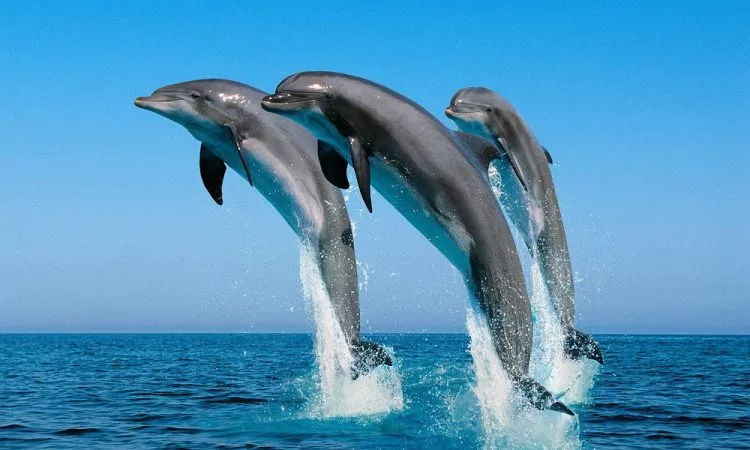
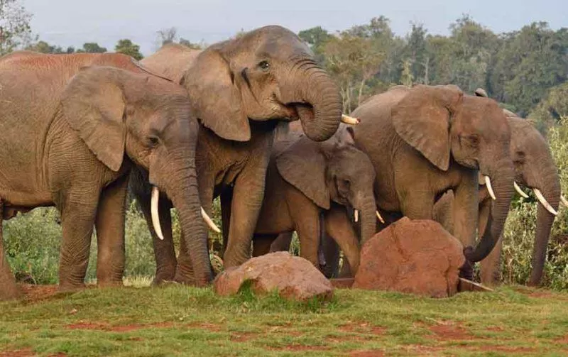
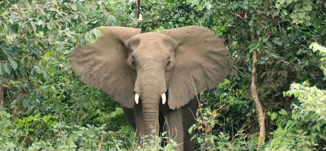
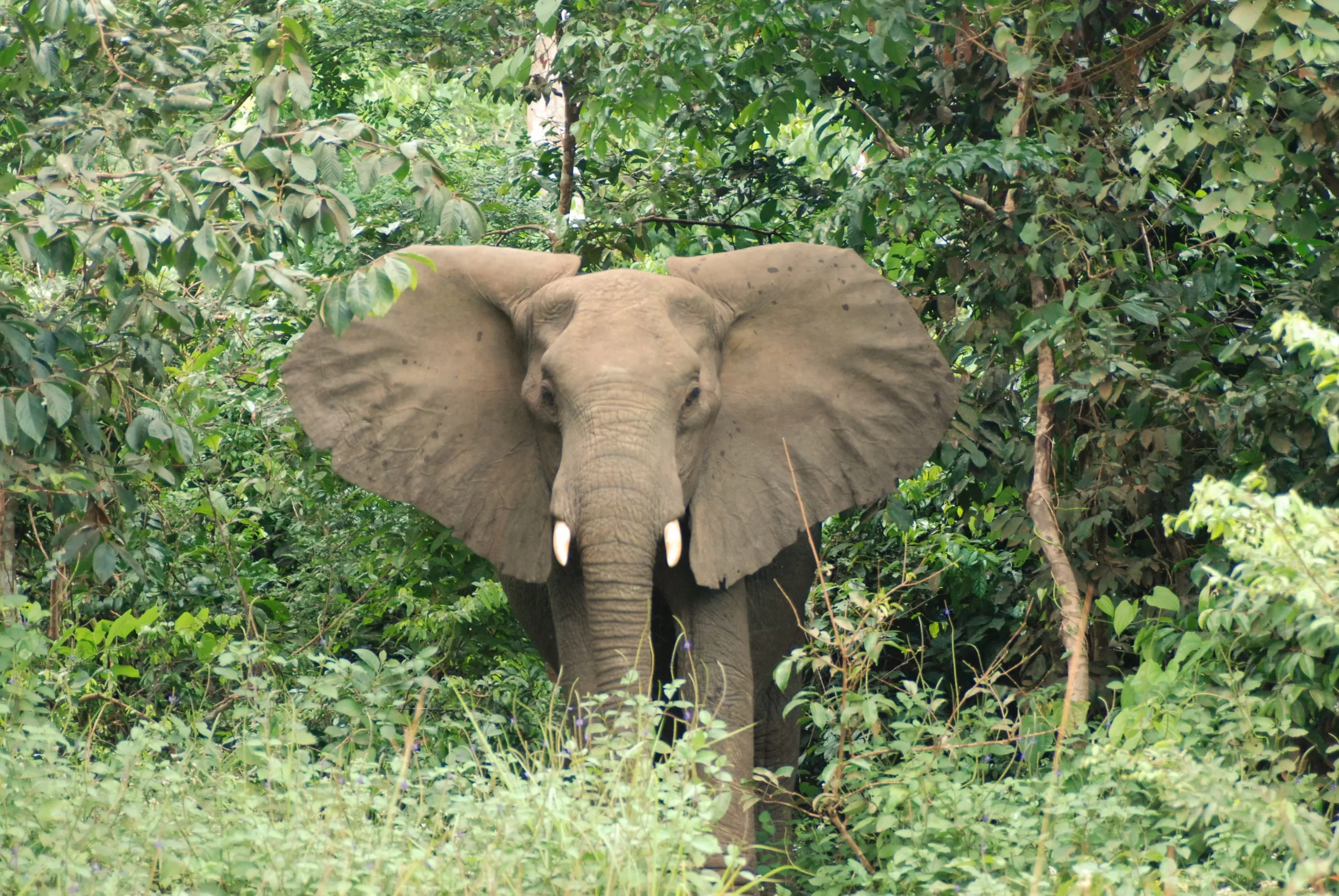
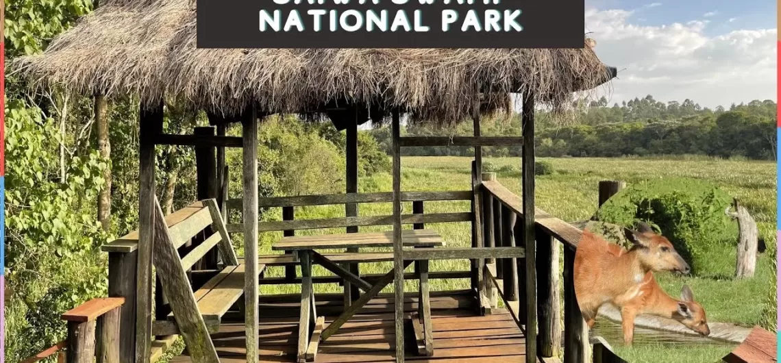
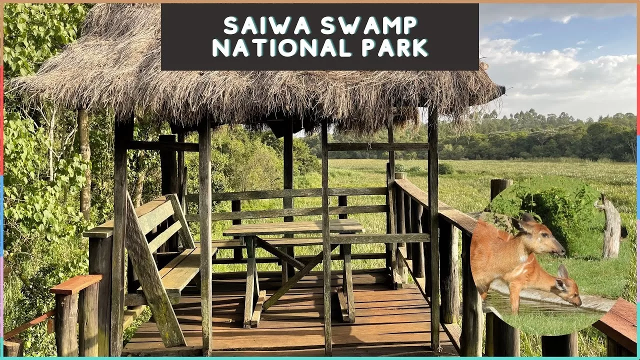
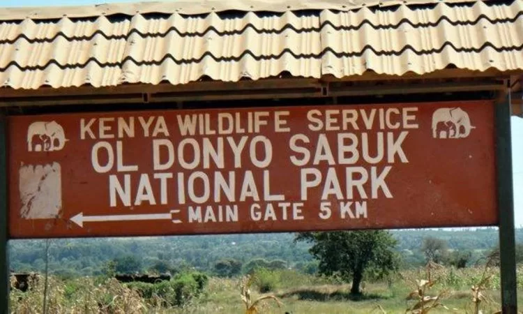
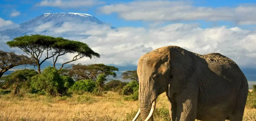


